Saint-Jean-Baptiste is a neighbourhood of Quebec City, which is the capital of the province of Quebec in Canada. Located immediately west of Old Quebec, it is known for its shopping and restaurants.
The Rue Saint Jean is the principal street in the district from (Avenue de Salaberry to Autoroute 175) with many independent cafes, bars and specialist grocery stores.
Along with Old Quebec, and Saint-Roch it forms the oldest part of the city. When the old city wall existed, the area was just west of the Port Saint Louis. Maps in 1776 have the area called Suburb or St John dotted with small hills and homes outside of the city walls.
On 28 June 1845 it was the site of the Second 1845 Quebec Fire (but not to be mistaken with the Great Fire of Quebec City) when the areas were called St. Jean.
Places of Interest
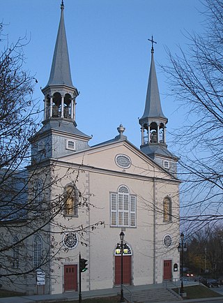
Cimetière Anglican Saint-Matthew and Parc Saint-Matthews
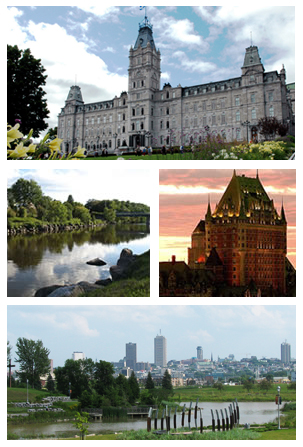
Quebec City, officially Québec, is the capital city of the Canadian province of Quebec. As of July 2021, the city had a population of 549,459, and the metropolitan area had a population of 839,311. It is the eleventh-largest city and the seventh-largest metropolitan area in Canada. It is also the second-largest city in the province, after Montreal. It has a humid continental climate with warm summers coupled with cold and snowy winters.
The Archdiocese of Québec is a Catholic archdiocese in Quebec, Canada. Being the first see in the New World north of Mexico, the Archdiocese of Québec is also the primatial see for Canada. The Archdiocese of Québec is also the ecclesiastical provincial for the dioceses of Chicoutimi, Sainte-Anne-de-la-Pocatière and Trois-Rivières. The archdiocese's cathedral is Notre-Dame de Québec in Quebec City.
Charlesbourg is a borough of Quebec City, in the northeastern part of the city, west of the borough of Beauport.
Lauzon is a former city in southern Quebec, Canada, located on the St. Lawrence River northeast of Lévis. Founded in 1867 as a village it became a town in 1910, Lauzon had a population of about 14,500 when it merged with Lévis in 1989. The then-amalgamated city had the name of Lévis-Lauzon for about one year in 1991, before merging again and changing its name for good to Lévis.
Ville-Marie is the name of a borough (arrondissement) in the centre of Montreal, Quebec. The borough is named after Fort Ville-Marie, the French settlement that would later become Montreal, which was located within the present-day borough. Old Montreal is a National Historic Site of Canada.
Villeray–Saint-Michel–Parc-Extension is a borough (arrondissement) in the city of Montreal, Quebec. It had a population of 143,853 according to the 2016 Census and a land area of 16.5 square kilometres (6.4 sq mi).
Villeray is a neighbourhood in Montreal, Quebec, Canada. It is part of the Villeray–Saint-Michel–Parc-Extension borough and is situated in the north-central part of the Island of Montreal.
Beauport is a borough of Quebec City, Quebec, Canada on the Saint Lawrence River.
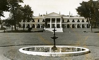
Quebec's Government House, known as Spencer Wood, was the viceregal residence of Quebec. It was built in 1854. Located at Bois-de-Coulonge Park in Sillery, it was purchased by the Quebec government in 1870, and served as the residence of Quebec lieutenant governors until 1966, when a major fire destroyed the main residence.
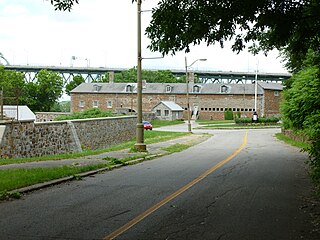
The Saint Helen Island Fort, a historic site on Saint Helen's Island in the city of Montreal, Quebec, was constructed in the early 1820s as an arsenal in the defensive chain of forts built to protect Canada from a threat of American invasion. Although not heavily fortified, it served an important purpose as the central artillery depot for all forts west, and in the Richelieu River Valley, known as the Valley of the Forts. These included Fort Henry and Fort Lennox. The red stone used to build the Fort is a breccia quarried on the island, which is situated in the St. Lawrence River between the island of Montreal and the south shore.
Park Extension is a neighbourhood in the city of Montréal, Québec. It is located in the borough of Villeray–Saint-Michel–Parc-Extension and has a population of 33,800 and an area of 1.6 km². The name derives from the fact that it is situated at the north end of Park Avenue and is literally an "extension" of the artery. The area is known by locals as "Park Ex."
Quebec County was a historic county in the province of Quebec, Canada. The county included the Quebec City metropolitan area and extended northwestward. The county seat was Loretteville.
La Cité-Limoilou is the central borough of Quebec City, the oldest, and the most populous, comprising 21.85% of the city's total population. As an administrative division, it is very new, having only been formed on November 1, 2009, from the former boroughs of La Cité and Limoilou.
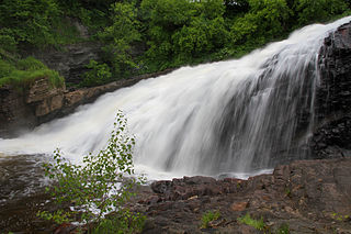
The Park of the Kabir Kouba Cliff and Waterfall is a public park in Quebec City, Quebec crossed by the Saint-Charles River. The rapids and falls of this section of the river are called Kabir Kouba the «river of a thousand bends» in the Montagnais language. An interpretive center and trails permit the observation of the Kabir Kouba waterfall that has a height of 28 metres. The trails also provide a view of the canyon which at its highest point measures 42 metres as well as a rich variety of flora, fauna and fossils dating over 455 million years old. The interpretive center also offers services such as Kabir Kouba by Lantern, A Day at Loretteville package as well as guided visits of the falls. A song by the singer Claire Pelletier, Kabir Kouba, evoques the many Huron legends that honour the river and the waterfall.
Duke of Kent House or Kent House is situated on the corner of Rue Saint-Louis and Haldimand, behind the Château Frontenac in Quebec City, named after its most famous resident Prince Edward, Duke of Kent and Strathearn. Though altered and transformed since its original construction, the most part of its foundations and of the first floor walls date back to about 1650, making it one of the oldest houses, if not the oldest house in Quebec City. In 1759, the Articles of Capitulation of Quebec were signed within the house. The present edifice has remained largely unchanged since 1819. It served as the French Consulate from 1980 to 2015.
Parliament Hill is located in Quebec City in the borough of La Cité-Limoilou, specifically in districts of Vieux-Québec—Cap-Blanc—colline Parlementaire and Saint-Jean-Baptiste. In addition to the Parliament Building of Quebec, the Hill has a few shopping streets and residential areas and public green spaces. The hill on which it is located is the promontory of Quebec.
Réserve faunique des Laurentides, also known by its former name of parc des Laurentides, is a wildlife reserve in Quebec, Canada, located between Quebec City and the Saguenay–Lac-Saint-Jean region. This reserve is part of the network of wildlife reserves of Quebec (Canada) managed by the Ministry of Energy and Natural Resources (Quebec) and the Société des établissements de plein air du Québec. It is located halfway between Saguenay and Quebec.
Aux Rochers River, is a river in Sept-Rivières Regional County Municipality, Côte-Nord, Quebec, Canada. It drains an area of 4,180 square kilometres (1,610 sq mi). It is a tributary of the Gulf of Saint Lawrence
Saint-Sauveur is one of the 35 neighborhoods of Quebec City, and one of the six that are situated within the borough of La Cité–Limoilou. It is one of the neighborhoods forming the Basse-Ville of Quebec City. The neighborhood is named after Jean Le Sueur.
This page is based on this Wikipedia article Text is available under the CC BY-SA 4.0 license; additional terms may apply. Images, videos and audio are available under their respective licenses.