Saint-Lambert, Abitibi-Témiscamingue

Last updated

Saint-Lambert
Pano Saint-Lambert.jpg
Saint-Lambert (Abitibi-Temiscamingue) Quebec location diagram.png
Location within Abitibi-Ouest RCM
Canada Western Quebec location map.png
Red pog.svg

St-Lambert
Location in western Quebec
Coordinates: 48°57′N79°28′W / 48.950°N 79.467°W / 48.950; -79.467 [1] [3]
CountryCanada
Province Quebec
Region Abitibi-Témiscamingue
RCM Abitibi-Ouest
Settled1922
ConstitutedMay 14, 1938
Government
[4]
  MayorDiane Provost
   Federal riding Abitibi—Témiscamingue
   Prov. riding Abitibi-Ouest
Area
  Total101.30 km2 (39.11 sq mi)
  Land99.81 km2 (38.54 sq mi)
Population
 (2021) [5]
  Total191
  Density1.9/km2 (5/sq mi)
  Pop (2016-21)
Decrease2.svg 1.5%
  Dwellings
95
Time zone UTC−05:00 (EST)
  Summer (DST) UTC−04:00 (EDT)
Postal code(s)
Area code 819
Website st-lambert.ao.ca OOjs UI icon edit-ltr-progressive.svg

Saint-Lambert is a parish municipality in northwestern Quebec, Canada, in the Abitibi-Ouest Regional County Municipality. It had a population of 191 in the 2021 Canadian census. The municipality was incorporated on May 14, 1938.

Contents

Demographics

In the 2021 Census of Population conducted by Statistics Canada, Saint-Lambert had a population of 191 living in 89 of its 95 total private dwellings, a change of -1.5% from its 2016 population of 194. With a land area of 99.81 km2 (38.54 sq mi), it had a population density of 1.9/km2 (5.0/sq mi) in 2021. [5]

Canada census – Saint-Lambert community profile
2021 2016 2011
Population191 (-1.5% from 2016)194 (-8.1% from 2011)211 (-5.0% from 2006)
Land area99.81 km2 (38.54 sq mi)100.23 km2 (38.70 sq mi)100.88 km2 (38.95 sq mi)
Population density1.9/km2 (4.9/sq mi)1.9/km2 (4.9/sq mi)2.1/km2 (5.4/sq mi)
Median age54.0 (M: 58.0, F: 50.4)51.0 (M: 52.0, F: 49.0)47.7 (M: 48.5, F: 46.0)
Private dwellings95 (total) 93 (total) 92 (total) 
Median household income$.N/A$52,096$.N/A
Notes: Income data for this area has been suppressed for data quality or confidentiality reasons.
References: 2021 [6] 2016 [7] 2011 [8] earlier [9] [10]
Historical census populations – Saint-Lambert, Abitibi-Témiscamingue
YearPop.±%
1941 384    
1951 665+73.2%
1956 770+15.8%
1961 705−8.4%
1966 673−4.5%
1971 628−6.7%
1976 471−25.0%
1981 381−19.1%
YearPop.±%
1986 296−22.3%
1991 305+3.0%
1996 268−12.1%
2001 251−6.3%
2006 222−11.6%
2011 211−5.0%
2016 194−8.1%
2021 191−1.5%
Source: Statistics Canada

Language

Canada Census Mother Tongue Language - Saint-Lambert, Abitibi-Témiscamingue, Quebec [11]
CensusTotal
French
English
French & English
Other
YearResponsesCountTrendPop %CountTrendPop %CountTrendPop %CountTrendPop %
2021
195
185Increase2.svg 2.8%94.9%5Steady2.svg 0.0%2.6%0Decrease2.svg 100.0%0.0%0Steady2.svg 0.0%0.0%
2016
195
180Decrease2.svg 14.3%92.3%5Increase2.svg n/a%2.6%5Increase2.svg n/a%2.6%0Steady2.svg 0.0%0.0%
2011
210
210Steady2.svg 0.0%100.0%0Steady2.svg 0.0%0.0%0Steady2.svg 0.0%0.0%0Steady2.svg 0.0%0.0%
2006
210
210Decrease2.svg 16.7%100.0%0Steady2.svg 0.0%0.0%0Decrease2.svg 100.0%0.0%0Steady2.svg 0.0%0.0%
2001
255
245Decrease2.svg 10.9%96.1%0Steady2.svg 0.0%0.0%10Steady2.svg 0.0%3.9%0Steady2.svg 0.0%0.0%
1996
285
275n/a96.5%0n/a0.0%10n/a3.5%0n/a0.0%

Government

Municipal council (as of 2023): [4]

List of former mayors:

See also

Related Research Articles

<span class="mw-page-title-main">Rouyn-Noranda</span> City in Quebec, Canada

Rouyn-Noranda is a city on Osisko Lake in the Abitibi-Témiscamingue region of Quebec, Canada.

<span class="mw-page-title-main">Abitibi Regional County Municipality</span> Regional county municipality in Quebec, Canada

Abitibi Regional County Municipality is a regional county municipality in the Abitibi-Témiscamingue region of Quebec. The seat is Amos.

<span class="mw-page-title-main">Témiscamingue Regional County Municipality</span> Regional county municipality in Quebec, Canada

Témiscamingue is a regional county municipality in the Abitibi-Témiscamingue region of western Quebec, Canada. The county seat is Ville-Marie.

<span class="mw-page-title-main">Abitibi-Témiscamingue</span> Administrative region in Quebec, Canada

ã

<span class="mw-page-title-main">Amos, Quebec</span> Town in Quebec, Canada

Amos is a town in northwestern Quebec, Canada, on the Harricana River. It is the seat of Abitibi Regional County Municipality.

<span class="mw-page-title-main">Ville-Marie, Quebec</span> City in Quebec, Canada

Ville-Marie is a town on Lake Temiscaming in western Quebec, Canada. It is the largest city and seat of the Témiscamingue Regional County Municipality. As one of the oldest towns in the Abitibi-Témiscamingue region, it is considered the cradle of north-western Quebec and nicknamed "Pearl of Témiscamingue".

<span class="mw-page-title-main">La Sarre</span> City in Quebec, Canada

La Sarre is a town in northwestern Quebec, Canada, and is the most populous town and seat of the Abitibi-Ouest Regional County Municipality. It is located at the intersection of Routes 111 and 393, on the La Sarre River, a tributary of Lake Abitibi.

<span class="mw-page-title-main">Senneterre</span> City in Quebec, Canada

Senneterre is a town in the Abitibi-Témiscamingue region of northwestern Quebec, Canada. It is in La Vallée-de-l'Or Regional County Municipality.

<span class="mw-page-title-main">Notre-Dame-du-Mont-Carmel, Quebec</span> Parish municipality in Quebec, Canada

Notre-Dame-du-Mont-Carmel in the Mauricie region of the province of Quebec in Canada.

<span class="mw-page-title-main">Launay, Quebec</span> Township municipality in Quebec, Canada

Launay is a township municipality in the Canadian province of Quebec, located in the Abitibi Regional County Municipality.

<span class="mw-page-title-main">Saint-Marc-de-Figuery</span> Parish municipality in Quebec, Canada

Saint-Marc-de-Figuery is a parish municipality in the Canadian province of Quebec, located in the Abitibi Regional County Municipality. It is part of the census agglomeration of Amos.

<span class="mw-page-title-main">Macamic</span> City in Quebec, Canada

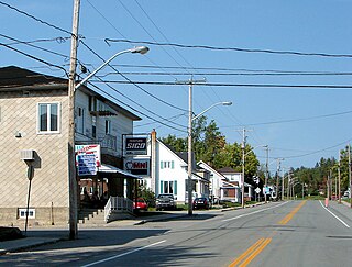
Macamic is a ville in northwestern Quebec, Canada, in the Abitibi-Ouest Regional County Municipality. It covers 202 km² and had a population of 2,744 in the 2021 Canadian census. It is located on the shores of the namesake Lake Macamic.

<span class="mw-page-title-main">Authier-Nord</span> Municipality in Quebec, Canada

Authier-Nord is a municipality in northwestern Quebec, Canada, in the Abitibi-Ouest Regional County Municipality. It covers 278.05 km2 (107.36 sq mi) and had a population of 288 as of the 2021 Canadian census.

<span class="mw-page-title-main">Chazel</span> Municipality in Quebec, Canada

Chazel is a municipality in northwestern Quebec, Canada, in the Abitibi-Ouest Regional County Municipality. It had a population of 254 in the 2021 Canadian census.

<span class="mw-page-title-main">Rapide-Danseur</span> Municipality in Quebec, Canada

Rapide-Danseur is a municipality in northwestern Quebec, Canada, in the Abitibi-Ouest Regional County Municipality. It covers 173.73 km2 and had a population of 380 as of the 2021 Canadian census.

<span class="mw-page-title-main">Clermont, Abitibi-Témiscamingue, Quebec</span> Township municipality in Quebec, Canada

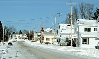
Clermont is a township municipality in northwestern Quebec, Canada, in Abitibi-Ouest Regional County Municipality. It had a population of 484 in the 2021 Canadian census. The population centre itself is sometimes referred to as Saint-Vital-de-Clermont.

<span class="mw-page-title-main">Nédélec</span> Township municipality in Quebec, Canada

Nédélec is a township municipality in western Quebec, Canada, in the Témiscamingue Regional County Municipality.

<span class="mw-page-title-main">Saint-Édouard-de-Fabre</span> Parish municipality in Quebec, Canada

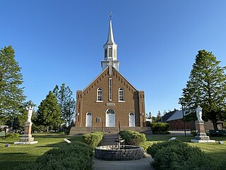
Saint-Édouard-de-Fabre is a parish municipality in western Quebec, Canada, in the Témiscamingue Regional County Municipality.

<span class="mw-page-title-main">Lac-Despinassy</span> Unorganized territory in Quebec, Canada

Lac-Despinassy is an unorganized territory in the Canadian province of Quebec, located within the Abitibi Regional County Municipality. The area is east of the municipality of Saint-Dominique-du-Rosaire, north of La Morandière-Rochebaucourt and the parish municipality of Senneterre, and west of the city of Senneterre.

<span class="mw-page-title-main">Rivière-Ojima</span> Unorganized territory in Quebec, Canada

Rivière-Ojima is an unorganized territory in the Abitibi-Témiscamingue region of Quebec, Canada. It consists of two non-contiguous areas in the Abitibi-Ouest Regional County Municipality, separated by the municipality of Authier-Nord. The hamlets of Languedoc and Saint-Eugène-de-Chazel are located within its boundaries.

References

  1. "Saint-Lambert,Abitibi-Témiscamingue". Geographical Names Data Base . Natural Resources Canada.
  2. "Saint-Lambert,Abitibi-Témiscamingue". Geographical Names Data Base . Natural Resources Canada.
  3. "Banque de noms de lieux du Québec: Reference number 57026". toponymie.gouv.qc.ca (in French). Commission de toponymie du Québec.
  4. 1 2 3 "Saint-Lambert". Répertoire des municipalités (in French). Ministère des Affaires municipales et de l'Habitation. Retrieved 2023-07-13.
  5. 1 2 3 "Saint-Lambert, Abitibi-Témiscamingue (Code 2487120) Census Profile". 2021 census . Government of Canada - Statistics Canada.
  6. "2021 Community Profiles". 2021 Canadian Census . Statistics Canada. February 4, 2022. Retrieved 2022-04-27.
  7. "2016 Community Profiles". 2016 Canadian Census . Statistics Canada. August 12, 2021. Retrieved 2023-07-13.
  8. "2011 Community Profiles". 2011 Canadian Census . Statistics Canada. March 21, 2019. Retrieved 2014-01-27.
  9. "2006 Community Profiles". 2006 Canadian Census . Statistics Canada. August 20, 2019.
  10. "2001 Community Profiles". 2001 Canadian Census . Statistics Canada. July 18, 2021.
  11. Statistics Canada: 1996, 2001, 2006, 2011, 2016 census