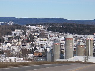
L'Anse-Saint-Jean, French for "The Cove of Saint John" is a municipality in the Saguenay–Lac-Saint-Jean region of Quebec, Canada. Its population was 1208 in the Canada 2011 Census.

Blainville is an off-island suburb of Montreal located in southwestern Quebec, Canada. Blainville forms part of the Thérèse-De Blainville Regional County Municipality within the Laurentides region of Quebec. The town sits at the foot of the Laurentian Mountains and is located 35 kilometres (22 mi) northwest of downtown Montreal.

Arthabaska Regional County Municipality is a regional county municipality located in the Centre-du-Québec region of Quebec. Its seat is Victoriaville.

Pierre-De Saurel is a regional county municipality in the Montérégie region in southwestern Quebec, Canada. Originally named Le Bas-Richelieu Regional County Municipality, the name change to Pierre-De Saurel took effect on January 1, 2009. Its seat is in Sorel-Tracy. It is located on the Richelieu River, downstream from La Vallée-du-Richelieu Regional County Municipality at the confluence of the Richelieu and Saint Lawrence River.

Minganie is a regional county municipality in the Côte-Nord region of Quebec, Canada. It includes Anticosti Island. Its seat is Havre-Saint-Pierre.

L'Assomption is an off-island suburb of Montreal, in southwestern Quebec, Canada on the L'Assomption River. It is the seat of the Regional County Municipality of L'Assomption. It is located on the outer fringes of the Montreal urban area.

Mont-Joli is a city in the La Mitis Regional County Municipality within the Bas-Saint-Laurent region of Quebec, Canada. It is the county seat. The city is located east of Rimouski near the south shore of the Saint Lawrence River.
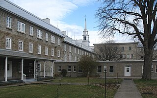
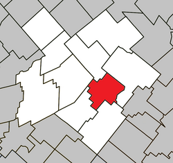
Notre-Dame-des-Anges is a parish municipality in Quebec, Canada, home of the General Hospital of Quebec.

Plessisville, Quebec is a county seat of L'Érable Regional County Municipality, Quebec, Canada. Routes 116 and 165 go through it. The city is 185 km from Montreal and 95 km from Quebec City. Plessisville's claim to fame is as the "World's Maple Capital"; the city has hosted an annual Maple festival since 1958, and the Institut québécois de l'érable is headquartered there. The production of maple syrup and maple products is a major industry in the entire area, even giving the regional county municipality its name.

Val-Brillant is a municipality in eastern Quebec, Canada, at the base of the Gaspé peninsula. On the southern shores of the Lake Matapedia, Val-Brillant is part of the Matapédia Valley.

Saint-Zotique is a municipality located within the Vaudreuil-Soulanges Regional County Municipality in the Montérégie region located about 45 minutes west of Montreal, Quebec, Canada. It is named for Saint Zoticus of Comana.
Très-Saint-Rédempteur is a municipality located in the Montérégie region of Quebec, Canada, along the border with Ontario. The population as of the Canada 2021 Census was 978. The municipality includes the town of Saint-Redempteur, and lies south of Rigaud along Route 325.

Saint-Pierre-de-Broughton is a municipality located in the Municipalité régionale de comté des Appalaches in Quebec, Canada. It is part of the Chaudière-Appalaches region and the population is 883 as of 2009.
Saint-Jean-Baptiste is a municipality in the Montérégie region of Quebec, a Canadian province. The population as of the Canada 2011 Census was 3,191. It is located within La Vallée-du-Richelieu Regional County Municipality in a valley between Mont Saint-Hilaire and Mont Rougemont.

Saint-Lambert-de-Lauzon is a municipality in La Nouvelle-Beauce Regional County Municipality in Quebec, Canada. It is part of the Chaudière-Appalaches region and the population is 6,177 as of the Canada 2011 Census. Prior to June 22, 2013 it was a parish municipality.

Saint-Sulpice is a municipality in the Lanaudière region of Quebec, Canada, part of the L'Assomption Regional County Municipality. It is located on the north shore of the Saint Lawrence River and includes most of Verchères Islands.

Saint-Pierre-de-l'Île-d'Orléans is a municipality in the Capitale-Nationale region of Quebec, Canada, part of the L'Île-d'Orléans Regional County Municipality. It is situated on the west side of Orléans Island, and accessible by Quebec Route 368 and the Île d'Orléans Bridge which connects Saint-Pierre with the Beauport borough of Quebec City. Until 1997, it was known simply as Saint-Pierre.

Saint-Jean-de-l'Île-d'Orléans is a municipality in the Capitale-Nationale region of Quebec, Canada. It is part of the L'Île-d'Orléans Regional County Municipality, on the southeastern side of Île d'Orléans.

Saint-Pierre-de-la-Rivière-du-Sud is a parish municipality in Quebec.
Saint-Tite-des-Caps is a municipality in La Côte-de-Beaupré Regional County Municipality in Quebec, Canada. Located on Route 138 to Baie-Saint-Paul, this road climbs up sharply to about 700 meters (2,300 ft) to reach the town nestled in a valley. The Sainte-Anne-du-Nord River forms the municipal western boundary.