Mesrop Mashtotslisten (help·info), also known as Mesrob the Vartabed, was an early medieval Armenian linguist, composer, theologian, statesman and hymnologist. He is best known for inventing the Armenian alphabet c. 405 AD, which was a fundamental step in strengthening Armenian national identity. He was also the creator of the Caucasian Albanian and Georgian alphabets, according to a number of scholars and contemporaneous Armenian sources.

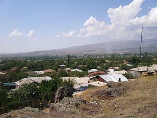
Ashtarak, is a town and urban municipal community in the Aragatsotn Province of Armenia, located on the left bank of Kasagh River along the gorge, northwest of the capital Yerevan. It is the administrative centre of the Aragatsotn province. Ashtarak is an important crossroad of routes for the Yerevan–Gyumri–Vanadzor rectangle.
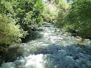
Kasagh is a river in the west-central region of modern Armenia which flows north to south. It originates near Mount Aragats in Aragatsotn province, flows south into Armavir province and into the Metsamor River, which itself is a tributary of the Aras River.
Mesrob or Mesrop is an Armenian given name.

Aparan, is a town and urban municipal community in Armenia, located in the Aragatsotn Province, about 50 kilometers northwest of the capital Yerevan. As of the 2011 census, the population of the town was 6,451. As per the 2016 official estimate, Aparan has a population of around 5,300.

The Caucasian Albanian alphabet was an alphabet used by the Caucasian Albanians, one of the ancient and indigenous Northeast Caucasian peoples whose territory comprised parts of present-day Azerbaijan and Daghestan. It was one of only two indigenous alphabets ever developed for speakers of indigenous Caucasian languages to represent any of their languages, the other being the Georgian alphabet. The Armenian language, the third language of Caucasus with its own alphabet, is an independent branch of the Indo-European language family.
Voskevaz is a village in the Aragatsotn province of Armenia. Not far from the center of the village is the church of Surp Hovhannes, built between the 7th and 12th centuries. The village is home to the Hayasy brewery.

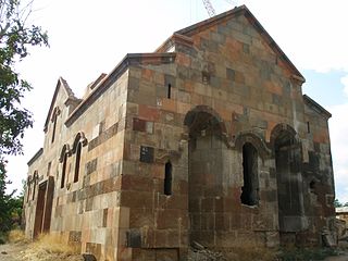
Aghdzk is a village on the slopes of Mount Aragats in the Aragatsotn Province of Armenia. It is home to the Arshakid Mausoleum, a large grave monument complex and basilica of the 4th to 5th centuries. King Shapur II of Persia exhumed the bones of the Armenian kings and took them to Persia symbolically taking Armenia's power. When Sparapet Vassak Mamikonian defeated the Persians and reclaimed the bones of the Arshakuni monarchs, he buried them at Aghdzk. Remains of the monuments and the basilica may still to be seen.
Dzoraglukh is a town in the Aragatsotn Province of Armenia. The town's church, dedicated to Saint Hovhannes, dates from the 10th to the 12th century.

Mughni is a village in the Aragatsotn Province of Armenia. It is located just to the north of Ashtarak town and belongs to its municipality. Until the Russian conquest, it was the southernmost town in the district of Aparan. Mughni is home to the 14th-century Saint Gevork Monastery, which was formerly a popular pilgrimage site and the seat of an archbishop. The dome of the church was rebuilt in the 1660s.
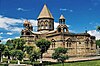
Saghmosavan is a town in the Aragatsotn Province of Armenia. The town is the site of the Saghmosavank Monastery with Saint Sion church, built in 1215.
Ttujur is a village in the Aragatsotn Province of Armenia. The village 's church is dedicated to Saint Harutyun. The village also contains a 17th-century shrine called "Karmir Vank".
Avan is a village in the Aragatsotn Province of Armenia. The population of the village is mainly Armenian. It is home to the basilica-style church of Surb Astvatsatsin that sits along a street just off the main road beside the main cemetery. The large cemetery contains many khachkars from the 13th to 18th centuries. Adjacent to it across the street is a stepped plinth and broken funerary pillar monument of the 5th to 6th centuries. A worn inscription may be found along the landings of the second and third steps. There is a newly built church also by the name of Surb Astvatsatsin that sits near the main highway closer to the centre of the village, and is said to have been constructed upon old foundations. Some confusion may arise since two churches in the village are referred to as S. Astvatsatsin, but one of them may be the church of S. Hovhannes. They are said to have been first built in the 5th to 6th centuries, were reconstructed in the 13th century, and have sat in ruins until recently since the earthquake of 1679.

Nəsirvaz formerly Mesropavan is a village in the Ordubad Rayon of Nakhchivan, Azerbaijan. In the municipality of Bist village, it is located near the Ordubad-Nurgut highway, to the north-west of the district center, on the foothill. It has a population of 157.
Mesropavan is a historical village in Goghtn Region of Armenia, currently included into Ordubad region of Nakhichevan autonomy of Azerbaijan.
The Monastery of Saint Translators is an Armenian monastery, founded in the 4th century. It is located north of Daşkəsən, in Azerbaijan.

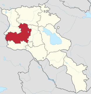
Diocese of Aragatsotn, is a diocese of the Armenian Apostolic Church covering the Aragatsotn Province of Armenia. The name is derived from the historic Aragatsotn canton of Ayrarat province of Kingdom of Armenia.