
Saint-Jean-sur-Richelieu is a city in eastern Montérégie in the Canadian province of Quebec, about 40 kilometres (25 mi) southeast of Montreal, located roughly halfway between Montreal and the Canada–United States border with the state of Vermont. It is situated on both the west and east banks of the Richelieu River at the northernmost navigable point of Lake Champlain. As of December 2019, the population of Saint-Jean-sur-Richelieu was 98,036.

La Vallée-du-Richelieu is a regional county municipality in the Montérégie region in southwestern Quebec, Canada. Its seat is McMasterville.

Sainte-Julie, is an off-island suburb of Montreal, in southwestern Quebec, Canada, east of Montreal in Marguerite-D'Youville Regional County Municipality. The population as of the Canada 2021 Census was 30,045. In 2009 Sainte-Julie was called one of the best towns in which to live in Quebec, and the city is often known as "The Happiest City in Quebec".

Chambly is an off-island suburb of Montreal in southwestern Quebec, Canada. It is located in the Montérégie region, inland from the South Shore of the Saint Lawrence River.

Mont-Saint-Hilaire is a suburb of Montreal on the South Shore of southeastern Quebec, Canada, on the Richelieu River in the Regional County Municipality of La Vallée-du-Richelieu. The population as of the Canada 2021 Census was 18,859. The city is named after the Mont Saint-Hilaire.

Saint-Mathieu-de-Beloeil is a municipality in southwestern Quebec, Canada, east of Montreal in the Regional County Municipality of La Vallée-du-Richelieu. The population as of the 2021 Canadian Census was 2,952.

Otterburn Park is a small town located 40 kilometres (25 mi) east of Montreal, Quebec, Canada. The population as of the Canada 2021 Census was 8,479. The town lies south of Mont-Saint-Hilaire on the Richelieu River and is one of the few officially bilingual towns in Quebec.

Saint-Bernard-de-Lacolle is a municipality in Les Jardins-de-Napierville Regional County Municipality, Quebec, Canada, located in the administrative area of Montérégie. Saint-Bernard-de-Lacolle was established as a municipality officially in 1855, and its population as of the 2021 Canadian census was 1,542.
Richelieu is a city in Rouville Regional County Municipality, in the province of Quebec, Canada. The population as of the Canada 2021 Census was 5,742. Its name comes from the fact that it lies along the Richelieu River.
Saint-Patrice-de-Sherrington is a municipality in Les Jardins-de-Napierville Regional County Municipality in Quebec, Canada, situated in the Montérégie administrative region. The population as of the 2021 Canadian census was 1,963.

Saint-Basile-le-Grand is a city located in La Vallée-du-Richelieu Regional County Municipality in southwestern Quebec, Canada. The population as of the 2021 Canadian Census was 17,053.

McMasterville is a city in southwestern Quebec, Canada on the Richelieu River in La Vallée-du-Richelieu Regional County Municipality. The population as of the 2021 Canadian Census was 5,936. It is within the Administrative Region of Montérégie.

Saint-Blaise-sur-Richelieu is a municipality in the Canadian province of Quebec. The population as of the Canada 2016 Census was 2,066. The town was founded in 1892.

Marieville is a city in the Canadian province of Quebec. It is located within the Rouville Regional County Municipality in the Montérégie region about 30 km (19 mi) east of Montreal. The population as of the Canada 2021 Census was 11,332.
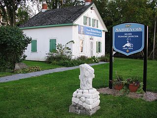
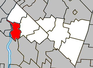
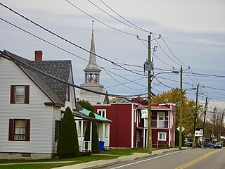
Sainte-Anne-de-Sabrevois is a parish municipality in the province of Quebec, Canada, located in the Regional County Municipality of Le Haut-Richelieu. The population as of the Canada 2011 Census was 2,074.

Saint-Paul-de-l'Île-aux-Noix is a municipality in southern Quebec, Canada located in the administrative area of the Montérégie. The population as of the Canada 2021 Census was 2,141.

Rougemont is a municipality in the Canadian province of Quebec, located within the Rouville Regional County Municipality in the Montérégie region about 18 kilometers southwest of Saint-Hyacinthe. The population as of the Canada 2021 Census was 2,696.
Saint-Jean-Baptiste is a municipality in the Montérégie region of Quebec, a Canadian province. The population as of the Canada 2021 Census was 3,179. It is located within La Vallée-du-Richelieu Regional County Municipality in a valley between Mont Saint-Hilaire and Mont Rougemont.

Saint-Cyprien is a parish in the Les Etchemins Regional County Municipality in Quebec, Canada. It is part of the Chaudière-Appalaches region and the population is 490 as of 2016. It is named after Christian martyr Cyprian.
The South Shore Protestant Regional School Board (SSPRSB) was a Protestant Christian school district in Greater Montreal, Quebec, Canada. It served the South Shore region and it was headquartered in St. Lambert.


