Sainte-Marie-Madeleine, Quebec

Last updated

Sainte-Marie-Madeleine
Rest stop Halte des Hurons.jpg
Sainte-Marie-Madeleine Quebec location diagram.PNG
Location within Les Maskoutains RCM.
Canada Southern Quebec location map.png
Red pog.svg
Sainte-Marie-Madeleine
Location in southern Quebec.
Coordinates: 45°36′N73°06′W / 45.600°N 73.100°W / 45.600; -73.100 [1]
CountryFlag of Canada (Pantone).svg  Canada
Province Flag of Quebec.svg  Quebec
Region Montérégie
RCM Les Maskoutains
ConstitutedAugust 13, 1879
Government
  MayorGinette Gauvin
   Federal riding Saint-Hyacinthe—Bagot
   Prov. riding Borduas
Area
  Total49.80 km2 (19.23 sq mi)
  Land50.04 km2 (19.32 sq mi)
 There is an apparent
contradiction between two
authoritative sources
Population
 (2021) [4]
  Total2,876
  Density57.5/km2 (149/sq mi)
  Pop 2016-2021
Decrease2.svg 0.6%
  Dwellings
1,190
Time zone UTC−5 (EST)
  Summer (DST) UTC−4 (EDT)
Postal code(s)
Area code(s) 450 and 579
Highways
Quebec Autoroute 20.svgTrans-Canada Highway shield.svg A-20 (TCH)

Qc116.svg R-116
Qc227.svg R-227
Qc229.svg R-229
Website www.sainte-marie
-madeleine.ca

Sainte-Marie-Madeleine is a parish municipality in southwestern Quebec, Canada, in Les Maskoutains Regional County Municipality. The population as of the Canada 2021 Census was 2,876.

Contents

Demographics

Historical Census Data - Sainte-Marie-Madeleine, Quebec [5]
YearPop.±%
1881 995    
1891 936−5.9%
1901 1,037+10.8%
1911 1,039+0.2%
1921 611−41.2%
1931 579−5.2%
1941 588+1.6%
1951 570−3.1%
1956 631+10.7%
1961 642+1.7%
1966 643+0.2%
1971 697+8.4%
1976 963+38.2%
1981 1,516+57.4%
1986 1,678+10.7%
1991 2,113+25.9%
1996 2,262+7.1%
2001 2,466+9.0%
2006 2,678+8.6%
2011 2,935+9.6%
2016 2,892−1.5%
2021 2,876−0.6%

In the 2021 Census of Population conducted by Statistics Canada, Sainte-Marie-Madeleine had a population of 2,876 living in 1,169 of its 1,190 total private dwellings, a change of -0.6% from its 2016 population of 2,892. With a land area of 50.04 km2 (19.32 sq mi), it had a population density of 57.5/km2 (148.9/sq mi) in 2021. [6]

Canada census – Sainte-Marie-Madeleine community profile
2021 2016 2011
Population2,876 (-0.6% from 2016)2,892 (-1.5% from 2011)2,935 (+9.6% from 2006)
Land area50.04 km2 (19.32 sq mi)50.13 km2 (19.36 sq mi)50.87 km2 (19.64 sq mi)
Population density57.5/km2 (149/sq mi)57.7/km2 (149/sq mi)57.7/km2 (149/sq mi)
Median age42.4 (M: 42, F: 42.4)41.2 (M: 41.0, F: 41.4)38.3 (M: 38.1, F: 39.0)
Private dwellings1,170 (total) 1,167 (total) 1,141 (total) 
Median household income$86,000$73,574$62,152
References: 2021 [4] 2016 [7] 2011 [8] earlier [9] [10]
Canada Census Mother Tongue - Sainte-Marie-Madeleine, Quebec [5]
CensusTotal
French
English
French & English
Other
YearResponsesCountTrendPop %CountTrendPop %CountTrendPop %CountTrendPop %
2021
2,875
2,785Decrease2.svg 0.5%96.9%30Steady2.svg 0.0%1.0%15Increase2.svg 200.0%0.5%40Decrease2.svg 11.1%1.4%
2016
2,890
2,800Decrease2.svg 1.9%96.9%30Decrease2.svg 14.3%1.0%5Decrease2.svg 75.0%0.2%45Increase2.svg 80.0%1.6%
2011
2,935
2,855Increase2.svg 14.7%97.3%35Decrease2.svg 30.0%1.2%20Increase2.svg 100.0%0.7%25Decrease2.svg 75.0%0.9%
2006
2,650
2,490Increase2.svg 3.3%94.0%50Increase2.svg 233.3%1.9%10Decrease2.svg 33.3%0.4%100Increase2.svg 400.0%3.8%
2001
2,460
2,410Increase2.svg 10.6%98.0%15Decrease2.svg 72.7%0.6%15Increase2.svg 50.0%0.6%20Steady2.svg 0.0%0.8%
1996
2,265
2,180n/a96.3%55n/a2.4%10n/a0.4%20n/a0.9%

See also

Related Research Articles

<span class="mw-page-title-main">Berthierville</span> City in Quebec, Canada

Berthierville (also called Berthier-en-haut, and legally called Berthier before 1942) is a town located between Montreal and Trois-Rivières on the north shore of the Saint Lawrence River in Quebec, Canada. Berthierville is the seat of D'Autray Regional County Municipality, and is served by Autoroute 40, and is the junction of Routes 138 and 158. It is surrounded by the parish municipality of Sainte-Geneviève-de-Berthier.

<span class="mw-page-title-main">Sainte-Catherine, Quebec</span> City in Quebec, Canada

Sainte-Catherine is an off-island suburb of Montreal, in southwestern Quebec, Canada, on the St. Lawrence River in the Regional County Municipality of Roussillon. The population as of the Canada 2011 Census was 16,762.

<span class="mw-page-title-main">Chandler, Quebec</span> City in Quebec, Canada

Chandler is a town in the Gaspésie–Îles-de-la-Madeleine region of Quebec, Canada. It is the second-most populous town on the Gaspé Peninsula after the Town of Gaspé. It was known as Pabos between June 27, 2001 and May 4, 2002.

<span class="mw-page-title-main">Sainte-Madeleine, Quebec</span> Village municipality in Quebec, Canada

Sainte-Madeleine is a village municipality in southwestern Quebec, Canada in Les Maskoutains Regional County Municipality. The population as of the Canada 2011 Census was 2,356.

<span class="mw-page-title-main">L'Île-Perrot</span> City in Quebec, Canada

The Town of Île-Perrot is a town and municipality on Île Perrot in southwestern Quebec, Canada. The population as of the Canada 2016 Census was 10,756. The town is at the western end of Lake Saint-Louis, and borders the local island communities of Terrasse-Vaudreuil, Pincourt and Notre-Dame-de-l'Île-Perrot. It also includes Dowker Island and the small Claude and Bellevue Islands.

<span class="mw-page-title-main">Sainte-Christine, Quebec</span> Parish municipality in Quebec, Canada

Sainte-Christine is a parish municipality in Acton Regional County Municipality, in the province of Quebec, Canada. The population as of the Canada 2016 Census was 730.

<span class="mw-page-title-main">Sainte-Jeanne-d'Arc, Bas-Saint-Laurent, Quebec</span> Parish municipality in Quebec, Canada

Sainte-Jeanne-d'Arc is a parish municipality in La Mitis Regional County Municipality in the Bas-Saint-Laurent region of Quebec, Canada. Its population in the Canada 2021 Census was 217.

<span class="mw-page-title-main">Sainte-Perpétue, Centre-du-Québec</span> Parish municipality in Quebec, Canada

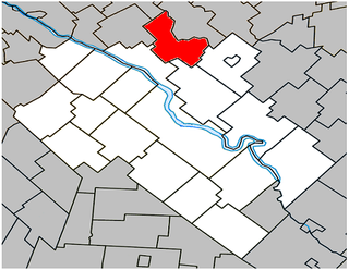
Sainte-Perpétue is a parish municipality in the Centre-du-Québec region of Quebec, Canada, situated along Route 259. The population as of the Canada 2021 Census was 916.

<span class="mw-page-title-main">Saint-Philippe, Quebec</span> City in Quebec, Canada

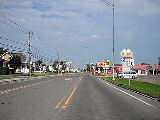
Saint-Philippe is a city located in Roussillon Regional County Municipality in the Montérégie region of Quebec, Canada. It was established on July 1, 1855. The population as of the Canada 2021 Census was 7,597.

<span class="mw-page-title-main">Notre-Dame-de-l'Île-Perrot</span> City in Quebec, Canada

Notre-Dame-de-l'Île-Perrot is the largest of four municipalities located on Île Perrot, west of the island of Montreal, Quebec. The population as of the Canada 2016 Census was 10,654. It hosts the island's first church built in 1740 originally situated at Pointe-du-Moulin which was reconstituted as the Chapelle du Souvenir in 1953 beside the church of Sainte-Jeanne-de-Chantal across from the town hall.

<span class="mw-page-title-main">Marieville</span> City in Quebec, Canada

Marieville is a city in the Canadian province of Quebec. It is located within the Rouville Regional County Municipality in the Montérégie region about 30 km (19 mi) east of Montreal. The population as of the Canada 2021 Census was 11,332.

<span class="mw-page-title-main">Saint-Damien, Quebec</span> Parish municipality in Quebec, Canada

Saint-Damien is a parish municipality of 2,393 inhabitants in Quebec, Canada. It is located in Matawinie Regional County Municipality in the Lanaudière region.

<span class="mw-page-title-main">Pont-Rouge</span> City in Quebec, Canada

Pont-Rouge is a city along the Jacques-Cartier River in southern Quebec, Canada. In the Canada 2021 Census the population was 10,121 inhabitants.

<span class="mw-page-title-main">L'Île-Cadieux</span> City in Quebec, Canada

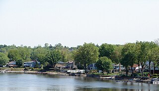
L'Île-Cadieux is a village and municipality in the Montérégie region of Quebec, Canada, part of the Vaudreuil-Soulanges Regional County Municipality. It is located on and contiguous with Cadieux Island, which projects into Lake of Two Mountains just north off Vaudreuil-sur-le-Lac. The population as of the Canada 2011 Census was 105.

<span class="mw-page-title-main">Sainte-Anne-de-Sabrevois</span> Parish municipality in Quebec, Canada

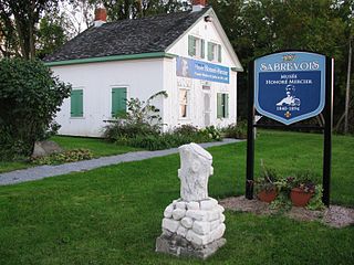
Sainte-Anne-de-Sabrevois is a parish municipality in the province of Quebec, Canada, located in the Regional County Municipality of Le Haut-Richelieu. The population as of the Canada 2011 Census was 2,074.

<span class="mw-page-title-main">Sainte-Marie, Quebec</span> City in Quebec, Canada

Sainte-Marie is a city in the province of Quebec, Canada. It is the seat of the Municipalité régionale de la Nouvelle-Beauce, in Chaudière-Appalaches, Quebec, Canada. The population was 13,134 as of the Canada 2021 Census, and was 95.7% French-speaking as of 2021. It is located 59 kilometres (37 mi) south-east of Quebec City, on the Chaudière River.

<span class="mw-page-title-main">Sainte-Brigitte-des-Saults, Quebec</span> Parish municipality in Quebec, Canada

Sainte-Brigitte-des-Saults is a parish municipality in the Centre-du-Québec region of southwestern Quebec. The population as of the Canada 2011 Census was 737.

<span class="mw-page-title-main">Fossambault-sur-le-Lac</span> City in Quebec, Canada

Fossambault-sur-le-Lac is a city in the south part of Quebec, Canada, in La Jacques-Cartier Regional County Municipality, just north of Quebec City. It had a population of 2,327 as of the Canada 2021 Census. It is located near Saint-Joseph Lake.

<span class="mw-page-title-main">Sainte-Irène</span> Parish municipality in Quebec, Canada

Sainte-Irène is a parish municipality in Quebec, Canada.

<span class="mw-page-title-main">Sainte-Françoise, Bas-Saint-Laurent, Quebec</span> Parish municipality in Quebec, Canada

Sainte-Françoise is a parish municipality in the Bas-Saint-Laurent region of Quebec, Canada.

References

  1. "Banque de noms de lieux du Québec: Reference number 56329". toponymie.gouv.qc.ca (in French). Commission de toponymie du Québec.
  2. 1 2 Ministère des Affaires municipales, des Régions et de l'Occupation du territoire: Sainte-Marie-Madeleine
  3. Parliament of Canada Federal Riding History: SAINT-HYACINTHE--BAGOT (Quebec)
  4. 1 2 3 "2021 Community Profiles". 2021 Canadian Census . Statistics Canada. February 4, 2022. Retrieved 2022-04-27.
  5. 1 2 Statistics Canada: 1996, 2001, 2006, 2011, 2016, 2021 census
  6. "Population and dwelling counts: Canada, provinces and territories, and census subdivisions (municipalities), Quebec". Statistics Canada. February 9, 2022. Retrieved August 29, 2022.
  7. "2016 Community Profiles". 2016 Canadian Census . Statistics Canada. August 12, 2021. Retrieved 2024-06-17.
  8. "2011 Community Profiles". 2011 Canadian Census . Statistics Canada. March 21, 2019. Retrieved 2014-03-25.
  9. "2006 Community Profiles". 2006 Canadian Census . Statistics Canada. August 20, 2019.
  10. "2001 Community Profiles". 2001 Canadian Census . Statistics Canada. July 18, 2021.