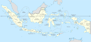
Provinces are the first-level administrative divisions of Indonesia. It is formerly called the first-level provincial region before the Reform era. Provinces have a local government, consisting of a governor and a regional legislative body. The governor and members of local representative bodies are elected by popular vote for five-year terms, but governors can only serve for two terms. Provincial governments have the authority to regulate and manage their own government affairs, subject to the limits of the central government. The average land area of all 38 provinces in Indonesia is about 49,800 km2 (19,200 sq mi), and they had an average population in mid 2023 of 7,334,111 people.

West Kalimantan is a province of Indonesia. It is one of five Indonesian provinces comprising Kalimantan, the Indonesian part of the island of Borneo. Its capital and largest city is Pontianak. It is bordered by East Kalimantan and Central Kalimantan to the east, the Malaysian state of Sarawak to the north, and the Bangka Belitung Islands to the west and the Java Sea to the south. The province has an area of 147,037 km2, and had a population of 4,395,983 at the 2010 Census and 5,414,390 at the 2020 Census; the official estimate as at mid 2023 was 5,623,328, and was projected to rise to 5,695,500 at mid 2024. Ethnic groups include the Dayak, Malay, Chinese, Javanese, Bugis, and Madurese. The borders of West Kalimantan roughly trace the mountain ranges surrounding the vast watershed of the Kapuas River, which drains most of the province. The province shares land borders with Central Kalimantan to the southeast, East Kalimantan to the east, and the Malaysian territory of Sarawak to the north.

South Kalimantan is a province of Indonesia. It is the smallest province in Kalimantan, the Indonesian territory of the island of Borneo. The provincial capital was Banjarmasin until 15 February 2022 when it was legally moved 35 kms southeast to Banjarbaru. The population of South Kalimantan was recorded at just over 3.625 million people at the 2010 Census, and at 4.07 million at the 2020 Census. The official estimate as at mid 2023 was 4,221,929. One of the five Indonesian provinces in Kalimantan, it is bordered by the Makassar Strait in the east, Central Kalimantan in the west and north, the Java Sea in the south, and East Kalimantan in the northeast. The province also includes the island of Pulau Laut, located off the eastern coast of Kalimantan, as well as other smaller offshore islands. The province is divided into 11 regencies and 2 cities. South Kalimantan is the traditional homeland of the Banjar people, although some parts of East Kalimantan and Central Kalimantan are also included in this criterion. Nevertheless, South Kalimantan, especially the former capital city Banjarmasin has always been the cultural capital of Banjarese culture. Many Banjarese have migrated to other parts of Indonesia, as well as neighbouring countries such as Singapore and Malaysia. In addition, other ethnic groups also inhabit the province, such as several groups of the Dayaks, who mostly live in the interior part of the province, as well as the Javanese, who mostly migrated from Java due to the Transmigration program which dated from the Dutch colonial era. It is one of the provinces in Indonesia that has a larger population than Mongolia.

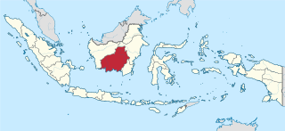
Central Kalimantan is a province of Indonesia. It is one of five provinces in Kalimantan, the Indonesian part of Borneo. It is bordered by West Kalimantan to the west, South Kalimantan and East Kalimantan to the east, Java Sea to the south and is separated narrowly from North Kalimantan and Malaysia by East Kalimantan's Mahakam Ulu Regency. Its provincial capital is Palangka Raya and in 2010 its population was over 2.2 million, while the 2020 Census showed a total of almost 2.67 million; the official estimate as at mid 2023 was 2,774,747, and was projected to rise to 2,809,700 at mid 2024.

East Kalimantan is a province of Indonesia. Its territory comprises the eastern portion of Borneo. It had a population of about 3.03 million at the 2010 census, 3.42 million at the 2015 census, and 3.766 million at the 2020 census; the official estimate as at mid 2023 was 4,030,488. Its capital is the city of Samarinda.

Lampung, officially the Province of Lampung, is a province of Indonesia. It is located on the southern tip of the island of Sumatra. It has a short border with the province of Bengkulu to the northwest, and a longer border with the province of South Sumatra to the north, as well a maritime border with the province of Banten and Jakarta to the east. It is the original home of the Lampung people, who speak their own language, and possess their own written script. Its capital is Bandar Lampung.

West Nusa Tenggara is a province of Indonesia. It comprises the western portion of the Lesser Sunda Islands, with the exception of Bali which is its own province. The province's land area is 19,675.89 km2. The two largest islands by far in the province are the smaller but much more populated Lombok in the west and the much larger in area but much less densely populated Sumbawa island in the east. Mataram, on Lombok, is the capital and largest city of the province. It shares maritime borders with Bali to the west and East Nusa Tenggara to the east.

Bengkayang Regency is a regency ("kabupaten") in West Kalimantan Province of Indonesia,. The area was originally a part of Sambas Regency, but following the expansion of the population in that area, Sambas Regency was divided into a smaller Sambas Regency and a new Bengkayang Regency on 20 April 1999, and then Singkawang City was subsequently cut out of Bengkayang Regency on 21 June 2001. The regency now covers an area of 5,382.74 km2, and had a population of 215,277 at the 2010 Census and 286,366 at the 2020 Census; the official estimate as at mid 2023 was 298,979. The administrative centre is in the town of Bengkayang.

Kapuas Hulu Regency is a regency in West Kalimantan province of Indonesia. Located around the upper drainage area of the Kapuas River, it has a total land area of 31,318.25 square kilometres or around 21.3% of West Kalimantan province's area. The regency seat is located in town of Putussibau, where most of its economic and government activities take place. Kapuas Hulu Regency is one of the few Indonesian regencies having a land border with another country. It is also the largest regency in the province by land area. Due to its relatively large area, it is sparsely populated compared to neighbouring regencies around it. The regency had a population of 222,160 at the 2010 Census and 252,609 according to the 2020 Census; the official estimate as at mid 2023 was 262,404.
In Indonesia, village or subdistrict is the fourth-level subdivision and the smallest administrative division of Indonesia below a district, regency/city, and province. Similar administrative divisions outside of Indonesia include barangays in the Philippines, Muban in Thailand, civil townships and incorporated municipalities in the United States and Canada, communes in France and Vietnam, dehestan in Iran, hromada in Ukraine, Gemeinden in Germany, comuni in Italy, or municipios in Spain. The UK equivalent are civil parishes in England and communities in Wales. There are a number of names and types for villages in Indonesia, with desa being the most frequently used for regencies, and kelurahan for cities or for those communities within regencies which have town characteristics. According to the 2019 report by the Ministry of Home Affairs, there are 8,488 urban villages and 74,953 rural villages in Indonesia. North Aceh Regency contained the highest number of rural villages (852) amongst all of the regencies of Indonesia, followed by Pidie Regency with 730 rural villages and Bireuen Regency with 609 rural villages. Prabumulih, with only 12 rural villages, contained the fewest. Counted together, the sixteen regencies of Indonesia containing the most rural villages—namely, North Aceh (852), Pidie (730), Bireuen (609), Aceh Besar (604), Tolikara (541), East Aceh (513), Yahukimo (510), Purworejo (469), Lamongan (462), South Nias (459), Kebumen (449), Garut (421), Bojonegoro (419), Bogor (416), Cirebon (412), and Pati (401)—contain one-third of all the rural villages in Indonesia. Five of these are located in Aceh, two in Highland Papua, three in Central Java, two in East Java, three in West Java, and one in North Sumatra. An average number of rural villages in the regencies and 15 cities of Indonesia is 172 villages. A village is the lowest administrative division in Indonesia, and it is the lowest of the four levels. The average land area of villages in Indonesia is about 25.41 km2 (9.81 sq mi), while its average population is about 3,723 people.

Pidie Regency is a regency of Aceh Special region, in Indonesia. It is located in the north of the island of Sumatra, in Western Indonesia, bordered by the Malacca Strait and Pidie Jaya Regency in the north, Aceh Besar Regency in the west, Bireuen Regency in the northeast, and Aceh Jaya Regency in the south. The regency covers an area of 3,184.46 square kilometres and had a population of 379,108 people at the 2010 Census and 435,275 at the 2020 Census; the official estimate as at mid 2023 was 448,085 - comprising 223,208 males and 224,877 females. Pidie was the largest rice-producing area of Aceh province, producing some 20% of its total output.

Kotabaru Regency is one of the eleven regencies in the Indonesian province of South Kalimantan. It consists of two parts; the smaller but more populated insular part comprises Laut Island, the largest island off the coast of Kalimantan, together with the smaller Sebuku Island off Laut Island's east coast and other even smaller islands nearby; the larger but less populated part consists of the 12 districts on the mainland of Kalimantan. The regency as a whole has an area of 9,480.17 km2, and had a population of 290,142 at the 2010 Census and 325,622 at the 2020 Census. The official estimate as at mid 2023 was 329,641, of whom 177,148 were in the insular part and 152,493 in the mainland part of the regency. The regency seat is located at the large town of Kotabaru at the northern tip of Laut Island.
Selakoa.k.a.Selakau, Salako or Silakau are the indigenous people native to the Selakau regions in Sambas Regency of West Kalimantan, Indonesia. Nowadays, the Selako diaspora can be found in the neighbouring Selakau regions as well; including the districts of Pemangkat, Paloh, Tebas, Teluk Keramat, Sejangkung, Sajingan Besar in Sambas Regency, the East Singkawang district in Singkawang, the districts of Tujuh Belas and Samalantan in Bengkayang Regency, and the Lundu district in Sarawak. Selako people are sometimes classified as part of larger Dayaks community, thus sometimes they are called as Selako Dayaks as well. Their native or indigenous language is the Selako language. Like any other indigenous Dayak groups, the Selako people embraced the Kaharingan religion, but many Selakos diaspora tend to have Christians and Roman Catholics faiths after the mass conversion by missionaries in the 19th century.

Belu Regency is a regency in East Nusa Tenggara province of Indonesia. Situated on the north side of Timor island, it adjoins the North Central Timor Regency to the west and the separate nation of East Timor to the east. Established on 20 December 1958, Belu Regency has its seat (capital) in the large town of Atambua.

Selat Panjang is the capital of Kepulauan Meranti Regency, which is part of the province of Riau in Indonesia. The regency is a new regency in Riau province which was established on 19 December 2008 after being separated from Bengkalis Regency. The city is located on Tebing Tinggi Island, which is separated by a narrow channel from Sumatra, and across the Strait of Malacca from Singapore.

Sambas Regency is the most northerly regency in West Kalimantan Province of Indonesia. The regency is one of the original regencies in West Kalimantan, but on 20 April 1999 the southern districts were removed from Sambas Regency to form a new Bengkayang Regency. The residual regency now covers 6,394.70 km2, and had a population of 496,120 at the 2010 census and 629,905 at the 2020 census; the official estimate as at mid 2023 was 648,181. The administrative centre is at the town of Sambas.

Pulang Pisau Regency is one of the thirteen regencies which comprise the Central Kalimantan Province on the island of Kalimantan (Borneo), Indonesia. It was created on 10 April 2002 from what were previously the southwest districts of Kapuas Regency. The town of Pulang Pisau is the capital of Pulang Pisau Regency. The land area of Pulang Pisau Regency is 9,650.86 km2, and its population was 120,062 at the 2010 Census and 134,499 at the 2020 Census; the official estimate as at mid 2023 was 138,119.

Malinau Regency is a regency of North Kalimantan Province in Indonesia. It was created on 4 October 1999 from the western districts of Bulungan Regency. The administrative centre is the town of Malinau. The regency is home to the Kayan Mentarang National Park. It covers an area of 38,911.80 km2, and had a population of 62,423 at the 2010 Census and 82,510 at the 2020 Census; the official estimate as at mid 2023 was 85,073. It is the regency with the largest area in the province, as well as the least densely populated. Other than that, Malinau is the only regency in North Kalimantan that is predominantly Protestant and the second most-developed region in North Kalimantan after Tarakan in terms of Human Development Index.

The Greater Sunda Islands are four tropical islands situated within the Indonesian Archipelago, in the Pacific Ocean. The islands, Borneo, Java, Sulawesi and Sumatra, are internationally recognised for their ecological diversity and rich culture. Together with the Lesser Sunda Islands to their southeast, they comprise the archipelago known as the Sunda Islands.
Tulin Onsoi is a district located in Nunukan Regency, North Kalimantan, Indonesia. Positioned in the northern part of the province, Tulin Onsoi lies close to the border with Malaysia, contributing to its strategic significance in regional trade and cultural exchange. The district is characterized by its diverse landscapes, which include forested areas, rivers, and mountainous terrain, reflecting the natural enviroment resources of North Kalimantan.


