The Altiplano, Collao or Andean Plateau, in west-central South America, is the most extensive high plateau on Earth outside Tibet. The plateau is located at the latitude of the widest part of the north-south-trending Andes. The bulk of the Altiplano lies in Bolivia, but its northern parts lie in Peru, and its southwestern fringes lie in Chile.

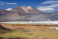
Salar de Atacama is the largest salt flat in Chile. It is located 55 km (34 mi) south of San Pedro de Atacama, is surrounded by mountains, and has no drainage outlets. In the east it is enclosed by the main chain of the Andes, while to the west lies a secondary mountain range of the Andes called Cordillera de Domeyko. Large volcanoes dominate the landscape, including the Licancabur, Acamarachi, Aguas Calientes and the Láscar. The last is one of the most active volcanoes in Chile. All of them are located along the eastern side of the Salar de Atacama, forming a generally north-south trending line of volcanoes that separate it from smaller endorheic basins.

Los Flamencos National Reserve is a nature reserve located in the commune of San Pedro de Atacama, Antofagasta Region of northern Chile. The reserve covers a total area of 740 square kilometres (290 sq mi) in the Central Andean dry puna ecoregion and consists of seven separate sections.
Salar de Aguas Calientes is the name of several salt flats in Chile:

Laguna Lejía is a salt lake located in the Altiplano of the Antofagasta Region of northern Chile. The landscape of the area is dominated by the volcanoes Chiliques, Lascar, Aguas Calientes and Acamarachi. It is shallow and has no outlet, covering a surface area of about 1.9 square kilometres (0.73 sq mi) in the present-day.

Salar de Carcote, also known as Salar de San Martín, is a salt flat in northern Chile. The salar is located southwest of Ollagüe. It covers an area of around 108 km2 and its surface elevation is 3,690 m. The landscape of the area is dominated by the volcanoes Ollagüe to the east and Aucanquilcha to the north. Salar de Carcote basin is bordered by the Loa River basin to the west and the Salar de Ascotán basin to the south.

The Central Andean dry puna (NT1001) is an ecoregion in the Montane grasslands and shrublands biome, located in the Andean high plateau, in South America. It is a part of the Puna grassland.

Cordón de Puntas Negras is a 500 km2 (193 sq mi) volcanic chain located east of the Salar de Atacama in Chile's Antofagasta Region.
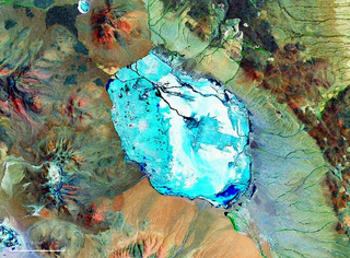
Pastos Grandes Lake is a lake in the Pastos Grandes caldera in the Potosí Department, Bolivia. At an elevation of 4,430 metres (14,530 ft), its surface area is 120 square kilometres (46 sq mi).

La Pacana is a Miocene age caldera in northern Chile's Antofagasta Region. Part of the Central Volcanic Zone of the Andes, it is part of the Altiplano-Puna volcanic complex, a major caldera and silicic ignimbrite volcanic field. This volcanic field is located in remote regions at the Zapaleri tripoint between Chile, Bolivia and Argentina.

Cerro Laguna Verde is one of the many stratovolcanoes that integrate a 180 km (112 mi)-long chain east of the Gran Salar de Atacama in Chile's II Region. The mountain is located 6 km (4 mi) west of Acamarachi and 12.5 km (8 mi) north of the Aguas Calientes (Simbad) and Lascar stratovolcanoes.

Chile Route 27 is a main road in the northern portion of Chile. It runs 156.19 km (97.05 mi) from San Pedro de Atacama to Paso de Jama. A short road off Route 27 heads north to Portezuelo del Cajón. Another adjacent road leads to Llano de Chajnantor Observatory, reaching maximum altitude of 5,064 metres (16,614 ft). The Chile Route 27 reaches an altitude according to OpenStreetMap of 4,831 metres (15,850 ft) at 23°04′21″S67°30′17″W at a road distance of 57.6 kilometres (35.8 mi) west of the border, making it one of the highest highways in South America.

Salar de Ascotán, also known as Salar de Cebollar, is a salt flat in northern Chile. Its drainage basin is 1,455 square kilometers (562 sq mi) and is shared with Bolivia. The basin is bordered on the north by the Salar de Carcote basin, on the east by small endorheic basins, including those of Laguna Cañapa and Laguna Hedionda, from which is separated by the crest of the Cerros de Cañapa, Cerro Araral and others. To the south, the basin is bordered by the San Pedro de Inacaliri River basin, while to the west the drainage divide between the salt flat and the Upper Loa River basin is marked by the summits of a chain of volcanoes culminating in Palpana.

Tuyajto Lake is a salt lake located in the Antofagasta Region, northern Chile. Located at an elevation of about 4,010 metres (13,160 ft), its surface area presently fluctuates between 1.7–2.7 square kilometres (0.66–1.04 sq mi) but in the past it was considerably larger; this led to humans going to the lake and creating archeological sites there. Presently, the lake is groundwater-fed and has no surface outlet but water might seep out underground. It is part of the Los Flamencos Natural Reserve.
Pastos Grandes is the name of a caldera and its crater lake in Bolivia. The caldera is part of the Altiplano-Puna volcanic complex, a large ignimbrite province that is part of the Central Volcanic Zone of the Andes. Pastos Grandes has erupted a number of ignimbrites through its history, some of which exceeded a volume of 1,000 cubic kilometres (240 cu mi). After the ignimbrite phase, the lava domes of the Cerro Chascon-Runtu Jarita complex were erupted close to the caldera and along faults.

Laguna del Negro Francisco is a lake in the Atacama Region of Chile and the southernmost closed lake in the country. It is situated 200 kilometres (120 mi) northeast of the city of Copiapó. The lake is about 10 kilometres (6.2 mi) long and 4 kilometres (2.5 mi) wide with a surface area of about 20.7 square kilometres (8.0 sq mi) and a depth of about 1 metre. A peninsula, probably formed by a moraine and subsequently modified by wind-driven accumulation of sand, separates the lake into a north-northwesterly and a south-southeasterly half with different colour and water composition.

Salar de Punta Negra is a saltpan in the Antofagasta Region of Chile with a surface area of about 230 square kilometres (89 sq mi). It is surrounded by deposits left by dry valleys that descend the Western Cordillera. These dry valleys, from mountains such as the Llullaillaco volcano, carry water only occasionally. More permanent sources of water, in the form of springs, also exist at Salar de Punta Negra.

Salar del Hombre Muerto is a salt pan in Argentina, in the Antofagasta de la Sierra Department on the border between the Salta and Catamarca Provinces. It covers an area of 600 square kilometres (230 sq mi) and is in part covered by debris. During the Pleistocene it was sometimes a lake, but today only parts of the salt pan are covered by perennial water bodies; its major tributary is the Rio de Los Patos.

Salar de Aguas Calientes IV is a salt pan in Chile. It is adjacent to the Llullaillaco National Park and is within the Central Andean dry puna ecoregion. Its drainage basin area is 536 km2 (207 sq mi).

Salar Ignorado is a salar in the Andes of Chile's Atacama Region at 4,250 metres (13,940 ft) elevation. Located just south of Cerro Bayo volcano, it comprises 0.7 square kilometres (0.27 sq mi) of salt flats, sand dunes and numerous pools of open water. The waters of Salar Ignorado, unlike these of other salt flats in the central Andes, are acidic owing to the input of sulfuric acid from hydrothermal water and the weathering of volcanic rocks.