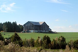
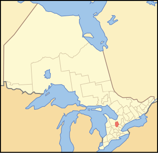
The Municipality of Trent Hills is a township municipality in Northumberland County in Central Ontario, Canada. It is on the Trent River and was created in 2001 through the amalgamation of the municipalities of Campbellford/Seymour, Percy Township and Hastings. Thereafter it was briefly known as Campbellford/Seymour, Percy, Hastings.

Salem is a compact rural community and unincorporated place in the incorporated township of Centre Wellington, Wellington County, in southwestern Ontario, Canada.

Fauquier-Strickland is a township municipality in Cochrane District in Northeastern Ontario, Canada. The three main communities in the township are Fauquier, Strickland, and Gregoires Mill. All are located along Ontario Highway 11 between the community of Departure Lake to the east and the municipality of Moonbeam to the west.

Val Rita-Harty is a township municipality in Cochrane District in Northeastern Ontario, Canada.

Chapple is a township municipality in Rainy River District in Northwestern Ontario, Canada.

Jogues is a dispersed rural community and unincorporated place in geographic Way Township, Cochrane District in Northeastern Ontario, Canada. It is about 11 kilometres (6.8 mi) southwest of Hearst. Jogues is also a designated place served by a local services board.

Coppell is a dispersed rural community and unincorporated place in geographic Lowther Township, Cochrane District in Northeastern Ontario, Canada. It is about 22 kilometres (14 mi) southwest of Hearst, and is counted as part of Unorganized Cochrane North Part in Canadian census data.

Batchawana Bay is an unincorporated place and Compact Rural Community in Algoma District in Northeastern Ontario, Canada. It is also the name of a local services board, consisting of parts of the geographic townships of Fisher, Herrick, Ryan and Tilley. It is located north of Sault Ste. Marie, Ontario, on the shores of Batchawana Bay off Lake Superior.

Mount Salem is a Dispersed Rural Community and unincorporated place in the municipal township of Malahide, Elgin County in southwestern Ontario, Canada. The community is in geographic Malahide Township at the intersection of Elgin County Road 40 and Elgin County Road 45, 7.8 kilometres (4.8 mi) southeast of the community of Aylmer.
Salem is a Dispersed Rural Community and unincorporated place in the municipality of South Bruce, Bruce County in southwestern Ontario, Canada. The community is in geographic Culross Township at the intersection of Bruce County Road 4 and Concession Road 12, 6 kilometres (3.7 mi) north of the community of Teeswater and 7 kilometres (4.3 mi) west of the community of Formosa, and is the location of a United Church built in 1872.
Salem is a locality and unincorporated place in the municipality of Clarington, Regional Municipality of Durham, in the Greater Toronto Area of Ontario, Canada.
Salem is a Compact Rural Community and unincorporated place in the municipality of South Frontenac, Frontenac County in southern Ontario, Canada. The community is in geographic Bedford Township, and lies on the county border with the municipality of Rideau Lakes, United Counties of Leeds and Grenville.
Salem is a Dispersed Rural Community and unincorporated place in the municipal township of Cramahe, Northhumberland County in southern Ontario, Canada. The community is on Northumberland County Road 2 about 4 kilometres (2.5 mi) east of Colborne and 9 kilometres (5.6 mi) west of Brighton.

Boon is a railway point and unincorporated place in geographic Templeton Township, Algoma District in Northeastern Ontario, Canada. The community is counted as part of Unorganized Algoma North Part in Canadian census data.
Hale is a Railway point and unincorporated place in geographic Templeton Township, Algoma District in Northeastern Ontario, Canada. The community is counted as part of Unorganized Algoma North Part in Canadian census data.

The Makobe River is a river in northeastern Ontario, Canada. It is in the Saint Lawrence River drainage basin and is a left tributary of the Montreal River.

Irvine Creek is a creek in the municipality of Centre Wellington, Wellington County in southwestern Ontario, Canada. It is in the Great Lakes Basin and is a right tributary of the Grand River.
Salem is a dispersed rural community and unincorporated place in the municipality of Arran–Elderslie, Bruce County in southwestern Ontario, Canada. The community is in geographic Elderslie Township at the intersection of Concession 10 Elderslie and Sideroad 15 South Elderslie, 10 kilometres (6.2 mi) northwest of the community of Chesley and 9 kilometres (5.6 mi) northeast of the community of Paisley. The community is on Snake Creek, a tributary of the Saugeen River.
Salem Creek is a stream in the municipal township of Cramahe, Northhumberland County in Central Ontario, Canada. It is in the Great Lakes Basin and is a tributary of Lake Ontario. The creek takes its name from the community of Salem which it flows past.
Jack Lake is a dispersed rural community and unincorporated place in the municipality of Havelock-Belmont-Methuen, Peterborough County in Central Ontario, Canada. The community is on the northwest shore of Jack Lake, in the Kawartha lakes region, and parts of the community extend to the west into the neighbouring municipality of North Kawartha. Jack Lake is reached by Peterborough County Road 52 / Jack Lake Road from the community of Apsley, about 5 kilometres (3.1 mi) to the north on Ontario Highway 28.