
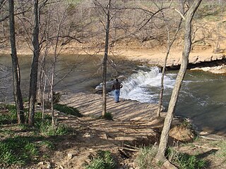
The Kern River, originally Rio de San Felipe, later La Porciuncula, is a river in the U.S. state of California, approximately 165 miles (270 km) long. It drains an area of the southern Sierra Nevada mountains northeast of Bakersfield. Fed by snowmelt near Mount Whitney, the river passes through scenic canyons in the mountains and is a popular destination for whitewater rafting and kayaking. It is the southernmost major river system in the Sierra Nevada, and is the only major river in the Sierra that drains in a southerly direction.
The Wakarusa River is a tributary of the Kansas River, approximately 80.5 miles (129.6 km) long, in eastern Kansas in the United States. It drains an agricultural area of rolling limestone hills south of Topeka and Lawrence.
The Pah Rah Range is a mountain range located in western Nevada in Washoe County just to the northeast of Reno. It is a hook shaped range with the main eastern portion oriented northwest-southeast, approximately 20 miles (32 km) long. The northwest flowing Cottonwood Creek in Warm Springs Valley is bounded on three sides by the range. To the south and east the Truckee River forms the boundary and Pyramid Lake is at the northeast. Spanish Springs Valley north of Reno forms the southwest margin. To the north the narrow Mullen Pass separates the Pah Rah Range from the Virginia Mountains.

The Clavey River is a tributary of the Tuolumne River in the Sierra Nevada, located in the Stanislaus National Forest and Tuolumne County, California. The river is 31.3 miles (50.4 km) long, and is one of the few undammed rivers on the western slope of the Sierra. Via the Tuolumne River, the Clavey is part of the San Joaquin River watershed.
Rancho La Brea was a 4,439-acre (17.96 km2) Mexican land grant in present-day Los Angeles County, California, given in 1828 to Antonio Jose Rocha and Nemisio Dominguez by José Antonio Carrillo, the alcalde of Los Angeles. Rancho La Brea consisted of one square league of land of what is now Wilshire's Miracle Mile, Hollywood, and parts of West Hollywood. The grant included the famous La Brea Tar Pits.

Pilot Peak is the highest mountain in the Pilot Range in extreme eastern Elko County, Nevada, United States. It is the most topographically prominent peak in Elko County and the fourth-most prominent peak in Nevada. The peak is on public land administered by the Bureau of Land Management and thus has no access restrictions.
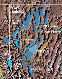
The Lahontan Valley is a basin in Churchill County, Nevada, United States. The valley is a landform of the central portion of the prehistoric Lake Lahontan's lakebed of 20,000-9,000 years ago. The valley and the adjacent Carson Sink represent a small portion of the lake bed. Humboldt Lake is to the valley's northeast. Pyramid Lake is west. Walker Lake is to the south.

Pacific Creek is a stream in the U.S. state of Wyoming. The approximately 36-mile (58 km) long stream rises on the western side of South Pass and flows into the Little Sandy Creek near Farson, Wyoming. As the name implies, the stream starts just to the west of the Continental Divide and so is on the "Pacific" side of the divide. The waters from the stream eventually flow into the Pacific Ocean via the Green River and Colorado River. The stream is a notable landmark on the Oregon, California and Mormon emigration trails.

Asphalto is a former settlement in Kern County, California. It was located on the railroad 3 miles (4.8 km) northeast of McKittrick, at an elevation of 932 feet. Asphalto still appeared on maps as of 1932.

Reward is an unincorporated community in western Kern County, California.

Coyote Creek is a principal tributary of the San Gabriel River in northwest Orange County, southeast Los Angeles County, and southwest Riverside County, California. It drains a land area of roughly 41.3 square miles (107 km2) covering five major cities, including Brea, Buena Park, Fullerton, La Habra, and La Palma. Some major tributaries of the creek in the highly urbanized watershed include Brea Creek, Fullerton Creek, and Carbon Creek. The mostly flat creek basin is separated by a series of low mountains, and is bounded by several small mountain ranges, including the Chino Hills, Puente Hills and West Coyote Hills.
Alamo Solo Spring, a spring directly east of the Dagany Gap in the Pyramid Hills of Kern County, California. Its location appears on a 1914 USGS Topographic map of Lost Hills.

Bitterwater Creek, formerly Arroyo de Amargosa, is a stream with its source just southwest of the southern extreme of the Elkhorn Hills, just west of and inside the San Luis Obispo County boundary, 6.3 miles southwest of Maricopa, California. The creek flows northwest to dissipate in the dry lake bed of Buena Vista Lake, 3.7 miles north of Pentland, Kern County, California. In years of heavy rainfall it would be a tributary to Buena Vista Lake, which has been dry for many years due to agricultural diversion.
Bitterwater Creek, originally named Arroyo de Matarano, is a stream in eastern San Luis Obispo County and northwestern Kern County, central California.
Devilwater Creek, originally Arroyo Del Diablo, a stream with its source on the east slope of the Temblor Range in Kern County, California, that flows northeast to terminate just a mile west southwest of the mouth of Media Aqua Creek. It was officially named Devilwater Creek in 1909.
Temblor Creek, formerly Arroyo de Los Temblores, is a stream with its source on the east slope of the Temblor Range, California, United States. It flows east-northeast to its confluence with Salt Creek in the Temblor Valley, 44 miles west of Bakersfield in Kern County, California.
Mud Spring, formerly called Aquaje Lodoso, is a spring and historic site in the western Antelope Valley, within northern Los Angeles County, southern California.
Cottonwood Creek, is a stream in Kern County, California. Its headwaters are located on the eastern slopes of the Tehachapi Mountains, near a spring 2 miles northwest of the Libre Twins peak. It flows east then southeast into Antelope Valley in the western Mojave Desert.
La Vereda del Monte was a backcountry route through remote regions of the Diablo Range, one of the California Coast Ranges. La Vereda del Monte was the upper part of La Vereda Caballo,, used by mesteñeros from the early 1840s to drive Alta California horses to Sonora for sale.
Aguaje is a Spanish word with several meanings related to water. When used for its meaning as a watering place, aguaje is a geographic locale which can be a spring, a stream, arroyo or other natural water feature or a well that reliably provides water for people and their livestock. When used for a natural watering place, the word "abrevadero,", is sometimes used instead.

