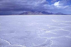
Salt flats, Salt flat, Salt Flats, or Salt Flat may refer to:
Hudspeth County is a county located in the U.S. state of Texas. As of the 2020 census, the population was 3,202. Its county seat is Sierra Blanca, and the largest community is Fort Hancock. The county is named for Claude Benton Hudspeth, a state senator and United States Representative from El Paso. It is northeast of the Mexico–U.S. border.
Grand Saline is a city in Van Zandt County, Texas, United States, located in East Texas. The population was 3,107 as of 2020, making Grand Saline the third-largest city in Van Zandt County. The city is located roughly 75 miles (120 km) east of Dallas and 35 miles (56 km) northwest of Tyler, the two nearest metropolitan areas, and is part of the greater Tyler/Longview area.
Salar de Uyuni is the world's largest salt flat, or playa, at over 10,000 square kilometres (3,900 sq mi) in area. It is in the Daniel Campos Province in Potosí in southwest Bolivia, near the crest of the Andes at an elevation of 3,656 m (11,995 ft) above sea level.
A groom is a male participant in a wedding ceremony.
Terrace may refer to:
A dry lake bed, also known as a playa, is a basin or depression that formerly contained a standing surface water body, which disappears when evaporation processes exceed recharge. If the floor of a dry lake is covered by deposits of alkaline compounds, it is known as an alkali flat. If covered with salt, it is known as a salt flat.
Rocky Mountain oysters or mountain oysters, or meat balls, also known as prairie oysters in Canada, is a dish made of bull testicles. The organs are often deep-fried after being skinned, coated in flour, pepper and salt, and sometimes pounded flat. The dish is most often served as an appetizer.
A sombrero is a type of wide-brimmed Mexican men's hat used to shield the face and eyes from the sun. It usually has a high pointed crown, an extra-wide brim that is slightly upturned at the edge, and a chin strap to hold it in place.
The Bonneville Salt Flats are a densely packed salt pan in Tooele County in northwestern Utah. A remnant of the Pleistocene Lake Bonneville, it is the largest of many salt flats west of the Great Salt Lake. It is public land managed by the Bureau of Land Management and is known for land speed records at the Bonneville Speedway. Access to the Flats is open to the public.
El Capitan is a peak in Culberson County, Texas, located within Guadalupe Mountains National Park. The 10th-highest peak in Texas at 8,085 ft, El Capitan is part of the Guadalupe Mountains, an exposed portion of a Permian period reef uplifted and exposed by tectonic activity during the late Cretaceous period. The southern terminus of the Guadalupe Mountains, El Capitan looms over U.S. 62/180, where its imposing height and stark outline have made it one of the iconic images of the Trans-Pecos to generations of travelers.
Salt pans can refer to:
Kosher salt or kitchen salt is coarse edible salt without common additives such as iodine. Typically used in cooking and not at the table, it consists mainly of sodium chloride and may include anticaking agents.
Salt of the earth is a phrase used by Jesus, according to the New Testament. It may refer to:
The Yearning for Zion Ranch, or the YFZ Ranch, was a 1,700-acre (690-hectare) Fundamentalist Church of Jesus Christ of Latter-Day Saints (FLDS) community of as many as 700 people, located near Eldorado in Schleicher County, Texas, United States. In April 2014, the State of Texas took physical and legal possession of the property.
A sabkha is a coastal, supratidal mudflat or sandflat in which evaporite-saline minerals accumulate as the result of semiarid to arid climate. Sabkhas are gradational between land and intertidal zone within restricted coastal plains just above normal high-tide level. Within a sabkha, evaporite-saline minerals sediments typically accumulate below the surface of mudflats or sandflats. Evaporite-saline minerals, tidal-flood, and aeolian deposits characterize many sabkhas found along modern coastlines. The accepted type locality for a sabkha is at the southern coast of the Persian Gulf, in the United Arab Emirates. Sabkha is a phonetic transliteration of the Arabic word used to describe any form of salt flat. A sabkha is also known as a sabkhah,sebkha, or coastal sabkha.
The El Paso Metropolitan Statistical Area, as defined by the United States Census Bureau, is an area consisting of two counties – El Paso and Hudspeth – in far West Texas, anchored by the city of El Paso. As of the 2020 United States Census, the MSA had a population of 868,859. The El Paso MSA forms part of the larger El Paso–Las Cruces combined statistical area, with a total population of 1,088,420 as of the 2020 United States Census.
Paulville, Texas, was an American cooperative organization as well as the site and planned community under its development in the salt flats of north Hudspeth County, intended to consist exclusively of Ron Paul supporters. The Paulville community was named after the U.S. Congressman and established in January 2008 following the rise in popularity of his 2008 campaign. The cooperative was modeled on Paul's often libertarian ideas. The site was never developed, and the organization is now inactive.
Salt Flat is a ghost town in northeastern Hudspeth County, Texas, United States. It lies along the concurrent U.S. Routes 62 and 180 north of the Census-designated place (CDP) of Sierra Blanca, the county seat of Hudspeth County. Its elevation is 3,730 feet (1,137 m). Although Salt Flat is unincorporated, it has a ZIP Code of 79847. The headquarters of the nearby Guadalupe Mountains National Park uses this ZIP Code although it is located closer to Pine Springs, which has no post office.
Pilgrim, Texas is located in Gonzales County, Texas and has a population of approximately sixty. Pilgrim is situated on land granted to Thomas J. Pilgrim by Stephen F. Austin. Pilgrim, TX is located near a salt flat, and was a notable hideout for John Wesley Hardin in the 1870s. A map shows Pilgrim is located on Farm to Market Road 1116.
The Salt Fork Brazos River is a braided, highly intermittent stream about 150 mi (240 km) long, heading along the edge of the Llano Estacado about 26 mi (42 km) east-southeast of Lubbock, Texas. From its source, it flows generally east-southeastward to join the Double Mountain Fork to form the Brazos River about 18 mi (29 km) west-northwest of Haskell, Texas. The Salt Fork stretches across portions of Crosby, Garza, Kent, and Stonewall counties of West Texas.