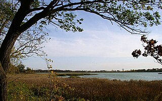
Salui is a small fishing village on the western shore of Lake Malawi. In 2011, the population of the village was estimated at 800.
The village consists of an estimated 100 straw and mud-straw huts of traditional Malawian construction separated into three small groups by drainage or irrigation areas. Dugout canoe-type boats are used by the local fishermen, as well as fishing barrier/walls and nets for communal or group fishing. A single Baptist church serves the village. As of June 2011 the church pastor was Abusa (Pastor) Nathan.
The villagers grow rice, sugar cane, and corn using water from Lake Malawi. The soil is sandy at the beach area, but turns to a clay/loam within a few hundred meters of the shoreline, enabling the creation of patties for rice growth.
The village is accessible by an improved, single-lane dirt road which extends east from the two-lane, asphalt-surface route M5. The M5 serves as a major artery between the two larger town/cities nearby; Salima to the south, and Mzuzu to the north.[1]
The village does not have access to electricity or running water. Salui is home to many orphaned children, most likely as a result of a large number of adult deaths due to HIV infection.
Notes
↑ Palin, Michael. Malawi: a Bradt Travel Guide. The Globe Pequot Press Inc., 2010, p.109.
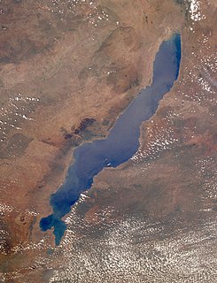
Lake Malawi, also known as Lake Nyasa in Tanzania and Lago Niassa in Mozambique, is an African Great Lake and the southernmost lake in the East African Rift system, located between Malawi, Mozambique and Tanzania.
The Zambezi River is the fourth-longest river in Africa, the longest east-flowing river in Africa and the largest flowing into the Indian Ocean from Africa. The area of its basin is 1,390,000 square kilometres (540,000 sq mi), slightly less than half of the Nile's. The 2,574-kilometre-long river (1,599 mi) arises in Zambia and flows through eastern Angola, along the north-eastern border of Namibia and the northern border of Botswana, then along the border between Zambia and Zimbabwe to Mozambique, where it crosses the country to empty into the Indian Ocean.
Fife Lake, is a village in Grand Traverse County in the U.S. state of Michigan. The population was 443 at the 2010 census.
Lakeville is the largest city in Dakota County, Minnesota, United States. It is a suburb of Minneapolis-Saint Paul, approximately 20 miles (32 km) south of both downtown Minneapolis and downtown St. Paul along Interstate Highway 35. Lakeville is one of the fastest-growing cities in the Twin Cities area. The U.S. Census Bureau estimated its population to be 67,317 in 2019.
The British Central Africa Protectorate (BCA) was a British protectorate proclaimed in 1889 and ratified in 1891 that occupied the same area as present-day Malawi: it was renamed Nyasaland in 1907. British interest in the area arose from visits made by David Livingstone from 1858 onward during his exploration of the Zambezi area. This encouraged missionary activity that started in the 1860s, undertaken by the Universities' Mission to Central Africa, the Church of Scotland and the Free Church of Scotland, and which was followed by a small number of settlers. The Portuguese government attempted to claim much of the area in which the missionaries and settlers operated, but this was disputed by the British government. To forestall a Portuguese expedition claiming effective occupation, a protectorate was proclaimed, first over the south of this area, then over the whole of it in 1889. After negotiations with the Portuguese and German governments on its boundaries, the protectorate was formally ratified by the British government in May 1891.
Zomba is a city in southern Malawi, in the Shire Highlands. It is the former capital city of Malawi.
The African Great Lakes are a series of lakes constituting the part of the Rift Valley lakes in and around the East African Rift. They include Lake Victoria, the second-largest fresh water lake in the world by area, Lake Tanganyika, the world's second-largest freshwater lake by volume and depth, and Lake Malawi, the world's eighth-largest fresh water lake by area. Collectively, they contain 31,000 km3 of water, which is more than either Lake Baikal or the North American Great Lakes. This total constitutes about 25% of the planet's unfrozen surface fresh water. The large rift lakes of Africa are the ancient home of great biodiversity, and 10% of the world's fish species live in this region.
Lake Maninjau is a caldera lake in West Sumatra, Indonesia. It is located 36 kilometres (22 mi) to the west of Bukittinggi, at 0°19′S100°12′E.
The Tanganyika sardine is known as kapenta or matemba in Zambia, Malawi and Zimbabwe. Kapenta is two species, both of which are small, planktivorous, pelagic, freshwater clupeid originating from Lake Tanganyika in Zambia. They form the major biomass of pelagic fish in Lake Tanganyika and Lake Malawi, swimming in large schools in the open lake, feeding on copepods and potentially jellyfish. Their major predators are four species of Lates which are also endemic to Lake Tanganyika, and are related to the Nile perch in Lake Victoria. All of these pelagic fish have suffered from overfishing in the last two decades.
Nkhotakota (Un-kho-tah-kho-tuh) is a town and one of the districts in the Central Region of Malawi. It is on the shore of Lake Malawi and is one of the main ports on Lake Malawi. As of 2018, Nkhotakota had a population estimated at 28,350. The district had a population of 301.000.
Lake Koshkonong is naturally occurring lake that acts as a reservoir in southern Wisconsin. Its size was augmented by the creation of the Indianford Dam in 1932, making it one of the larger lakes in the state. The lake lies along the Rock River, with the river acting as both the primary inflow and the primary outflow for the lake. Lake Koshkonong begins 5.5 mi (8.9 km) downriver from Fort Atkinson, with the large majority of the lake located in southwestern Jefferson County. Small portions of the lake extend into southeastern Dane and northern Rock counties.
Likoma Island is the larger of two inhabited islands in Lake Malawi, in East Africa, the smaller being the nearby Chizumulu. Likoma and Chizumulu both belong to Malawi, and together they make up the Likoma District. Although both islands lie just a few kilometres from Mozambique, and are entirely surrounded by Mozambican territorial waters, they are both exclaves of Malawi.
Inle Lake, a freshwater lake located in the Nyaungshwe Township of Shan State, part of Shan Hills in Myanmar (Burma). It is the second largest lake in Myanmar with an estimated surface area of 44.9 square miles (116 km2), and one of the highest at an elevation of 2,900 feet (880 m). During the dry season, the average water depth is 7 feet (2.1 m), with the deepest point being 12 feet (3.7 m). During the rainy season, this can increase by 5 feet (1.5 m).
The Indus River Delta, forms where the Indus River flows into the Arabian Sea, mostly in the southern Sindh province of Pakistan with a small portion in the Kutch Region of the western tip of India. The delta covers an area of about 41,440 km2, and is approximately 210 km (130 mi) across where it meets the sea. The active part of the delta is 6,000 km2 in area (2,300 sq mi). The climate is arid, the region only receives between 25 and 50 centimetres of rainfall in a normal year. The delta is home to the largest arid mangrove forests in the world, as well as many birds, fish and the Indus dolphin.
Rice Lake State Park is a state park of Minnesota, United States, just east of Owatonna. Park lands entirely surround Rice Lake, an important stopping point for migrating waterfowl. The lake covers 750 acres (300 ha) with an average depth of 3 feet (1 m).
Lake Malawi National Park is a national park at the southern end of Lake Malawi in Malawi, Southeast Africa. It is the only national park in Malawi that was created with the purpose of protecting fish and aquatic habitats. Despite this being its main purpose, Lake Malawi National Park includes a fair amount of land, including a headland, the foreshore and several small rocky islands in Lake Malawi.
A fishing village is a village, usually located near a fishing ground, with an economy based on catching fish and harvesting seafood. The continents and islands around the world have coastlines totalling around 356,000 kilometres (221,000 mi). From Neolithic times, these coastlines, as well as the shorelines of inland lakes and the banks of rivers, have been punctuated with fishing villages. Most surviving fishing villages are traditional.
Henfield is a hamlet in South Gloucestershire, England between Coalpit Heath and Westerleigh, adjoining the hamlet of Ram Hill immediately to the north.
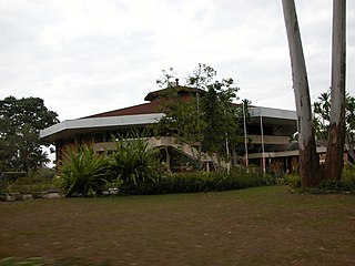
The Gospelink Agricultural Training Center is an outreach and mission center along Lake Malawi in the Salima District of Malawi.
Nancy Lake State Recreation Area is a 22,685 acres (9,180 ha) park near Willow in the Matanuska-Susitna Borough of Alaska. Founded on July 6, 1966 and set aside specifically for recreational use, the park is home to more than a hundred lakes as well as extensive wetlands. The landscape of the park was crafted in glacial retreats around 9,000 years ago, and around this same time the first inhabitants likely moved into the area. They were eventually followed by Russian exploration, and later increases in white settlement due to commerce and the presence of gold.
This page is based on this Wikipedia article Text is available under the CC BY-SA 4.0 license; additional terms may apply. Images, videos and audio are available under their respective licenses.