
The Salzungen Werra Upland (German : Salzunger Werrabergland) is a natural region in Germany that forms part of the East Hesse Highlands in the German states of Hesse and Thuringia.
The Salzungen Werra Upland (German : Salzunger Werrabergland) is a natural region in Germany that forms part of the East Hesse Highlands in the German states of Hesse and Thuringia.
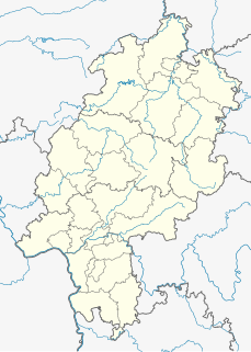
The Salzungen Werra Upland lies on either side of the Werra near Bad Salzungen. It has a plateau-like character, lies at a height of between 350 and 645.4 m above sea level (NN) and extends from the northwestern Thuringian Forest (to the east), to the Kuppen Rhön (to the west) and the forest of Seulingswald (to the northwest). It accompanies the River Werra on both sides from Walldorf to Vacha, continuing on its right bank only as far as Gerstungen.
The upland's main rock is bunter sandstone, from which emerge several, less volcanic kuppen like the Pleß and Stoffelskuppe, whose phenotype presages the Kuppen Rhön that lies to the west. Salt tectonics have resulted in hollows and sinkholes.
The Salzungen Werra Upland is a major natural region unit (no. 359) within the major unit group of the East Hesse Highlands (number 35 or D47). The valleys of the Werra and Suhl, which mainly run in a northwesterly direction, divide the upland into 3 orographic mountain regions, of which only the central Frauensee Hills (Frauenseer Hügelland) are independent. [1]
359 Salzungen Werra Upland (Salzunger Werrabergland)
Among the mountains and hills of the Salzungen Werra Upland are the following − with heights in metres above sea level (NN):
|
|
Among the rivers and streams (all in the Werra catchment) of the Salzungen Werra Upland are the following (downstream from south to north, with lengths in kilometres and mouth locations):
Left tributaries of the Werra:
| Right tributaries of the Werra:
|

The Rhön Mountains are a group of low mountains in central Germany, located around the border area where the states of Hesse, Bavaria and Thuringia come together. These mountains, which are at the extreme southeast end of the East Hesse Highlands, are partly a result of ancient volcanic activity. They are separated from the Vogelsberg Mountains by the river Fulda and its valley. The highest mountain in the Rhön is the Wasserkuppe which is in Hesse. The Rhön Mountains are a popular tourist destination and walking area.

Frauensee is a village and a former municipality in the Wartburgkreis district of Thuringia, Germany. Since July 2018, it is part of the town Bad Salzungen.
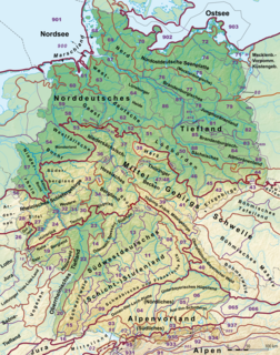
This division of Germany into major natural regions takes account primarily of geomorphological, geological, hydrological, and pedological criteria in order to divide the country into large, physical units with a common geographical basis. Political boundaries play no part in this, apart from defining the national border.

The West Hesse Highlands, also known as the West Hessian Lowlands and Highlands, refers to a heavily forested region of the Central Uplands in Germany that lies mostly within the state of Hesse, between those elements of the Rhenish Massif right of the Rhine in the west, the Weser Uplands to the north, the Hessian Central Uplands to the east and the Wetterau to the south.
The East Hesse Highlands describes a heavily wooded range of hills lying mainly in the German state of Hesse, but also extending a little way into Lower Saxony to the north, Thuringia to the east and Bavaria to the southeast. The region is sandwiched between the West Hesse Depression to the west, the Weser Uplands to the north, the Thuringian Basin to the northeast, the northwestern edge of the Thuringian Forest to the east, the Spessart to the south and the Wetterau to the southwest.

The Gladenbach Uplands, named after their central town of Gladenbach, is a range of hills up to 609 m high in the Rhine Massif in Germany, on the junction of the Rothaar Mountains, Westerwald (southwest), (Eastern) Hintertaunus and West Hesse Highlands in the east. It lies in Central Hesse within the districts of Marburg-Biedenkopf, Lahn-Dill and Gießen within the so-called Lahn-Dill-(Dietzhölze-) loop. Small parts of the Upper Lahn Valley in the northwest belong, together with the town of Bad Laasphe, also to the district of Siegen-Wittgenstein, North Rhine-Westphalia.
The Waldeck Plateau is a natural 'upper main unit' in the German state of Hesse between the rivers Eder and Diemel, the East Sauerland Hills in the west and the East Waldeck Basin in the east.

The High Fichtel Mountains, or High Fichtel, form a mountainous and heavily forested range consisting of several mountain chains in the shape of a horseshoe, the Fichtel Mountain Horseshoe (Fichtelgebirgs-Hufeisen), that rings the Selb-Wunsiedel Plateau.
The Central Rhön is a 5th level natural region which, together with the Southern High Rhön, forms the High Rhön. The region has several mountains over 900 metres high, including: the Wasserkuppe (950.0 m) and Heidelstein (926 m). Other summits over 900 metres are regarded as subpeaks due to their low isolation and prominence.

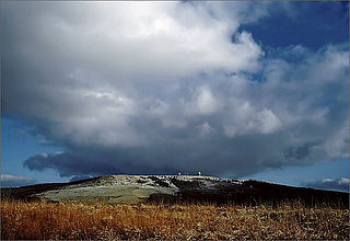
The Pleß is a mountain, 645.4 m above sea level (NHN), in the county of Schmalkalden-Meiningen in the Salzungen Werra Highland in the German state of Thuringia.
The Wasserkuppen Rhön or Wasserkuppenrhön, named after its highest peak, also the highest summit in the entire Rhön Mountains, the Wasserkuppe, is an exposed highland ridge and natural region in the Hessian county of Fulda and Bavarian county of Rhön-Grabfeld. Together with the Long Rhön and its eastern flank it forms the Central Rhön. The Red Moor lies within this natural region.

The Long Rhön is a ridge in the Central Rhön which forms part of the High Rhön within the Rhön Mountains. The Long Rhön is an elongated basalt plateau in the centre, roughly 800 metres above sea level, which is only occasional interrupted by mountain peaks. Its highest mountain is the Heidelstein. A majority of the area is part of the Long Rhön Nature Reserve. In this area of the Rhön is the Black Moor.
The Moselle Eifel forms the southeastern strip of the East Eifel to the left of the Moselle from the city of Trier downstream as far as Moselkern; in the southeast it does not reach as far as the Moselle Valley. It lies exclusively within the German state of Rhineland-Palatinate and is a truncated highland, roughly half of which is forested.
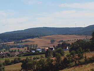
The Seulingswald is a hill range in the German Central Uplands which reaches heights of up to 480.3 m above sea level (NHN). It is part of the Fulda-Werra Uplands in the East Hesse Highlands within the Hessian county of Hersfeld-Rotenburg; small ridges extend into the Thuringian county of Wartburgkreis. It is a sandstone range and one of the largest contiguous woodland areas in Hesse.
The Fulda-Werra Uplands are a major natural regional unit in the East Hesse Highlands in East and North Hesse and, with small elements in the southeast, in the German state of Thuringia. Most of the range lies right of the River Fulda and left of the Werra. The uplands extend from the Rhön mountains northwards, to the River Weser near Hann. Münden.
The Söhre is a forested hill range of the German Central Uplands and a subordinate natural region of the Fulda-Werra Uplands in North Hesse, Germany.

The Middle Rhine Basin is the central landscape region of the Middle Rhine in Germany and, along with the Limburg Basin, forms one of the biggest intra-montane lowland regions within the Rhenish Massif. The basin is divided into the valley bottom of the Neuwied Basin, the Neuwied Basin Perimeter east of the Rhine and the Lower Moselle Valley west of the Rhine in the south, and the Maifeld-Pellenz Hills in the north.
As well as being a low mountain range, the Westerwald is also a natural region in the system of natural regional division of Germany. Within that it is a major unit group with the number "32". According to this system the major unit group of the Westerwald belongs to the basement plate (Grundgebirgsschollenland), which describes the type of mountain-building process by which it was formed. The major unit group extends across the states of Hesse, North Rhine-Westphalia and Rhineland-Palatinate. It is roughly bounded by the valleys of the Lahn, Rhine and Sieg, whereby the hills immediately south of the Heller and Sieg are not considered to be part of it.

The Rhön Cycleway is a cycle path in Germany that runs for 180 kilometres from Bad Salzungen to Hammelburg. Its route takes it through 3 states: from Thuringia via Hesse to Bavaria.