Samalae'ulu

Last updated
Samalae'ulu inland and the south east of the black lava fields along the coastline. (NASA photo, 2009 ISS018-E-38802 NASA northeast coast Savai'i Samauga, Samalaeulu, Patamea.jpg
Samalae'ulu inland and the south east of the black lava fields along the coastline. (NASA photo, 2009

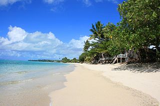
Samalae'ulu is a village on the northeast side of Savai'i island in Samoa. [1] The village is part of the electoral constituency (Faipule District) Gaga'emauga I which includes the neighbouring villages of Patamea and the smaller settlement of Mauga which is built around a volcanic crater.

Savaii island

Savaiʻi is the largest and highest island in Samoa and the Samoan Islands chain. The island is the fifth largest in Polynesia, behind the two main islands of New Zealand and the Hawaiian Islands of Hawaii and Maui.

Samoa country in Oceania

Samoa, officially the Independent State ofSamoa and, until 4 July 1997, known as Western Samoa, is a country consisting of two main islands, Savai'i and Upolu, and four smaller islands. The capital city is Apia. The Lapita people discovered and settled the Samoan Islands around 3,500 years ago. They developed a unique Samoan language and Samoan cultural identity.

Patamea Village in Gagaemauga, Samoa

Patamea is a village on the island of Savai'i in Samoa. While most villages on Savai'i are situated near the sea, Patamea is situated inland, away from the coast. The village is in the Gaga'emauga political district near the central north coast of the island.

The population of Samalae'ulu is 943 (2006 Census), making it one of the more populous villages in Savai'i. [2]

During the volcani eruption of Mt Matavanu (1905 - 1911), lava flowed between Samalae'ulu and Saleaula to the west, forcing villagers to move from the coast to its present inland location.

Saleaula Village in Gagaemauga, Samoa

Sale'aula is a village on the central north coast of Savai'i island in Samoa and is the traditional center of the Gaga'emauga political district. Chief council meetings are held at Vaitu’utu’u malae in the village.

The village is situated on the main island highway about a 40-minutes drive north west from Salelologa ferry terminal and township.

Salelologa Township & Ferry Terminal in Faasaleleaga, Samoa

Salelologa is a village district at the east end of Savai'i island in Samoa. It is the main entry point into the island with the only ferry terminal on Savai'i. It also serves as the main township for shopping and public amenities with a market selling fresh produce and arts and crafts.

Related Research Articles

Sataua is a village on the island of Savai'i in Samoa. It is situated at the northwestern end of the island in the district of Vaisigano.

Sala'ilua is a village on the island of Savai'i in Samoa. It is situated on the south coast of the island in Palauli district.

Lalomalava is a village at the southeast end of Savai'i island in Samoa. The village is part of the electoral constituency Fa'asaleleaga I which is within the larger political district (Itumalo) of Fa'asaleleaga.

Gataivai is a village on the island of Savai'i in Samoa. It is situated on the south east coast of the island in Palauli district.

Puleia is a village on the island of Savai'i in Samoa. It is situated on the south coast of the island in Palauli district.

Tufutafoe is a village on the island of Savai'i in Samoa. It is situated on the west coast of the island in Vaisigano district.

Vaega is a village on the island of Savai'i in Samoa. It is situated on the south coast of the island in the political district of Satupa'itea.

Salelavalu Tai is a village at the east end of Savai'i island in Samoa. The village is part of the electoral constituency Fa'asaleleaga I which is within the larger political district (Itumalo) of Fa'asaleleaga.

Salelavalu Uta is a village at the east end of Savai'i island in Samoa. The village is part of the electoral constituency Fa'asaleleaga I which is within the larger political district (Itumalo) of Fa'asaleleaga.

Vaimaga is a village at the east end of Savai'i island in Samoa. The village is part of the electoral constituency Fa'asaleleaga II which is within the larger political district (Itumalo) of Fa'asaleleaga.

Sa'asa'ai is a village at the east end of Savai'i island in Samoa. The village is part of the electoral constituency Fa'asaleleaga III which is within the larger political district (Itumalo) of Fa'asaleleaga.

Saipipi is a village at the east end of Savai'i island in Samoa. The village is part of the electoral constituency Fa'asaleleaga III which is within the larger political district (Itumalo) of Fa'asaleleaga.

Lano, Samoa village on the island of Savaii

Lano is a village on the north east coast of Savai'i island in Samoa. The village is part of the electoral constituency Fa'asaleleaga IV which is within the larger political district (Itumalo) of Fa'asaleleaga.

Pu'apu'a is a village on the north east coast of Savai'i island in Samoa. The village is part of the electoral constituency Fa'asaleleaga IV which is within the larger political district (Itumalo) of Fa'asaleleaga.

Fogapoa is a village on the north east coast of Savai'i island in Samoa. The village is part of the electoral constituency Fa'asaleleaga II which is within the larger political district (Itumalo) of Fa'asaleleaga.

Avao

Avao is a village on the north central coast of Savai'i island in Samoa. The village is part of the electoral constituency Gaga'emauga III, which is included in the larger political district of Gaga'emauga.

Lelepa, Samoa Samaoan island

Lelepa is a village on the north central coast of Savai'i island in Samoa. The village is part of the electoral constituency Gaga'emauga III which forms part of the larger political district of Gaga'emauga.

Saleia is a village on the north central coast of Savai'i island in Samoa. The village is part of the electoral constituency Gaga'emauga III which forms part of the larger political district of Gaga'emauga.

Safa'i is a village on the north central coast of Savai'i island in Samoa. The village is part of the electoral constituency Gaga'emauga III which forms part of the larger political district Gaga'emauga.

References

  1. "Samoa Territorial Constituencies Act 1963". Pacific Islands Legal Information Institute. Archived from the original on 5 June 2011. Retrieved 19 December 2009.
  2. "Population and Housing Census Report 2006" (PDF). Samoa Bureau of Statistics. July 2008. Archived from the original (PDF) on 21 July 2011. Retrieved 19 December 2009.

Coordinates: 13°30′10″S172°18′00″W / 13.50278°S 172.30000°W / -13.50278; -172.30000

Geographic coordinate system Coordinate system

A geographic coordinate system is a coordinate system that enables every location on Earth to be specified by a set of numbers, letters or symbols. The coordinates are often chosen such that one of the numbers represents a vertical position and two or three of the numbers represent a horizontal position; alternatively, a geographic position may be expressed in a combined three-dimensional Cartesian vector. A common choice of coordinates is latitude, longitude and elevation. To specify a location on a plane requires a map projection.