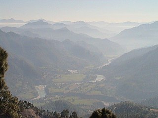
Kumaon is a revenue and administrative division in the Indian State of Uttarakhand. It spans over the eastern half of the state and is bounded on the north by Tibet, on the east by Nepal, on the south by the state of Uttar Pradesh, and on the west by Garhwal. Kumaon comprises six districts of the state: Almora, Bageshwar, Champawat, Nainital, Pithoragarh and Udham Singh Nagar.

Mahakali was one of the fourteen zones located in the Far-Western Development Region of Nepal, covering an area of 6,205 km2 in the westernmost part of the country. It stretches along Nepal's far western border with India, marked by the Kali River or Mahakali River.

Baitadi District, historical name “Bairath” (बैराथ), a part of Sudurpashchim Province, is one of the 77 districts of Nepal. It is a Hill district. Baitadi, with Dasharathchand as its headquarters, covers an area of 1,519 km2 (586 sq mi) and has a population of 250,898 according to the census (2011). The Baitadi district entails 56 village development councils (VDCs) and two municipality in the past. Now, by federal policy there are 10 local units; 4 Municipalities and 6 Rural Municipalities. Baitadi falls into the farthest western regional district of Nepal touching Jhulaghat, India, Nepal's neighboring country, to its border.

Darchula District is one of the nine districts of Sudurpashchim Province. The area, with Khalanga as its capital, covers an area of 2,322 km2 (897 sq mi) and has a population (2011) of 133,274. Darchula lies in the west-north corner of the country.

Doti District, part of Sudurpashchim Province, is one of the 77 districts of Nepal. This district, with Silgadhi as its headquarters, covers an area of 2,025 square kilometres (782 sq mi) with a population of 207,066 in 2001 and increasing marginally to 211,746 in 2011.

Didihat is a town and a Nagar Palika in Pithoragarh District in the state of Uttarakhand, India. It is one of the eleven administrative subdivisions of Pithoragarh district and also serves as its administrative headquarter. With a population of 6522, Didihat is located at a distance of 415 km (258 mi) from the state capital Dehradun.

Askot or Askote is a small Himalayan town in Pithoragarh district of Uttarakhand in India. It is the part of Kanalichhina development Block and Didihat Tehsil.

The Chand dynasty was a Hindu Rajput dynasty that ruled the Kumaon area in present-day Uttarakhand state of India, after the decline of the Katyuri rule. At times, their rule also extended to the western parts of present-day Nepal. Somchand established the dynasty, establishing his capital at Rajbunga in present-day Champawat.

Doti, also known as Dotigarh (डोटीगढ़) or the Far-Western Development Region was a development region of Nepal situated between River Kali bordering Kumaon division of Uttarakhand, India in the west and the Karnali river on the east. Doti was one of eight different princely states of the Katyuri Kingdom.

Pithoragarh is a Himalayan town with a Municipal corporation in Pithoragarh district in the Indian state of Uttarakhand. It is the largest hill town in Kumaon Division.

Lohaghat is a town and a nagar palika in Champawat district in the Indian state of Uttarakhand. Lohaghat is also famous for its various cultural events like Holi Rang Mahotsav, Devidhar Mela ,etc. Most special thing regarding Lohaghat is the Ramleela of Lohaghat which is one of the oldest Ramleela of Kumaoun Division.

Baijnath is a small town on the banks of the Gomati river in the Bageshwar district in Kumaon division of Uttarakhand, India. The place is most noted for its ancient temples, which have been recognized as Monuments of National Importance by the Archaeological Survey of India in Uttarakhand. Baijnath has been selected as one of the four places to be connected by the 'Shiva Heritage Circuit' in Kumaon, under the Swadesh Darshan Scheme of the Government of India.
The Katyuri kings were a medieval Hindu ruling clan of Khasa origin that ruled over the regions in Uttarakhand in India and western Nepal from 700 to 1200 CE. The founder of this dynasty, King Vasu Dev was originally a Buddhist ruler, but later he started following Hindu practices sometimes attributed to a vigorous campaign of Hindu philosopher Adi Shankara.

The Far-Western Development Region was one of Nepal's five development regions. It was located at the western end of the country and had its headquarters in Dipayal.

Kumaon Kingdom was an independent Himalayan kingdom in Kumaon, a region located in the eastern part of the present-day Uttarakhand state of India. It was established around 7th century and remained an independent and sovereign kingdom until 1791.
Sawad is a historical region in present-day southern Iraq.

Sudurpashchim Province is one of the seven provinces established by the new constitution of Nepal which was adopted on 20 September 2015. It borders the Tibet Autonomous Region of China to the north, Karnali Province and Lumbini Province to the east, and India's states of Uttarakhand and Uttar Pradesh to the west and south, respectively. The province covers an area of 19,999.28 km2, or about 13.55% of the country's total area.
The Thakuri is a Royal caste forming the core of the ruling class in Nepal. This term is a Nepali adaptation of the Indian title Thakur, which translates to 'master of the estate'. The term denotes the royal descendants of kings of Khasa Kingdom, Gandaki kingdom and the Kingdom of Nepal.

Ajaymerukot (Nepali:अजयमेरुकोट) was one of the capital of Doti kingdom established by the Malla kings in 13th century. The ruins of the palace is located in Ajaymeru Rural Municipality in Dadeldhura district which about 3.3 km away from Dadeldhhura, Nepal.
Rajwar was a title used by the Katyuri Kings and Chand Rajput community of Kumaon.


