
Tumakuru district is an administrative district in the state of Karnataka in India. It is the third largest district in Karnataka by land area with an area of 10,598 km2, and fourth largest by Population. It is a one-and-a-half-hour drive from Bengaluru, the state capital. The district is known for the production of coconuts and is also called as 'Kalpataru Nadu'. It is the only discontiguous district in Karnataka.

Turuvekere is a panchayat town and Taluk in Tumakuru district in the Indian state of Karnataka.
Kallur is a village in the Gubbi subdistrict of the Tumkur district of Karnataka state in India. It has a Gram Panchayat. The village is located on the bank of the Shimsha river. It is mainly known for its handloom silk sarees. The handloom work is being performed traditionally, this work is transferred from their ancestors. The major caste in this village is Hindu Devanga and (lingayatha).
Akkirampura is a small village in the district of Tumkur and the taluk of Koratagere in Karnataka, India. Housing some 500-600 families, it is a valley in between the Madhugiri hill range and the Jayamangali River which feeds the farms in this village.
Neraluru is a village in Anekal taluk, Bangalore urban district, India. It is around 28 kilometers from Bangalore and 10 kilometers from Hosur, Tamil Nadu. The nearest mofussil towns are Attibele and Chandapura, both of which are within a 5 kilometer radius of Neralur. Electronics City, one of India's largest Information Technology parks, is around 10 kilometres from the village. A few of the villages which share its boundaries with Neralur are - Guddahatti, Balagaranahalli, Lakshmisagara, Old Chandapura, Thirumagondanahalli, Bandapura, Yadavanahalli and Bendaganahalli. Kannada is the most widely spoken language in the village.
Tenkayedapadavu is a panchayat village in the southern state of Karnataka, India. Administratively, it is under Mangalore taluk of Dakshina Kannada district in Karnataka. It is located at a distance of 26 km from Mangalore city. There are two villages in the gram panchayat, Tenkayedapadavu and Badagayedapadavu. The village Tenka Yedapadav is the part of Yedapadavu, divided for easier administration of village. The Post name is "Shibrikere" which means "Shabari lake". In Yedapadav there are 2 temples, the Shri Rama Mandira and the Shri Adishakthi Durga Parameshwari Temple. There are also 2 primary and secondary level schools, and one Pre-University college named "Swami Vivekananda Pre-University college, Yedapadavu". Shri Krishna Janmastami & Ramanavami are two festivals that are held in the village, with the people taking to celebrate "Masaru Kuduke ustava" in a grand manner. Yedapadav is the middle village for Ganjimatt and Moodbidiri and also Kuppe Padavu.

Uppinangady or Ubar is a town in the Puttur talk of Dakshina Kannada district in the state of Karnataka, India. It is surrounded by the Kumaradhara River on one side and Nethravathi River on the other. When the town's two surrounding rivers rise during the rainy season and meet, this is called the "Sangam" which is a Sanskrit word for confluence. The Sangam is a major event as people from the surrounding villages crowd the river banks to witness the merge. The population of Uppinangady is 7,172.
Naliganahalli is a village in the Tumkur district of Karnataka, India. The village is located about 105 kilometres (65 mi) from Tumakuru, the district centre, and about 5 kilometres (3.1 mi) from the taluk of Pavagada. The village's name is derived from the Kannada words for "dance" ("nali") and "sing" ("gana"), reflecting the village's rich culture. The total area of the village is 893.71 hectares. Naliganahalli has a population of 903 males, 947 females, and 175 children, for a total of 2,025 people. There are about 429 houses in Naliganahalli village.

Hebbur is a village in the southern state of Karnataka, India. It is located in the Tumkur taluk of Tumkur district in Karnataka.
Kenkere is a small town in the southern state of Karnataka, India. It is located in the Chiknayakanhalli taluk of Tumkur district in Karnataka. It is the headquarters of the Village Panchayat.
Bajagur is a village in Tiptur Taluk in Tumkur district of Karnataka, India. It is situated on the southern side of the state of Karnataka.
Karagaon is a village in Belgaum district in the south western state of Karnataka, village located 16 kilometers from Chikodi and 64 kilometers from its district headquarters Belgaum. Agriculture is the major occupation of the village, grows variety of corps like sugar cane, jawar, soybean, tobacco, and peanuts.
Lokur is a village in Kagwad tehsil, Belgaum district, in the state of Karnataka, India. According to Census 2011 information the location code or village code of Lokur village is 597287. It is 32 kilometres (20 mi) from the sub-district headquarters at Athni and 122 kilometres (76 mi) from the district headquarters at Belgaum. As per 2009 stats, Mangasuli is the gram panchayat of Lokur village.
Patrame is a small, rural panchayat village on the left (east) bank of the Netravati River in Karnataka, India. Administratively, it is under Belthangady taluk, Dakshina Kannada district, Karnataka. Patrame is the only village in its gram panchayat. The village of Patrame is 26 km from its taluk headquarters Belthangady, and 8 km by road from Dharmasthala.
Mundaje is on the Mangalore-Tumkur National Highway, which is 14 km far from the Taluk headquarters Belthangady in Dakshina Kannada of Karnataka. The village spreads nearly 3608 acres.
Anandur is a panchayat village in Mysore Taluka, Mysore District, Karnataka, India.
Bendebembli, is a panchayat village in the southern state of Karnataka, India. Administratively, Bendebembli is under the Wadgera, Taluka of Yadgir district in Karnataka. It lies on the left (east) bank of the Krishna River. Bendebembli is 10 km by road southeast of the village of Tumkur and 40 km by road south of the town of Yadgir. The nearest rail station is Chegunda Station and the nearest railhead is in Yadgir.
Tumkur is a gram panchayat village in the southern state of Karnataka, India. Administratively, it is under Wadgera Taluka of Yadgir district in Karnataka. It lies on the left (east) bank of the Krishna River. Tumkur is 10 km by road northwest of the village of Bendebembli and 31 km by road south of the town of Yadgir. The nearest rail station is Chegunda Station and the nearest railhead is in Yadgir. As a gram panchayat it oversees the villages of Itga Simt Wadgera and Habshihal.
Kadalaveni is a village in the southern state of Karnataka, India. It is located in the Gauribidanur taluk of Chikkaballapura district in Karnataka. It is situated 6 km away from sub-district headquarter Gauribidanur and 44 km away from district headquarter Chikkaballapura

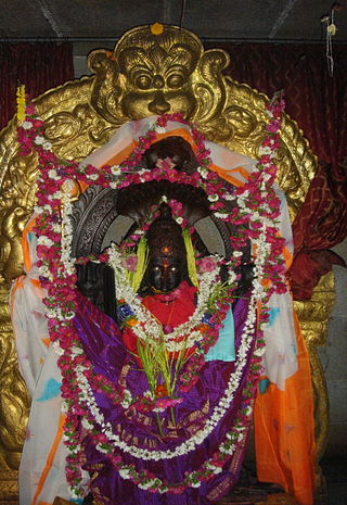
Hikkal is a hill in Urdigere Taluk, Tumkur District, and Karnataka State, India. It is approximately 16 km from the district's main city of Tumkur, and 70 km away from the capital city Bangalore. The hill houses a temple of Lord Srinivasa in the form of a stone resembling a ripped ant hill; Idols of goddesses Sridevi and Bhudevi are also present. The nearby village is named after the hill Hikkal and the deity Srinivasa is called Hikkallappa. There is also an idol of Balaji, which was installed in 1999. It was presented by the Tirumala Tirupathi Devasthanam (TTD) of Andhra Pradesh which recognised this temple as one of the 108 sub-shrines of the original deity at Tirumala.

