
South Korea is made up of 22 first-tier administrative divisions: 6 metropolitan cities, 1 special city, 1 special self-governing city, and 14 provinces, including three special self-governing provinces and five claimed by the ROK government. These are further subdivided into a variety of smaller entities, including cities, counties, districts, towns, townships, neighborhoods and villages.

Buk District is a gu, or district, in north central Ulsan, South Korea. Its name literally means "North Ward". It stretches roughly from the Ring Road to Mohwa into the north and out to the coast in the east.

Nam District is a gu, or district, in south-central Busan, South Korea. Much of Nam-gu sticks out into the Sea of Japan, forming a peninsula which separates Suyeong Bay from Busan Harbor. It has an area of 25.91 km2. Nam-gu officially became a gu of Busan in 1975. In 1995 part of Nam-gu was divided to form Suyeong-gu.

Dong District is a gu in central Busan, South Korea. It was one of the first 6 gu of Busan established in 1957.

Bupyeong District is one of the 10 administrative divisions that comprise Incheon, South Korea. Bupyeong District comprises an area of 12.35 square miles, and has a population of 508,587. It is located north of Namdong District, east of Seo District, and south of Gyeyang District. The city of Bucheon, in neighboring Gyeonggi Province, comprises its eastern limit.

Nam District (Nam-gu) is a district of Ulsan, South Korea. Its name literally means "South Ward".
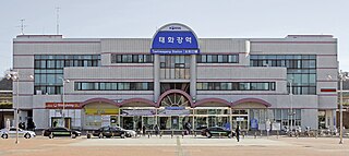
Taehwagang station, meaning Taehwa River station, is a train station located in Samsan-dong, Nam-gu, Ulsan. It was previously named Ulsan station until the KTX Ulsan station opened on November 1, 2010.

Ulsan Station (Tongdosa) is a South Korean high-speed rail station located in Samnam-eup, Ulju-gun. It is on Gyeongbu High Speed Railway and named Ulsan Station with subname Tongdosa, which is located in Yangsan, nearer than downtown Ulsan from the station. The existing Ulsan Station in Samsan-Dong, Nam-gu has been renamed to Taehwagang station.

Ulju County is a county occupying much of western Ulsan, South Korea.
Yaeum-dong was a dong, or neighborhood, of Nam-gu in Ulsan, South Korea. Yaeum-dong was originally subdivided into 3 smaller districts: Yaeum 1-Jangsaengpo-dong, Yaeum 2-dong, and Yaeum 3-dong. In 2007, Yaeum 1-Jangsaengpo-dong was renamed Yaeum-Jangsaengpo-dong, Yaeum 2-dong was renamed Daehyeon-dong, and Yaeum 3-dong was renamed Suam-dong.
Daehyeon-dong is a dong (neighborhood) of Nam District, Ulsan, South Korea.
Dal-dong is a dong, or neighborhood, of Nam District, Ulsan, South Korea.
Yaeum-Jangsaengpo-dong is a dong, or neighborhood, of Nam-gu in Ulsan, South Korea.
Suam-dong is a dong, or neighborhood, of Nam-gu in Ulsan, South Korea.
Mugeo-dong is a dong, or neighborhood, of Nam-gu in Ulsan, South Korea.
Ok-dong is a dong, or neighborhood, of Nam-gu in Ulsan, South Korea.
Seonam-dong is a dong, or neighborhood, of Nam-gu in Ulsan, South Korea.
Samho-dong is a dong, or neighborhood, of Nam-gu in Ulsan, South Korea.
Sinjeong-dong is a dong, or neighborhood, of Nam-gu in Ulsan, South Korea. Sinjung-dong is further divided into five subdivisions: Sinjeong-1-dong, Sinjeong-2-dong, Sinjeong-3-dong, Sinjeong-4-dong, and Sinjeong-5-dong.

Ulsan College is a private college with two campuses in Ulsan, South Korea. The East Campus is in Dong-gu and the West Campus in Nam-gu. It was founded on 8 April 1960 as the Ulsan Industrial Technology Institute. Hyundai Heavy Industries is the college's owner and financial sponsor.