San Antonio de Putina province

Last updated
San Antonio de Putina
La Rinconada Peru.jpg
Bandera Provincia Putina.png
Location of the province San Antonio de Putina in Puno.svg
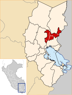
Location of San Antonio de Putina in the Puno Region
Country Peru
Region Puno
FoundedJune 12, 1989
Capital Putina
Government
  MayorAlex Max Sullca Cáceres
(2007-10)
Area
  Total
3,207.38 km2 (1,238.38 sq mi)
Elevation
3,874 m (12,710 ft)
Population
  Total
44,853
  Density14/km2 (36/sq mi)
UBIGEO 2110
Website www.muniputina.gob.pe

San Antonio de Putina province is a province of the Puno Region in Peru. [1]

Contents

Political division

The province measures 3,207.38 square kilometres (1,238.38 sq mi) and is divided into five districts:

DistrictMayorCapital Ubigeo
Ananea Crispin Amanqui Rodriguez Ananea 211002
Pedro Vilca Apaza Juan Pablo Salas Chipana Ayrampuni 211003
Putina Alex Max Sullca Caceres Putina 211001
Quilcapuncu Leonardo Lipa Alvarez Quilcapuncu 211004
Sina Marcial Huanca Mamani Sina 211005

Geography

The Apolobamba mountain range traverses the province. Wisk'achani (Chawpi Urqu), the highest mountain of the range, lies on the border with Bolivia. Other peaks of the province are listed below: [2]

Ethnic groups

The people in the province are mainly indigenous citizens of Quechua descent. Quechua is the language which the majority of the population (60.23%) learnt to speak in childhood, 30.24% of the residents started speaking using the Spanish language and 9.37% using Aymara (2007 Peru Census). [3]

See also

Related Research Articles

<span class="mw-page-title-main">Sandia province</span> Province in Puno, Peru

Sandia Province is a province of the Puno Region in Peru. The capital of the province is the city of Sandia.

<span class="mw-page-title-main">El Collao province</span> Province in Puno, Peru

El Collao Province is a province of the Puno Region in Peru, created in 1992. The capital of the province is the city of Ilave.

<span class="mw-page-title-main">Carabaya province</span> Province in Puno, Peru

Carabaya is a province of the Puno Region located in the southern part of Peru. It is bounded on the north by the Madre de Dios Region, on the east by the province of Sandia, on the south by the provinces of Azángaro, Melgar and Putina and on the west by the Cusco Region. The capital of the province is the city of Macusani.

San José District is one of fifteen districts of the Azángaro Province in Peru.

Ajoyani District is one of ten districts of the province Carabaya in Peru.

Crucero District is one of ten districts of the province Carabaya in Peru.

Ituata District is one of ten districts of the Carabaya Province in Peru.

Ullachiya District is one of ten districts of the province Carabaya in Peru.

Usicayos District is one of ten districts of the Carabaya Province in Peru.

Antauta District is one of nine districts of the province Melgar in Peru.

<span class="mw-page-title-main">Santa Rosa District, Melgar</span> District in Puno, Peru

Santa Rosa District is one of nine districts of the province Melgar in Peru.

Cuyocuyo District is one of ten districts of the province Sandia in Peru.

<span class="mw-page-title-main">Patambuco District</span> District in Puno, Peru

Patambuco District is one of ten districts of the Sandia Province in Peru.

Quiaca District is one of ten districts of the province Sandia in Peru.

<span class="mw-page-title-main">Ananea District</span> District in Puno, Peru

Ananea District is one of five districts of the San Antonio de Putina Province in Peru.

<span class="mw-page-title-main">Sina District</span> District in Puno, Peru

Sina District is one of five districts of the San Antonio de Putina Province in the Puno Region of Peru.

Putina District is one of five districts of the San Antonio de Putina Province in Peru.

Pedro Vilca Apaza District is one of five districts of the province San Antonio de Putina in Peru.

<span class="mw-page-title-main">Marangani District</span> District in Cusco, Peru

Marangani District is one of eight districts of the province Canchis in Peru.

San Pablo District is one of eight districts of the province Canchis in Peru.

References

  1. (in Spanish) Instituto Nacional de Estadística e Informática. Banco de Información Digital Archived 2008-04-23 at the Wayback Machine , Retrieved January 2, 2008
  2. escale.minedu.gob.pe/ UGEL map Putina Province (Puno Region)
  3. inei.gob.pe Archived 2013-01-27 at the Wayback Machine INEI, Peru, Censos Nacionales 2007

14°54′50″S69°52′25″W / 14.91389°S 69.87361°W / -14.91389; -69.87361