
The Angeles National Forest (ANF) of the U.S. Forest Service is located in the San Gabriel Mountains and Sierra Pelona Mountains, primarily within Los Angeles County in southern California. The ANF manages a majority of the San Gabriel Mountains National Monument.

The Desert Biosphere Reserve and Experimental Range is a biosphere reserve and experimental range in western Millard County, Utah, United States, that is listed as a historic district on the National Register of Historic Places.

The Golden Gate Biosphere Network is an internationally recognized voluntary coalition of federal, state, and local government agencies, nonprofit organizations, universities, and private partners within the Golden Gate Biosphere (GGB) region. The Network works towards protecting the biosphere region’s biodiversity and conserving its natural resources to maintain the quality of life for people within the region. The Network has been part of the UNESCO Man and Biosphere Programme since 1988 and is part of the US Biosphere Network and EuroMAB. It is recognized by UNESCO due to the significant biodiversity of the region, as well as the Network's efforts to demonstrate and promote a balanced relationship between humans and the biosphere.

The Coast Ranges of California span 400 miles (644 km) from Del Norte or Humboldt County, California, south to Santa Barbara County. The other three coastal California mountain ranges are the Transverse Ranges, Peninsular Ranges and the Klamath Mountains.

The Landels-Hill Big Creek Reserve is a constituent of the University of California Natural Reserve System. It is located off State Route 1 in the Big Sur area on California's central coast, fifty miles south of Monterey and adjacent to the Big Creek State Marine Reserve and Big Creek State Marine Conservation Area.

Redwood Creek Native Plant Nursery was located just outside the old-growth redwood forest at Muir Woods National Monument. The nursery provided plants for restoration of the creek bank in the lower watershed and impacted areas of the Muir Woods' redwood understory. It was moved to that location in 1992, and closed in 2015.
The San Joaquin Experimental Range is an ecosystem research experimental area in the foothills of the Sierra Nevada. The range is located in O'Neals, California, outside of the Sierra National Forest about 32 kilometres (20 mi) north of Fresno, California.
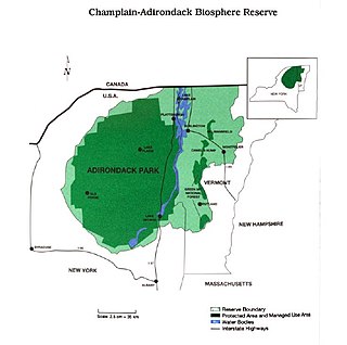
The Champlain-Adirondack Biosphere Network is a UNESCO-designated biosphere reserve. The Champlain-Adirondack Biosphere Network is part of a global network of 727 biosphere reserves in 131 countries and it is one of 28 internationally recognized biosphere regions in the United States.

The California Coast Ranges Biosphere Reserve was a UNESCO Biosphere reserve located along the California Coast Ranges of northern California and the San Francisco Bay area until June 2017. This biosphere reserve includes a highly diverse complex of evergreen sclerophyllous woodland, coastal, estuary and marine ecosystems.
Niwot Ridge is an alpine ecology research station located 65 km north-west of Denver in north-central Colorado. It is on the Front Range of the southern Rocky Mountains and lies within the Roosevelt National Forest. Niwot Ridge is 2,900 metres (9,500 ft) high.
The San Joaquin Biosphere Reserve is a UNESCO Biosphere Reserve located on the western slopes of the central Sierra Nevada mountains Madera County, California, about 20 miles (32 km) north of Fresno. This biosphere reserve represents the California steppe and California woodlands with blue oak, interior live oak. and digger pine.

The Central Plains Biosphere Reserve was a UNESCO Biosphere Reserve located in the western central Great Plains in north-central Colorado in the shortgrass prairie. The 6,210 hectares (24.0 sq mi) reserve encompasses the Central Plains Experimental Range (CPER) administered by the United States Department of Agriculture's Agricultural Research Service.

The Fraser Experimental Forest is an outdoor research laboratory to study timber, water, wildlife management, and their integration in the high elevation subalpine coniferous forests. The experimental forest was established in 1937, and encompasses 9,328 hectares (36.02 sq mi). It is situated on the west side of the Continental Divide in north-central Colorado and includes the entire watershed of Main St. Louis Creek, a tributary of the Fraser River.

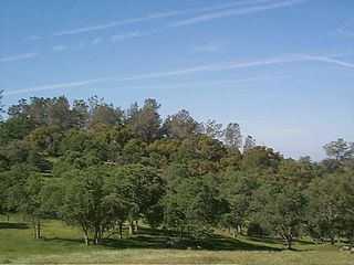
Big Dalton Dam is a multiple arch concrete dam in Los Angeles County, California, built for the Los Angeles County Flood Control District and completed in August 1929. The dam is one of the earliest of the multiple arch "double-wall" buttress designs of engineer Fred A. Noetzli. The 991 acre-foot dam provides water conservation and controls flooding from Big Dalton Canyon, a watershed within the San Dimas Experimental Forest, part of the Angeles National Forest in the San Gabriel Mountains. It is about 4 miles northeast of the city of Glendora and is operated by the Los Angeles County Department of Public Works.

The Jornada Biosphere Reserve is a UNESCO Biosphere Reserve in southern New Mexico. It is one of three biosphere reserves representing the Chihuahuan Desert. The area extends from the crest of the San Andres Mountains, which are dominated by shrub woodlands, to the Jornada Plains characterized by semi-desert grasslands.
The Stanislaus-Tuolumne Experimental Forest is an experimental forest under the management of the United States Forest Service. It was a UNESCO Biosphere Reserve established 1976 and withdrawn in 2017. Stanislaus-Tuolumne is located on the western slopes of the central Sierra Nevada mountains near Pinecrest, California about 15 kilometres (9.3 mi) northwest of Yosemite National Park.
The Middle Zambezi Biosphere Reserve is a UNESCO Biosphere Reserve located along the Zambezi River in the Zambezi Valley of Zimbabwe. The 2,879,300 hectares (11,117 sq mi) reserve consists of riverine and terrestrial ecosystems unique to the subcontinent. Among threatened species found in the valley are the black rhino, the painted wild dog, and the nyala. The flora consist of Colophospermum/Combretum/Terminalia woodland and the Zambezi riparian forest. At Mana Pools, it comprises the only flood plain ecosystem left in the Middle Zambezi.

The Ciénaga de Zapata Biosphere Reserve is a UNESCO Biosphere Reserve situated on the southern coast of Cuba at Matanzas province. The 628,171 hectares (2,425.38 sq mi) reserve encompasses the Zapata Swamp and is one of the largest and most important wetlands in the Caribbean region with a marine southern borderline. Ciénaga de Zapata was designated a Ramsar site in 2001. This area is a cluster biosphere reserve with several core areas, highly valuable for conservation located in the Ciénaga de Zapata National Park.

La Encrucijada Biosphere Reserve is a UNESCO Biosphere Reserve situated in the Pacific Coastal Lowlands physiographic region of Mexico. It covers 144,848 hectares (559.26 sq mi) stretching over six municipalities in the Costa de Chiapas. It is composed of two large coastal lagoon systems that correspond to two core areas, and a wide variety of natural ecosystems including mangroves, zapotonales, tule swamps and marshes, as well as patches of tropical seasonal forest, coastal dunes and palm trees.

Barranca de Metztitlán is a biosphere reserve in Hidalgo state of Mexico. It is protected for its dramatic scenery of steep cliffs and deep winding canyons, and its distinctive flora and fauna.


