
Ratcliff is a city in Logan County, Arkansas, United States. The population was 191 at the 2000 census.
Newington Park was a baseball grounds in Baltimore, Maryland. It was home to the Lord Baltimore baseball club of the National Association from 1872 to 1874 and to the Baltimore Orioles of the American Association for the 1882 season. There are apparently no surviving photographs of the grounds. Its location was on Pennsylvania Avenue "extended," on the northwest side of West Baltimore.

Água Boa is a city in the Brazilian state of Minas Gerais. In 2004 its population was estimated to be 18,834.
Charlie Lake Provincial Park is a provincial park in British Columbia, Canada, established on the western shore of Charlie Lake. It is roughly 92 hectares in size.

Minnesota's 3rd congressional district encompasses the suburbs of Hennepin County to the north, west, and south of Minneapolis. With blue collar Brooklyn Park and Coon Rapids to the north-east, middle-income Bloomington to the south, and higher-income Eden Prairie, Edina, Maple Grove, Plymouth, Minnetonka, and Wayzata to the West with Champlin, it features a mixed characteristic. Democrat Dean Phillips currently represents the district in the U.S. House of Representatives, after defeating Erik Paulsen in the November 2018 midterm elections.
Aczo District is one of six districts of the province Antonio Raymondi in Peru.

Butler Center is an unincorporated community in Butler Township, DeKalb County, Indiana.
Anra District is one of sixteen districts of the province Huari in Peru.
Huacchis District is one of sixteen districts of the province Huari in Peru.
Paucas District is one of sixteen districts of the province Huari in Peru.
Ponto District is one of sixteen districts of the province Huari in Peru.
Uco District is one of sixteen districts of the province Huari in Peru.

Zelgoszcz is a village in the administrative district of Gmina Wartkowice, within Poddębice County, Łódź Voivodeship, in central Poland. It lies approximately 9 kilometres (6 mi) west of Wartkowice, 12 km (7 mi) north-west of Poddębice, and 47 km (29 mi) north-west of the regional capital Łódź.
Morgan Run Natural Environment Area is a protected area in Carroll County, Maryland. Located on 1,930 acres (7.8 km2), Morgan Run features hiking and equestrian trails, catch and release trout fishing, and deer hunting.
Pustki is a village in the administrative district of Gmina Czersk, within Chojnice County, Pomeranian Voivodeship, in northern Poland. It lies approximately 9 kilometres (6 mi) north of Czersk, 35 km (22 mi) north-east of Chojnice, and 69 km (43 mi) south-west of the regional capital Gdańsk.
Mulungu, Ceará is a municipality in the state of Ceará in the Northeast region of Brazil.

Pashuk Glacier is the steep 2.7 km long and 600 m wide glacier on the southeast side of Imeon Range, Smith Island in the South Shetland Islands, Antarctica, which is draining southeastwards from Vakarel Saddle between the side ridges descending from Antim Peak and Evlogi Peak and separating it from Krivodol Glacier to the north and Rupite Glacier to the south respectively, and flows into Osmar Strait southwest of Sredets Point.

Kolosh Glacier is the 6.7 km long and 3.6 km wide glacier on Magnier Peninsula, Graham Coast on the west side of Antarctic Peninsula, situated south of Nesla Glacier. It drains the west slopes of Lisiya Ridge north of Mount Bigo, and flows northwestwards into Bigo Bay next south of the terminus of Nesla Glacier.
Santa Ana is a municipality in the province of Cáceres and autonomous community of Extremadura, Spain. The municipality covers an area of 34.99 square kilometres (13.51 sq mi) and as of 2011 had a population of 294 people.
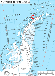
Shterna Glacier is the glacier extending 3.6 km in east-west direction and 2.2 km in north-south direction on Liège Island in the Palmer Archipelago, Antarctica. It is situated northeast of Sigmen Glacier, draining the north slopes of Brugmann Mountains and flowing northwards into Boisguehenneuc Bay.


