
Auberry is a census-designated place (CDP) in Fresno County, California, United States. The population was 2,369 at the 2010 census, up from 2,053 at the 2000 census. Auberry is located on Little Sandy Creek 9.5 miles (15 km) west of Shaver Lake Heights, at an elevation of 2,018 feet (615 m).

Clovis is a city in Fresno County, California, United States. Clovis was established in 1890 as a freight stop for the San Joaquin Valley Railroad by a group of Fresno businessmen and Michigan railroad speculator Marcus Pollasky. The railroad bought the land from two farmers and named the station after one of them, Clovis Cole. Pollasky then developed a town on the site, also named Clovis.

The San Joaquin River is the longest river of Central California. The 366-mile (589 km) long river starts in the high Sierra Nevada, and flows through the rich agricultural region of the northern San Joaquin Valley before reaching Suisun Bay, San Francisco Bay, and the Pacific Ocean. An important source of irrigation water as well as a wildlife corridor, the San Joaquin is among the most heavily dammed and diverted of California's rivers.

Sierra National Forest is a U.S. national forest located on the western slope of central Sierra Nevada in Central California and bounded on the northwest by Yosemite National Park and the south by Kings Canyon National Park. The forest is known for its mountain scenery and beautiful lakes. Forest headquarters are located in Clovis, California. There are local ranger district offices in North Fork and Prather.
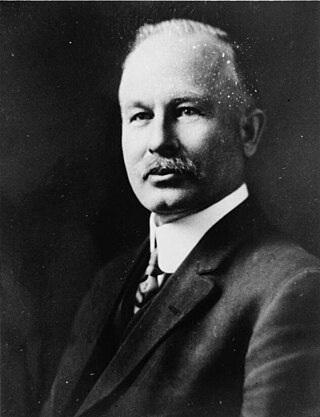
John Samuel Eastwood was an American engineer who built the world's first reinforced concrete multiple-arch dam on bedrock foundation at Hume Lake, California, in 1908, and was one of California's pioneers of hydroelectric power production. Eastwood's papers are held at the Water Resources Collections and Archives, University of California, Riverside.
Big Creek is a small census-designated place in Fresno County, California, located in the Sierra Nevada on the north bank of Big Creek. It lies at an elevation of 4,984 feet (1,519 m) above sea level. Its last population count was 175. The ZIP code is 93605, and the community is inside area code 559.

Friant Dam is a concrete gravity dam on the San Joaquin River in central California in the United States, on the boundary of Fresno and Madera Counties. It was built between 1937 and 1942 as part of a U.S. Bureau of Reclamation (USBR) water project to provide irrigation water to the southern San Joaquin Valley. The dam impounds Millerton Lake, a 4,900-acre (2,000 ha) reservoir about 15 miles (24 km) north of Fresno.

Shaver Lake is an artificial lake on Stevenson Creek, in the Sierra National Forest of Fresno County, California. At elevation 5,500 ft (1,700 m), several smaller streams also flow into the lake, and it receives water from the tunnels of Southern California Edison's Big Creek Hydroelectric Project. The town Shaver Lake is located on its south-west shore.

Big Creek is a 19.3-mile-long (31.1 km) tributary of the San Joaquin River in the Sierra Nevada, within the Sierra National Forest, central California.
Huntington Lake is a reservoir in Fresno County, California on Big Creek, located in the Sierra Nevada at an elevation of 6,955 feet (2,120 m). The lake receives water from Southern California Edison's Big Creek Hydroelectric Project, as well as the many streams that flow into the lake. Some water leaving the lake flows to Big Creek, while some is diverted to nearby Shaver Lake. The lake is home to a variety of recreational activities, including camping, horse-back riding, skiing, sailing, fishing and more. It is drained and refilled through the Big Creek dam system each year, with winter water levels often dipping below 50 percent of the lake's capacity.

Millerton Lake is an artificial lake near the town of Friant about 15 mi (24 km) north of downtown Fresno. The reservoir was created by the construction of 319 ft high Friant Dam on the San Joaquin River which, with the lake, serves as much of the county line between Fresno County to the south and Madera County to the north.
The Shaver Lake Railroad was a standard gauge logging railroad that operated in the Sierra Nevada of Fresno County, California. The line was abandoned in 1927.
El Prado is a former settlement in Fresno County, California. It was located at the junction of the San Joaquin and Eastern and the Southern Pacific Railroads 6 miles (9.7 km) north-northwest of Clovis, at an elevation of 377 feet. The primary function of the settlement was as a switch yard and was initially known as "Nopac Siding", which was changed to El Prado shortly after its construction. It still appeared on maps as of 1922.
Lerona is an unincorporated community in Fresno County, California. It is located 6.5 miles (10 km) west-northwest of Shaver Lake Heights, at an elevation of 2789 feet.

Temperance Flat Dam is a proposed dam project on the San Joaquin River west of Auberry, California. Construction of the dam is currently on hold. The dam's main purpose would be to supplement storage capacity in the upper San Joaquin River basin. Under the current proposal, Temperance Flat would slightly more than double water storage on the San Joaquin River from below Friant Dam. The project is highly controversial because it would flood scenic canyons and historic sites along the San Joaquin River, and impact upstream hydroelectricity generation. The Bureau of Reclamation estimates the construction costs will be between US$2.5 billion and $2.6 billion, while other estimates range from $2.96 billion up to $3.35 billion. At 665 feet, Temperance Flat Dam would be the second highest dam in California, and the fifth tallest dam in the United States.

The Big Creek Hydroelectric Project is an extensive hydroelectric power scheme on the upper San Joaquin River system, in the Sierra Nevada of central California. The project is owned and operated by Southern California Edison (SCE). The use and reuse of the waters of the San Joaquin River, its South Fork, and the namesake of the project, Big Creek – over a vertical drop of 6,200 ft (1,900 m) – have over the years inspired a nickname, "The Hardest Working Water in the World".

Lake Thomas A Edison is a reservoir in the Sierra National Forest and in Fresno County, California. It is in the Sierra Nevada, and near the Pacific Crest Trail.

The South Fork San Joaquin River is the largest headwater of the San Joaquin River in central California, United States. About 48 miles (77 km) long, it drains an area of the high Sierra Nevada about 60 miles (97 km) northeast of Fresno.

The Creek Fire was a large wildfire which started on September 4, 2020, near Shaver Lake, California, and became one of the largest fires of the 2020 California wildfire season. The fire burned 379,895 acres (153,738 ha) and was declared 100% contained on December 24, 2020. The fire burned mostly in the Sierra National Forest. The Creek Fire was the fifth-largest wildfire in modern California history, and the second-largest single fire not part of a greater complex. The fire necessitated the rescue of hundreds of people by National Guard helicopters. Evacuations were issued in North Fork, Bass Lake, Big Creek, Shaver, Huntington Lake, Tollhouse and Auberry, California. Half the homes in Big Creek were reported to have been destroyed by the fire. The Creek Fire destroyed at least 856 buildings and cost over $193 million in fire suppression costs, while the total property damage is currently unknown.
The Fresno Flume and Irrigation Company was established in 1891 as a logging and water transportation company in California. A 45-mile cedar flume was built to transport lumber from Shaver Lake to the finishing mill in Clovis. The company changed its name to the Fresno Flume and Lumber Company in 1908, and over the course of its 21-year lifespan, cut an average of 25 million board feet of lumber each year. However, in 1912, the company was sold and ceased all operations after a storm destroyed 2 miles (3.2 km) of the flume. In 1919, Southern California Edison Company bought most of the Shaver property for the Big Creek Hydroelectric Project.


