The San Francisco Peninsula is a peninsula in the San Francisco Bay Area that separates San Francisco Bay from the Pacific Ocean. On its northern tip is the City and County of San Francisco. Its southern base is Mountain View, south of Palo Alto and north of Sunnyvale and Los Altos. Most of the Peninsula is occupied by San Mateo County, between San Francisco and Santa Clara counties, and including the cities and towns of Atherton, Belmont, Brisbane, Burlingame, Colma, Daly City, East Palo Alto, El Granada, Foster City, Hillsborough, Half Moon Bay, La Honda, Loma Mar, Los Altos, Menlo Park, Millbrae, Pacifica, Palo Alto, Pescadero, Portola Valley, Redwood City, San Bruno, San Carlos, San Mateo, South San Francisco, and Woodside.

Harlem Heights is an unincorporated community and census-designated place (CDP) in Lee County, Florida, United States. The population was 1,930 at the 2020 census, down from 1,975 at the 2010 census. It is part of the Cape Coral-Fort Myers, Florida Metropolitan Statistical Area.
Wisner Township is a civil township of Tuscola County in the U.S. state of Michigan. The population was 690 at the 2010 Census.

The Greenbelt is a 203.5-square-kilometre (78.6 sq mi) protected green belt traversing Ottawa, Ontario, Canada. It includes green space, forests, farms, and wetlands from Shirleys Bay in the west and to Green's Creek in the east. It is the largest publicly owned green belt in the world and the most ecologically diverse area in Eastern Ontario. The National Capital Commission (NCC) owns and manages 149.5 square kilometres (57.7 sq mi), and the rest is held by other federal government departments and private interests. Real estate development within the Greenbelt is strictly controlled.
Pearse Island is an island in western British Columbia, Canada, in the Portland Inlet, an inlet of the Pacific Ocean. The island was first charted in 1793 by George Vancouver during his 1791-95 expedition. It was named by George Henry Richards, captain of HMS Plumper, circa 1860, in honour of William Alfred Rombulow Pearse of the Royal Navy, who had been commander of HMS Alert.

Raft Cove Provincial Park is a provincial park in British Columbia, Canada, located south of San Josef Bay on northwestern Vancouver Island.

The Stswecem'c Xgat'tem First Nation, formerly known as Canoe Creek Band/Dog Creek Indian Band, created as a result of merger of the Canoe Creek Band and Dog Creek Band is a First Nations government of the Secwepemc (Shuswap) Nation, located in the Fraser Canyon-Cariboo region of the Central Interior of the Canadian province of British Columbia. It was created when the government of the then-Colony of British Columbia established an Indian reserve system in the 1860s. It is a member government of the Northern Shuswap Tribal Council.
The Lytton First Nation, a First Nations band government, has its headquarters at Lytton in the Fraser Canyon region of the Canadian province of British Columbia. While it is the largest of all Nlaka'pamux bands, unlike all other governments of the Nlaka'pamux (Thompson) people, it is not a member of any of the three Nlaka'pamux tribal councils, which are the Nicola Tribal Association, the Fraser Canyon Indian Administration and the Nlaka'pamux Nation Tribal Council.

Mendota Township is located in LaSalle County, Illinois, United States. As of the 2010 census, its population was 7,534 and it contained 3,111 housing units. Mendota Township was formed from Meriden Township in February, 1856.
Rocky Point is a peninsula in Plymouth, Massachusetts. The peninsula runs along Warren Cove and Plymouth Bay. The tip of the peninsula marks the convergence of Plymouth Bay and the larger Cape Cod Bay. The land rising from Plymouth Bay is considered to be the foothills to the Pine Hills.
Wentworth is an unincorporated community, in the town of Amnicon, Douglas County, Wisconsin, United States.
Yale First Nation is a First Nations government located at Yale, British Columbia. Yale has 16 distinct reserves stretching from near Sawmill Creek to American Creek, with the most southern reserve situated at Ruby Creek in the District of Kent.

Feudal is a hamlet in Perdue No. 346, Saskatchewan, Canada. The hamlet is located at the junction of Highway 655 and Township road 340 approximately 15 km north of the Village of Harris.
Aloha is an unincorporated community in Grant Parish, Louisiana, United States.
Division No. 1, Subdivision L is an unorganized subdivision on the Avalon Peninsula in Newfoundland and Labrador, Canada. It is in Division 1 and contains the unincorporated communities of Bareneed, Black Duck Pond, Blow Me Down, Coley's Point South, Hibb's Cove, Pick Eyes, Port de Grave, Ship Cove and The Dock
Westland is an unincorporated community in Warren Township, Putnam County, in the U.S. state of Indiana.
Havenhurst is an unincorporated community in southern McDonald County, in the U.S. state of Missouri. The community is located on Missouri Route K, just north of U.S. Route 71, approximately one mile southeast of Pineville. The site is on the bank of Little Sugar Creek.
Griswold Creek is a stream in San Benito County, California. Its head is at the confluence of Pimental Creek and Vallecitos Creek. From there it flows north-northeastward through the canyon between the Griswold Hills in the east, and Buck Peak in the Diablo Range on the west, to its mouth, located at an elevation of 1,145 feet (349 m) at its confluence with Panoche Creek 1.5 miles (2.4 km) southeast of Panoche in the Panoche Valley.
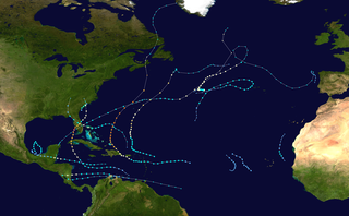
The 2022 Atlantic hurricane season saw an average number of named storms and hurricanes, and below average number major hurricanes. There were fourteen named storms during the season; eight of them strengthened into a hurricane, and two of those reached major hurricane intensity. The season officially began on June 1, and ended on November 30. These dates, adopted by convention, historically describe the period in each year when most subtropical or tropical cyclogenesis occurs in the Atlantic Ocean. No subtropical or tropical development occurred in the Atlantic prior to the start of the season, making this the first since 2014 not to have a pre-season named storm. The season's first storm, Tropical Storm Alex, formed on June 5, and the last, Hurricane Nicole, dissipated on November 11.