
The Sierra Madre de Oaxaca is a mountain range in southern Mexico. It is primarily in the state of Oaxaca, and extends north into the states of Puebla and Veracruz.
Cuajinicuilapa is a municipality in the Mexican state of Guerrero. The municipal seat lies at Cuajinicuilapa. The municipality covers an area of 857.1 km². In 2020, the municipality had a total population of 26,627, up from 25,537 in 2005.
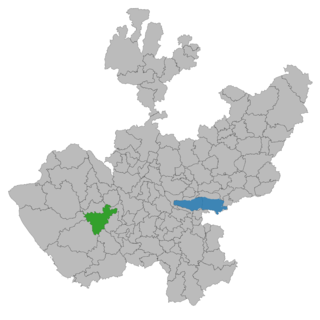
Ayutla is a town and municipality, in Jalisco in central-western Mexico. The municipality covers an area of 883.4 km².

Abejones is a town and municipality in Oaxaca in south-western Mexico. The municipality covers an area of 122.48 km2. It is part of the Ixtlán District in the Sierra Norte de Oaxaca region. It shares borders with San Pablo Macuiltianguis to the north, with Santa Ana Yareni and Santa María Jaltianguis to the south, with San Juan Bautista Atatlahuca, San Miguel Aloapam and San Juan Bautista Jayacatlán to the west, and with San Pablo Macuiltianguis, San Juan Atepec and San Juan Evangelista Analco to the east. Its approximately 94 km from the city of Oaxaca. This area has a very uneven terrain and there is no hectare that is a complete level in the whole municipality. The local mountains are called the Sierra Marcos Pérez and some of its mountains reach the three thousand meters. It is quite a dry region but the cold weather helps some fruit trees and forests. The only river near is the Rio Grande. As of 2005, the municipality had a total population of 1,114.
San Juan Mazatlán is a town and municipality in Oaxaca in south-western Mexico. It is part of the Sierra Mixe district within the Sierra Norte de Oaxaca Region. Mazatlán's name in Nahuatl means "the place of deer".
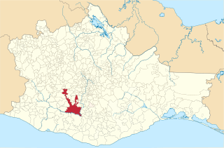
Villa Sola de Vega is a town and municipality in Oaxaca in south-western Mexico, part of the Sola de Vega District in the Sierra Sur Region. The meaning "Place of quails" comes from "zollin": quail and "tlán": place of
San Pablo Coatlán is a town and municipality in Oaxaca in south-western Mexico. The municipality covers an area of 195.2 km². It is part of the Miahuatlán District in the south of the Sierra Sur Region.

San Pablo Macuiltianguis is a town and municipality in Oaxaca in south-western Mexico. It is part of the Ixtlán District in the Sierra Norte region.
San Pablo Yaganiza is a town and municipality in Oaxaca in south-western Mexico. The municipality covers an area of km². It is part of the Villa Alta District in the center of the Sierra Norte Region.
San Pedro Cajonos is a town and municipality in Oaxaca in south-western Mexico. The municipality covers an area of km². It is part of the Villa Alta District in the center of the Sierra Norte Region. It was founded on September 16, 1700 and given the name of San Pedro Cajonos. The language spoken in the town is a mix of Spanish and a lesser amount of spoken indigenous language called Cajonos Zapotec.
Huamelula is a town and municipality in Oaxaca in south-western Mexico. It is in the west of the Tehuantepec District in the west of the Istmo Region, on the Pacific coast.
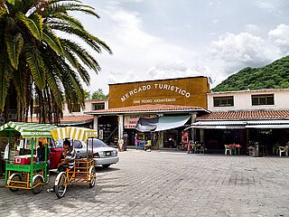
San Pedro Juchatengo is a town and municipality in Oaxaca in south-western Mexico. It is part of the Juquila District in the centre of the Costa Region. The name comes from "Xochiatengo", which means "Flowers on the waters edge".
San Pedro Mixtepec is a town and municipality in the Miahuatlán District of Oaxaca in south-western Mexico. The municipality covers an area of km². It is part of the Miahuatlán District in the south of the Sierra Sur Region.
San Pedro Ocotepec is a town and municipality in Oaxaca in south-western Mexico. The municipality covers an area of 136.51 km². It is part of the Sierra Mixe district within the Sierra Norte de Oaxaca Region.
San Pedro Yaneri is a town and municipality in Oaxaca in south-western Mexico. The municipality covers an area of 79.1 km².
San Pedro y San Pablo Tequixtepec is a town and municipality in Oaxaca in south-western Mexico. The municipality covers an area of km². Having the longest place name in Mexico, it is part of the Huajuapan District in the north of the Mixteca Region.
San Pedro y San Pablo Teposcolula is a town and municipality in Oaxaca in south-western Mexico. The municipality covers an area of km2. It is part of the Teposcolula District in the center of the Mixteca Region

Ixtlán District is located in the Sierra Norte region, in the northeastern area of the State of Oaxaca, Mexico.
San Pedro y San Pablo is Spanish for Saint Paul and Saint Peter. It may refer to:


