
Tumon is a district located on Tumon Bay along the northwest coast of the United States unincorporated territory of Guam. Located in the municipality of Tamuning, it is the center of Guam's tourist industry.
Matå'pang was a Chamorro maga'låhi or chief of the ancient Chamorro village of Tomhom on the island of Guahan. His name meant "to be made pure by cleansing" in Chamorro.

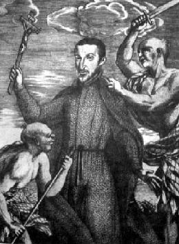
Diego Luis de San Vitores, SJ was a Spanish Jesuit missionary who founded the first Catholic church on the island of Guam. He is responsible for establishing the Christian presence in the Mariana Islands. He is a controversial figure in some circles due to his role in the Spanish–Chamorro Wars.
Tumon Bay is a bay in the United States territory of Guam, opening to the Philippine Sea. It is bounded to the north by Two Lovers Point and to the south by Ypao Point. The entirety of the bay falls within the Tumon Bay Marine Preserve, also known as the Tumon Bay Marine Preserve Area (MPA) and Tumon Preserve, one of five marine preserves on Guam. The Preserve measures 4.54 square kilometers and is roughly two miles long. The platform of the fringing reef that separates the open ocean from the lagoon is up to 1,450 feet (440 m) wide. and up to one mile from the shore. The bay is located off of the Tumon area, the tourist center of the island, in the village of Tamuning. The bay is extensively utilized for recreation and fishing.
Guam Highway 14 (GH-14) is one of the primary automobile highways in the United States territory of Guam.
10th Independent Mixed Regiment was a regiment of the Imperial Japanese Army that has association with a number of U.S. National Register of Historic Places-listed places in Guam.
The Ilik River Fortification II near Yona, Guam was built by Japanese forces during World War II. It was listed on the U.S. National Register of Historic Places in 1991.

The As Sombreru Pillbox I, As Sombreru Pillbox II, and As Sombreru Pillbox III are three historic defensive fortifications on Guam, near Tumon, that were listed on the U.S. National Register of Historic Places in 1991. They are pillboxes, a type of defensive fortification, built by the 48th Independent Mixed Brigade; 29th Division of the Imperial Japanese Army during 1941-1944, between Japan capturing Guam on December 8, 1941 from the United States and the U.S. recapturing Guam in 1944.

The San Vitores Martyrdom Site, located 0.7 miles south of Bijia Point off Guam Highway 4 in Tamuning, Guam, has significance from 1672. It was listed on the National Register of Historic Places in 1975.

The Agat Invasion Beach is a historic site in the village of Agat, Guam. The beaches of Agat were one of the landing sites of American forces in the 1944 Battle of Guam, in which the island was retaken from occupying Japanese forces. The designated historic site includes the beaches and inland areas extending between Bangi Point and Togcha Beach. Surviving remnants of the Japanese defenses on this stretch of coast include trenches and rifle pits located a short way inland, and a fortified bunker and 40mm gun emplacements at Ga'an Point. Remnants of pillboxes that had lined the beach also survive, with one at Gangi Point in relatively good condition.

The Agat World War II Amtrac is an underwater relic of World War II, located off Ga'an Point in Agat Bay on the west side of the island of Guam. It is the remains of an LVT 4, an amphibious tracked landing vehicle. It is located about 500 yards (460 m) off Agat Invasion Beach in 45 feet (14 m) of water, and was described as being in good condition when it was discovered and surveyed in 1985. These vehicles were used during the 1944 Battle of Guam, in which American forces recaptured the island from occupying Japanese forces. This particular vehicle does not appear to exhibit significant war damage. This is the most intact of the three Amtracks remaining on Guam from the 850 that participated in the battle. It was re-surveyed by maritime archaeological field schools conducted from 2009 to 2012.

The Asan Invasion Beach is a historic site in the village of Asan, Guam. The beaches of Asan were one of the landing sites of American forces in the 1944 Battle of Guam, in which the island was retaken from occupying Japanese forces. The designated historic site includes the beaches extending between Asan Point and Adelup Point, and extends inland roughly to Guam Highway 1. It also includes the water area extending from the beach to the reef, about 100 metres (330 ft) out, an area that includes at least one abandoned Allied landing vehicle.

The Dungcas Beach Defense Guns are an old World War II Japanese fortification in the United States territory of Guam. It consists of a tunnel dug in the coral limestone of the cliffs overlooking the beach on the northeast east side of Hagåtña Bay on the west side of the island. The tunnel has two guns mounted at openings facing the beach. This fortification was built by the 48th Independent Mixed Brigade of the 29th Division of the Imperial Japanese Army, during its occupation of the island 1941–44. The guns from this position were probably fired on landing Allied forces during the 1944 Battle of Guam, in which the United States retook the island.

The Asan Ridge Battle Area was the scene of some of the heaviest fighting in the 1944 Battle of Guam, the World War II battle in which Allied forces recaptured Guam from occupying Japanese forces. The area is now part of the Asan Inland Unit of the War in the Pacific National Historical Park, and was listed on the National Register of Historic Places in 1975. The area is just inland of the Asan Invasion Beach, one of the two major beachheads established by the Allies, and has a commanding view over that area. The landforms included in this area are Chorrito Cliff, Bundschuh Ridge, and Nimitz Hill, and they were heavily fortified by the Japanese prior to the battle. Surviving elements of these fortifications include two concrete pillboxes, and an unfinished battery of 4-inch guns.
Fort San Jose is a former Spanish fortification on the island of Guam, now a United States territory. It is located north of the village of Umatac, on a hill overlooking both Fouha Bay and Umatac Bay, the place were Spanish galleons traveling between Manila in the Spanish Philippines and Acapulco, Mexico stopped for water and supplies.
The Ipao Pillbox I is one of three surviving World War II-era fortifications on Ypao Point, located west of Tumon Bay on the west side of the island of Guam. It is built into the limestone cliff overlooking the beach on the property of the Hilton Hotel, about 17 metres (56 ft) in from the high tide line. Its walls are fashioned out of coral rock and cement, varying in thickness from 1 metre (3.3 ft) to 1.6 metres (5.2 ft). Its entrance is on the east wall, and its gun port faces north, overlooking Ypao Channel. Parts of the structure have been restored.
The Talofofo Pillbox is a historic World War II-era defensive fortification in Talofofo, Guam. It is located near the coast, about 127 metres (417 ft) south of the mouth of the Togcha River and 27 metres (89 ft) inland from the high-tide line. It is roughly 2.75 by 3.0 metres, built out of concrete and coral limestone. Its walls are about 0.5 metres (1.6 ft) thick, with an embrasure providing a view of the Togcha River, and a window looking over the coast to the east. Its entrance is on the landward (south) side. This structure was built under the direction of the Imperial Japanese Army during its occupation of Guam in 1941–44.
The Tokcha' Pillbox is a Japanese-built World War II-era defensive fortification on the island of Guam. It is built on a limestone terrace on Togcha Point, about 1 mile (1.6 km) north of the Togcha River and 0.7 miles (1.1 km) south of the Ylig River. It is set in a depression excavated from the limestone about 15 metres (49 ft) inland from the high tide land and 1 metre (3.3 ft) above sea level. It is a roughly rectangular structure built out of steel-reinforced concrete filled with coral and beach aggregate. The entrance is on the north wall, sheltered by a wall of coral blocks, and the gun port is on the south wall. This structure was built under the direction of the Japanese military during their occupation of the island 1941–44.

The Tumon Bay Japanese fortifications are a collection of World War II-era military structures along the coast of Guam in and near the village of Tumon. Many of these structures were listed on the National Register of Historic Places in 1991, using the alternate spelling "Tomhum". They include pillboxes on or close to the beach, and concrete structures and caves located a short way inland on the limestone cliffs that overlook the beach.
San Vitores may refer to:


