The War in the Pacific National Historical Park is a multi-unit protected area in the United States territory of Guam, which was established in 1978 in honor of those who participated in the Pacific Theater of World War II. Uniquely among the National Park System, it honors the bravery and sacrifices of all those who participated in the Pacific Theater.

British hardened field defences of World War II were small fortified structures constructed as a part of British anti-invasion preparations. They were popularly known as pillboxes, a reference to their shape.

Landing Beaches; Aslito/Isely Field & Marpi Point, Saipan Island is a National Historic Landmark District consisting of several discontiguous areas of the island of Saipan in the Northern Mariana Islands. The sites were designated for their association with the Japanese defense of Saipan during World War II, the 1944 Battle of Saipan in which United States forces captured the island, and the subsequent campaigns which used Saipan as a base. The district includes the landing beaches where the U.S. forces landed, the remnants of Japanese airfields Aslito and Marpi Point and Isely Field, the airfield built over much of Aslito from which B-29 bombers were used to bomb the Japanese home islands. Included in the Marpi Point area are Suicide Cliff and Banzai Cliff, two locations where significant numbers of Japanese military and civilians jumped to their deaths rather than surrender to advancing U.S. forces. The loss of Saipan was a major blow to the Japanese war effort, leading to the resignation of Prime Minister Hideki Tojo, The landmark designation was made in 1985.
10th Independent Mixed Regiment was a regiment of the Imperial Japanese Army that has association with a number of U.S. National Register of Historic Places-listed places in Guam.
The Ilik River Fortification II near Yona, Guam was built by Japanese forces during World War II. It was listed on the U.S. National Register of Historic Places in 1991.

The As Sombreru Pillbox I, As Sombreru Pillbox II, and As Sombreru Pillbox III are three historic defensive fortifications on Guam, near Tumon, that were listed on the U.S. National Register of Historic Places in 1991. They are pillboxes, a type of defensive fortification, built by the 48th Independent Mixed Brigade; 29th Division of the Imperial Japanese Army during 1941-1944, between Japan capturing Guam on December 8, 1941 from the United States and the U.S. recapturing Guam in 1944.

The Agat Invasion Beach is a historic site in the village of Agat, Guam. The beaches of Agat were one of the landing sites of American forces in the 1944 Battle of Guam, in which the island was retaken from occupying Japanese forces. The designated historic site includes the beaches and inland areas extending between Bangi Point and Togcha Beach. Surviving remnants of the Japanese defenses on this stretch of coast include trenches and rifle pits located a short way inland, and a fortified bunker and 40mm gun emplacements at Ga'an Point. Remnants of pillboxes that had lined the beach also survive, with one at Gangi Point in relatively good condition.

The Agana-Hagåtña Pillbox is a former Japanese defensive fortification in Hagåtña, Guam. It is a six-sided reinforced concrete structure, located a short way above the high-tide line on the west side of the Paseo de Susana, a small peninsula jutting north from the village center. There is another wall providing cover for the entrance on the land side. The interior is divided into two chambers, each of which has a gun port. The structure was built by Guam's Japanese defenders during their occupation of the island (1941–44) in World War II.

The Dungcas Beach Defense Guns are an old World War II Japanese fortification in the United States territory of Guam. It consists of a tunnel dug in the coral limestone of the cliffs overlooking the beach on the northeast east side of Hagåtña Bay on the west side of the island. The tunnel has two guns mounted at openings facing the beach. This fortification was built by the 48th Independent Mixed Brigade of the 29th Division of the Imperial Japanese Army, during its occupation of the island 1941–44. The guns from this position were probably fired on landing Allied forces during the 1944 Battle of Guam, in which the United States retook the island.
The Asan Ridge Battle Area was the scene of some of the heaviest fighting in the 1944 Battle of Guam, the World War II battle in which Allied forces recaptured Guam from occupying Japanese forces. The area is now part of the Asan Inland Unit of the War in the Pacific National Historical Park, and was listed on the National Register of Historic Places in 1975. The area is just inland of the Asan Invasion Beach, one of the two major beachheads established by the Allies, and has a commanding view over that area. The landforms included in this area are Chorrito Cliff, Bundschuh Ridge, and Nimitz Hill, and they were heavily fortified by the Japanese prior to the battle. Surviving elements of these fortifications include two concrete pillboxes, and an unfinished battery of 4-inch guns.

The Gongna Beach defenses are a collection of World War II structures built on or near Gongna Beach in Tamuning on the island of Guam, now a United States territory. These defenses were erected by the Imperial Japanese Army during its occupation of the island 1941–44. The three surviving elements were listed on the National Register of Historic Places in 1991. They are located well north of the main Allied landing areas of the 1944 Battle of Guam.
The Inarajan Pillbox is a World War II-era defensive fortification near the mouth of Inarajan Bay in the United States territory of Guam. Set on a limestone outcrop on the south side of the bay, the fortification occupies a natural niche in the formation, with a wall of piled coral rocks and cement covering part of the opening. This wall is about 1.8 metres (5.9 ft) long, 2.0 metres (6.6 ft) high, and 1.0 metre (3.3 ft) thick. A cement gunport is set in the wall, about 0.75 metres (2.5 ft) above ground level. This fortification was built by Japanese soldiers occupying Guam between 1941 and 1944. The structure was listed on the National Register of Historic Places in 1991, as "Inalahan Pillbox".
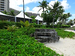
The Ipao Pillbox I is one of three surviving World War II-era fortifications on Ypao Point, located west of Tumon Bay on the west side of the island of Guam. It is built into the limestone cliff overlooking the beach on the property of the Hilton Hotel, about 17 metres (56 ft) in from the high tide line. Its walls are fashioned out of coral rock and cement, varying in thickness from 1 metre (3.3 ft) to 1.6 metres (5.2 ft). Its entrance is on the east wall, and its gun port faces north, overlooking Ypao Channel. Parts of the structure have been restored.
The Malessu' Pillbox is a World War II-era Japanese-built defensive fortification on the shore of Merizo, Guam. Located about 15 metres (49 ft) from the high-tide line at Merizo Beach, it is a rectangular structure built of steel-reinforced concrete and basalt rock. It is 3.9 metres (13 ft) deep, 2.4 metres (7.9 ft) wide, and about 2.42 metres (7.9 ft) high, although only about 0.75 metres (2.5 ft) of the structure is visible above ground. Its gun port has a view of the Merizo pier, and is approximately at ground level. It was built by Japanese defenders during their occupation of the island 1941–44.
The Mana Pillbox is an old World War II-era Japanese-built defensive fortification on the east coast of the island of Guam. It is located south of the village of Talofofo, about 50 metres (160 ft) inland from the point marking the south end of As Anite Cove. It is a structure built out of coral limestone and concrete, with an interior chamber about 3 by 1.8 metres in size. The entrance is on the south side, measuring 0.85 by 1.45 metres. There is one gun port, facing north, measuring 0.32 by .9 metres. The structure was designed to be well hidden in view from the sea and air. It was built, probably by conscripted Chamorro labor, during the Japanese occupation period 1941–44.
The Pago Bay Japanese pillboxes are a pair of World War II-era coastal defense pillboxes located on the shore of Pago Bay, located on the central east coast of Guam. Built out of steel-reinforced concrete mixed with coral stone, these two structures were built by Japanese defenders during their occupation of the island between 1941 and 1944. They were listed on the National Register of Historic Places in 1991 as Pagu' Pillbox I and Pagu' Pillbox II. Neither of these would have seen substantial action during the 1944 liberation of Guam, whose military activities were focused on the western, central, and northern parts of the island.
The San Vitores Beach Japanese Fortification are the remains of World War II-era defensive positions facing the beach of Tumon Bay on the west side of the island of Guam. Located near the stairs to the beach of the Guam Reef Hotel are the remains of two concrete pillboxes built by Japanese defenders during the occupation period 1941–44. One structure, of which little more than a gun embrasure is discernible, is located in the limestone cliff about 10 metres (33 ft) inland from the high tide line, and a second is located about 10 meters south and 8 meters further inland, with only a section of roof slab and supporting columns recognizable.
The Won Pat Outdoor Oven is a 20th-century version of a traditional hotnu, or outside oven, on the island of Guam. It is located on a vacant lot off Mansanita Court in Sinajana. Although built out of modern materials, it follows a traditional form that has been in use on Guam since these ovens were introduced by the Spanish in the 17th century. It is a barrel-shaped structure about 1.6 metres (5.2 ft) long, 1.3 metres (4.3 ft) wide, rising to a height of 0.55 metres (1.8 ft). The base of the structure is built of rough limestone and mortar. The interior of the vault is made out of heat-resistant bricks, while the exterior is finished in concrete. When recorded in 2010, its main opening was damaged.
The Talofofo Pillbox is a historic World War II-era defensive fortification in Talofofo, Guam. It is located near the coast, about 127 metres (417 ft) south of the mouth of the Togcha River and 27 metres (89 ft) inland from the high-tide line. It is roughly 2.75 by 3.0 metres, built out of concrete and coral limestone. Its walls are about 0.5 metres (1.6 ft) thick, with an embrasure providing a view of the Togcha River, and a window looking over the coast to the east. Its entrance is on the landward (south) side. This structure was built under the direction of the Imperial Japanese Army during its occupation of Guam in 1941–44.
The Tokcha' Pillbox is a Japanese-built World War II-era defensive fortification on the island of Guam. It is built on a limestone terrace on Togcha Point, about 1 mile (1.6 km) north of the Togcha River and 0.7 miles (1.1 km) south of the Ylig River. It is set in a depression excavated from the limestone about 15 metres (49 ft) inland from the high tide land and 1 metre (3.3 ft) above sea level. It is a roughly rectangular structure built out of steel-reinforced concrete filled with coral and beach aggregate. The entrance is on the north wall, sheltered by a wall of coral blocks, and the gun port is on the south wall. This structure was built under the direction of the Japanese military during their occupation of the island 1941–44.