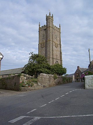
Paul is a village in Cornwall, England, United Kingdom. It is in the civil parish of Penzance. The village is two miles (3 km) south of Penzance and one mile (1.6 km) south of Newlyn.

The Botallack Mine is a former mine in Botallack in the west of Cornwall, UK. Since 2006 it has been part of the UNESCO World Heritage Site – Cornwall and West Devon Mining Landscape. The mine is within the Aire Point to Carrick Du Site of Special Scientific Interest (SSSI) and the South West Coast Path passes along the cliff.

Sancreed is a village and civil parish in Cornwall, England, United Kingdom, approximately three miles (5 km) west of Penzance.

Ludgvan is a civil parish and village in Cornwall, England, UK, 2+1⁄2 miles (4 km) northeast of Penzance. Ludgvan village is split between Churchtown, on the hill, and Lower Quarter to the east, adjoining Crowlas. For the purposes of local government, Ludgvan elects a parish council every four years; the town elects a member to Cornwall Council under the Ludgvan division.

St Agnes is a civil parish and a large village on the north coast of Cornwall, England, United Kingdom. The village is about five miles (8 km) north of Redruth and ten miles (16 km) southwest of Newquay. An electoral ward exists stretching as far south as Blackwater. The population at the 2011 census was 7,565.

Crowan is a village and civil parish in Cornwall, England, United Kingdom. It is about three-and-a-half miles (6 km) south of Camborne. A former mining parish, all of the mines had shut by 1880.

Towan is found in many placenames in Cornwall. However, The Towans usually refers to the three-mile (5 km) stretch of coastal dunes which extends north-east from the estuary of the River Hayle to Gwithian beach with a midpoint near Upton. The South West Coast Path crosses the towans.

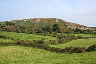
Gurnard's Head is a prominent headland on the north coast of the Penwith peninsula in Cornwall, England. The name is supposed to reflect that the rocky peninsula resembles the head of the gurnard fish.
Belowda is a village in Cornwall, England, UK. The village is just north of the A30 trunk road, about seven miles west-southwest of Bodmin. The village also gives its name to the nearby Belowda Beacon. It is in the civil parish of Roche.

Troon is a village in Cornwall, UK, 1+1⁄2 miles southeast of Camborne. The village lies at around 560 feet (170 m) above sea level. An electoral ward named Troon and Beacon covers the area north from Troon to the outskirts of Camborne. The population at the 2011 census was 5,410.
Caer Bran Hill Fort is an archaeological site near Sancreed and Carn Euny Iron Age village, on the Penwith peninsula in Cornwall.
Trencrom Hill is a prominent hill fort, owned by the National Trust, near Lelant, Cornwall. It is crowned by an univallate Neolithic tor enclosure and was re-used as a hillfort in the Iron Age. Cairns or hut circles can be seen in the level area enclosed by the stone and earth banks. The hill overlooks the Hayle Estuary and river, and Mount's Bay and St Michael's Mount can be seen to the south. The hill was recorded as Torcrobm in 1758 which is derived from Cornish "torr crobm", i.e. 'hunched bulge'.

Trink Hill is a 212-metre-high hill that lies between the hamlets of Trink and Cripplesease, near to the village of Nancledra, Cornwall, UK. Trencrom Hill lies one kilometre to the South East.
Carnebone is a small hamlet and farm in the parish of Wendron in Cornwall, England. It lies to the east of Wendron, to the northeast of Trevenen, just to the west of Seworgan, along the A394 road, 3.8 miles (6.1 km) northeast of Helston.

Degibna is a hamlet and farm in the parish of Helston, Cornwall, England, UK. It lies on the eastern bank of the largest natural freshwater lake in Cornwall, The Loe, and forms part of the Penrose Estate.

Grumbla is a hamlet in the parish of Sancreed, Cornwall, England, UK.

Holmbush is a village in Cornwall, England that is situated in the suburban area of St Austell. It was a centre for tin and copper mining in the eighteenth and nineteenth centuries, with a few houses to the south of the A390 road. It was developed in the 1970s, with the construction of housing and an industrial estate to the north of the road. Since 1974, the site of Cuddra mine has been developed as Pinetum Gardens, an attraction holding over 6,000 varieties of plants, many collected by the owner on plant hunting expeditions.

Pennance is a hamlet near Lanner in west Cornwall, England.

Prospidnick is a small village and hill in the parish of Sithney in Cornwall, United Kingdom. It lies 0.6 miles east of Crowntown and 2.6 miles west of Wendron by road. It is divided into Lower Prospidnick and Higher Prospidnick.

The A3071 is a minor 'A' road in the English county of Cornwall, which links St Just to Penzance and the A30. It is 6.2 miles long.