Sand, Texas | |
|---|---|
 Sand, Texas Location in Texas | |
| Coordinates: 32°42′15″N102°10′21″W / 32.7042648°N 102.1723893°W | |
| Country | United States |
| State | Texas |
| County | Dawson |
| Elevation | 3,028 ft (923 m) |
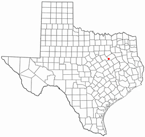
Sand is a ghost town in Dawson County, Texas, United States. [1]
Sand, Texas | |
|---|---|
| Sand, Texas Location in Texas | |
| Coordinates: 32°42′15″N102°10′21″W / 32.7042648°N 102.1723893°W | |
| Country | United States |
| State | Texas |
| County | Dawson |
| Elevation | 3,028 ft (923 m) |
Sand is a ghost town in Dawson County, Texas, United States. [1]
Sand is situated on U.S. Route 180, and is named for the surrounding sand dunes. A post office opened in 1935, with Ebbie Lee as postmaster, and closed on July 30, 1955, and became a substation of Lamesa. In 1990, the population was 20. [2]

Yoakum County is a county located in the far western portion of the U.S. state of Texas. As of the 2020 census, the population was 7,694. Its county seat is Plains. The county was created in 1876 and later organized in 1907. It is named for Henderson King Yoakum, a Texas historian.

Terry County is a county located in the U.S. state of Texas. As of the 2020 census, its population was 11,831. Its county seat is Brownfield. The county was demarked in 1876 and organized in 1904. It is named for Benjamin Franklin Terry, a colonel in the Confederate Army. Terry County was one of 46 dry counties in the state of Texas, but is now a moist county. Terry County is one of the most productive pumpkin producing counties in the United States.

Refugio County is a county located in the U.S. state of Texas. As of the 2020 census, its population was 6,741. Its county seat is Refugio. The county originated as a municipality of Mexico in 1834 and was classified as a county in 1837.
Martin County is a county in the U.S. state of Texas. As of the 2020 census, its population was 5,237. Its county seat is Stanton. The county was created in 1876 and organized in 1884. It is named for Wylie Martin, an early settler.

Lynn County is a county in the U.S. state of Texas. As of the 2020 census, its population was 5,596. Its county seat is Tahoka. The county was created in 1876 and organized in 1903.

Howard County is a county located in the U.S. state of Texas. At the 2020 census, its population was 34,860. Its county seat is Big Spring. The county was created in 1876 and organized in 1882. It is named for Volney E. Howard, a U.S. Congressman from Texas.

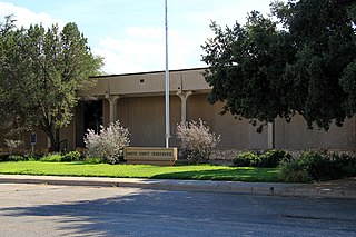
Dawson County is a county in the U.S. state of Texas. As of the 2020 census, its population was 12,456. The county seat is Lamesa. The county was created in 1876 and later organized in 1905. It is named for Nicholas Mosby Dawson, a soldier of the Texas Revolution. Dawson County comprises the Lamesa, TX Micropolitan Statistical Area (μSA), and it is, by population, the smallest Micropolitan Statistical Area in the United States.

Kalkaska County is located in the U.S. state of Michigan. As of the 2020 census, its population was 17,939. The county seat is Kalkaska.

Dawson County is a county located in the northeast region of the U.S. state of Georgia. As of the 2020 census, the population was 26,798 up from 22,330 in 2010. The county seat is Dawsonville.
Saguache County is a county located in the U.S. state of Colorado. As of the 2020 census, the population was 6,368. The county seat is Saguache.

Lamesa is a city in and the county seat of Dawson County, Texas, United States. The population was 8,674 at the 2020 census, down from 9,952 at the 2000 census. Located south of Lubbock on the Llano Estacado, Lamesa was founded in 1903. Most of its economy is based on cotton farming. The Preston E. Smith prison unit, named for the former governor of Texas, is located just outside Lamesa.
Dawson is a town in Navarro County, in the U.S. state of Texas. The population was 815 at the 2020 census.

The Colorado River is an approximately 862-mile-long (1,387 km) river in the U.S. state of Texas. It is the 11th longest river in the United States and the longest river with both its source and its mouth within Texas.

The geography of Texas is diverse and large. Occupying about 7% of the total water and land area of the U.S., it is the second largest state after Alaska, and is the southernmost part of the Great Plains, which end in the south against the folded Sierra Madre Oriental of Mexico. Texas is in the South Central United States of America, and is considered to form part of the U.S. South and also part of the U.S. Southwest.

Monument Hill and Kreische Brewery State Historic Sites are two state historic sites managed by the Texas Historical Commission. They are located at 29.888° -96.876°, just off U.S. Route 77, south of La Grange, Texas. The sites sit on a sandstone bluff 200 feet above the Colorado River. Monument Hill is a memorial to the men who died in the Dawson Massacre and in the Black Bean Episode of the ill-fated Mier Expedition.
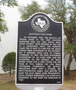
The Dawson massacre, also called the Dawson expedition, was an incident in which 36 Texian militiamen were killed by Mexican soldiers on September 17, 1842 near San Antonio de Bexar. The event occurred during the Battle of Salado Creek, which ended with a Texian victory. This was among numerous armed conflicts over the area between the Rio Grande and Nueces rivers, which the Republic of Texas tried to control after achieving independence in 1836.
Sand Ridge is an unincorporated community in Wharton County, Texas, United States. It is located within the Greater Houston metropolitan area.
Sand Flat is an unincorporated community in Johnson County, Texas, United States. It is located along Farm to Market Road 4 (FM 4) in the southeastern part of the county, roughly midway between Cleburne and Grandview and just over one mile (1.6 km) north-northeast of the unincorporated community of Cuba.
Sand is a ghost town in Bastrop County, Texas, United States.
Municipalities and communities of Dawson County, Texas, United States | ||
|---|---|---|
| Cities |  | |
| CDP | ||
| Other communities | ||
| Ghost towns | ||
| Footnotes | ‡This populated place also has portions in an adjacent county or counties | |