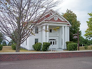
Eagle River is an unincorporated community and census-designated place in the U.S. state of Michigan and is the county seat of Keweenaw County. Its population was 71 as of the 2010 census. It is by far the least-populated county seat in the state of Michigan.
The Mineral River is an 18.7-mile-long (30.1 km) tributary of Lake Superior on the western Upper Peninsula of Michigan in the United States. It flows for its entire length in western Ontonagon County, rising in the Ottawa National Forest and flowing generally northward to meet Lake Superior about 11 miles (18 km) west-southwest of Ontonagon. The United States Board on Geographic Names settled on "Mineral River" as the stream's name in 1976; according to the Geographic Names Information System it has also been known historically as "Beaver Creek".
The Black River is a 41.1-mile-long (66.1 km) river on the Upper Peninsula of the U.S. state of Michigan, flowing mostly in Gogebic County into Lake Superior at 46°40′03″N90°02′57″W. Its source at 46°18′54″N90°01′15″W is a boreal wetland on the border with Iron County, Wisconsin. The northern section of the river, 14 miles (23 km) within the boundaries of the Ottawa National Forest, was designated a National Wild and Scenic River in 1992.

The Ontonagon River is a river flowing to Lake Superior on the western Upper Peninsula of Michigan in the United States. The main stem of the river is 25 miles (40 km) long and is formed by a confluence of several longer branches, portions of which have been collectively designated as a National Wild and Scenic River. Several waterfalls occur on the river including Agate Falls and Bond Falls.
The Manistique River is a 71.2-mile-long (114.6 km) river in the U.S. state of Michigan that winds southward through the central Upper Peninsula from its headwaters near Lake Superior to its mouth in Lake Michigan. It drains approximately 1,461 square miles (3,780 km2) of the Upper Peninsula, including most of Schoolcraft County and small portions of Alger County, Delta County, Luce County, and Mackinac County. The river rises at the outlet of Manistique Lake in the southwest corner of Luce County, and after flowing through the Seney National Wildlife Refuge, empties into Lake Michigan at Manistique, Michigan. M-77, a north-south highway, serves much of the Manistique River's drainage and crosses the river and its tributaries several times.

The Au Train River is a 16.8-mile-long (27.0 km) river in Au Train Township, Alger County, Michigan. It rises at the outlet of Cleveland Cliffs Basin, a reservoir, and flows north, passing through Au Train Lake, and entering Lake Superior at the village of Au Train.
The Big Garlic River is a 14.4-mile-long (23.2 km) river in Marquette County, Michigan. It empties into Lake Superior.
The Blind Sucker River is a 10.8-mile-long (17.4 km) river in northwestern Luce County on the Upper Peninsula of Michigan in the United States. It is a tributary of Lake Superior.
The Hurricane River is a 6.4-mile-long (10.3 km) river in Alger County in the Upper Peninsula of Michigan in the United States. It empties into Lake Superior in the Pictured Rocks National Lakeshore. There is a campground at the mouth of the river which is also the beginning of a trail that leads past various old shipwrecks to the historic Au Sable Lighthouse. The mouth of the river is also very near the eastern end of a stretch of relatively straight shoreline known as Twelvemile Beach.
The Iron River is a 2.7-mile-long (4.3 km) river in Marquette County on the Upper Peninsula of Michigan in the United States. It is a short stream flowing from the outlet of Lake Independence east to Lake Superior.
The Little Two Hearted River is a 23.9-mile-long (38.5 km) river in Luce County on the Upper Peninsula of Michigan in the United States. It rises at the outlet of the Little Two Hearted Lakes at the southern border of Lake Superior State Forest and flows generally north to Lake Superior.
The Miners River is a river on the Upper Peninsula of Michigan in the United States. It is the largest river in the Pictured Rocks National Lakeshore. Miners River has its origin outside of the National Lakeshore, north of Indian Town in the Hiawatha National Forest, and flows 12.4 miles (20.0 km) into Lake Superior. Miners Lake and Miners Falls are found along the river. The river empties into Lake Superior at the western end of Miners Beach. It is popular for tourism and fishing.
The Mosquito River is a 6.7-mile-long (10.8 km) stream in Alger County in the Upper Peninsula of Michigan, United States. It is a tributary of Lake Superior along the Pictured Rocks National Lakeshore.
The Murphy River is a 6.6-mile-long (10.6 km) river in Baraga County on the Upper Peninsula of Michigan in the United States. It is a tributary of Worm Lake, the outlet of which is the Rock River, which flows to the Sturgeon River and eventually to Lake Superior.
The Sucker River is a 34.8-mile-long (56.0 km) river in eastern Alger County on the Upper Peninsula of Michigan in the United States. It rises at the outlet of Nawakwa Lake and flows generally north to Lake Superior east of Grand Marais.
The Tobacco River is a 14.0-mile-long (22.5 km) river in Keweenaw County on the Upper Peninsula of Michigan in the United States. It rises at the outlet of Thayer Lake and flows east, then south, to Lake Superior, which it joins near the village of Gay.
The Vermilac River is an 8.8-mile-long (14.2 km) river in Baraga County on the Upper Peninsula of Michigan in the United States. It is a tributary of Worm Lake, the outlet of which is the Rock River, which flows to the Sturgeon River and eventually to Lake Superior.
The Carp River is a 1.2-mile-long (1.9 km) stream in the northeast corner of Luce County on the Upper Peninsula of Michigan in the United States. It flows west from the outlet of Browns Lake, to its mouth on Lake Superior.
The Tamarack River is an 8.8-mile-long (14.2 km) tributary of the Middle Branch Ontonagon River in Iron and Gogebic counties on the Upper Peninsula of Michigan in the United States. The stream source is the outflow from Tamarack Lake. Via the Middle Branch of the Ontonagon River, its water flows north to the Ontonagon River and ultimately to Lake Superior.


