
Navajo Bridge is a pair of steel spandrel arch bridges that cross the Colorado River near Lee's Ferry in northern Arizona. The newer bridge of the pair carries vehicular traffic on U.S. Route 89A (US 89A) over Marble Canyon between southern Utah and the Arizona Strip, allowing travel into a remote region north of the Colorado River including the North Rim of Grand Canyon National Park.

The Memphis & Arkansas Bridge, also known as the Memphis–Arkansas Bridge or Memphis–Arkansas Memorial Bridge, is a cantilevered through truss bridge carrying Interstate 55 across the Mississippi River between West Memphis, Arkansas and Memphis, Tennessee. Memphians refer to this bridge as the "Old Bridge" to distinguish it from the "New Bridge", or Hernando de Soto Bridge, upstream.
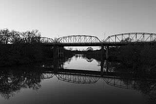
The Colorado River Bridge at Bastrop is a 1,285-foot (392 m)-long bridge with three steel truss spans and concrete piers that crosses the Colorado River as part of Loop 150 through Bastrop, Texas. The three bridge spans over the river consist of identical Parker through trusses, each 192 feet (59 m) in length, supported on concrete piers. The bridge is one of the earliest surviving uses of the Parker truss in Texas.

The Mount Orne Bridge is a covered bridge over the Connecticut River between Lancaster, New Hampshire, and Lunenburg, Vermont. It joins Elm Street in South Lancaster with River Road in Lunenburg. Built in 1911, it is one of two Howe truss bridges across the Connecticut River. It was listed on the National Register of Historic Places in 1976.

The Cedar Canyon Bridge is a steel arch highway bridge on US 60 (US 60) near Show Low, Arizona. The 180-foot (55 m) span ribbed girder arch bridge was built in 1937–38 with a total length of 250 feet (76 m). The 24-foot-wide (7.3 m) bridge was substantially widened and upgraded in 1994, using the identical arch from the Corduroy Creek Bridge to double the width of the bridge while rehabilitating the deck structure.

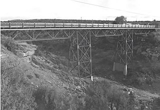
The Corduroy Creek Bridge was a steel arch highway bridge on US 60, located near Show Low, Arizona in Navajo County, Arizona.

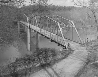
The Rio Puerco Bridge is a Parker through truss bridge located on historic U.S. Route 66 (US 66), crossing the Rio Puerco, that was built in 1933. It is located approximately 19 miles (30 km) west of Albuquerque, New Mexico.
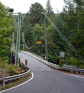
The Yale Bridge or Lewis River Bridge spans the Lewis River near Yale, Washington. It was built in 1932 by Cowlitz and Clark counties. The suspension bridge has a clear span of 300 feet (91 m), with a total length of 532 feet (162 m), replacing a previous steel truss bridge at the site. Construction of the Ariel Dam had created Lake Merwin with a water depth of 90 feet (27 m) at the site, requiring a new bridge that did not need to have support piers in the water. The road deck, stiffened by a steel Warren truss, is 50 feet (15 m) above the high water line of the reservoir.
The Jefferson Street Viaduct is an historic structure located in Ottumwa, Iowa, United States. The riveted Warren deck truss bridge was completed in 1936. It was listed on the National Register of Historic Places in 1998 as a part of the Highway Bridges of Iowa MPS.

The Cameron Suspension Bridge crosses the Little Colorado River at Cameron, Arizona, United States.

The US 12–St. Joseph River Bridge is a three-span camelback bridge in Mottville, Michigan, that carried U.S. Route 12 across the St. Joseph River. Built in 1922, it is the fourth bridge to cross the river at this location. It has served as a pedestrian bridge since 1990 when a new bridge opened alongside to carry the highway. The bridge is the longest surviving camelback bridge in Michigan. It is a Michigan State Historic Site and is listed on the National Register of Historic Places.

The AJX Bridge is a historic Pratt truss bridge in southwestern Johnson County, Wyoming. The bridge was built in 1931 across the South Fork of the Powder River near Kaycee, Wyoming. AJX Bridge was built to provide a river crossing for U.S. Route 87. It was placed on the National Register of Historic Places in 1985 as part of a Multiple Property Submission devoted to historic bridges in Wyoming.
Clarkton Bridge was a historic Pratt truss bridge located over the Staunton River near Nathalie, in Charlotte County, Virginia. It was built in 1902 by the Virginia Bridge & Iron Co., and was the only remaining metal truss structure in Virginia built for highway purposes, which was supported by steel cylinder piers. It consisted of two camelback, pin-connected steel through truss channel spans, and twelve steel deck beam approach spans. The overall dimensions of the bridge approach and truss spans were as follows: north approach, 370 feet (110 m) with twelve deck spans; north truss, 150 feet (46 m); south truss, 150 feet (46 m). The total length of the bridge was 692 feet (211 m).

The Bloomfield-Nulhegan River Route 102 Bridge is a historic bridge in Bloomfield, Vermont. It carries Vermont Route 102 over the Nulhegan River, near its mouth at the Connecticut River just south of Bloomfield Village. Built in 1937, it is a well-preserved example of a Pratt through truss, exhibiting then state-of-the-art engineering. It was listed on the National Register of Historic Places in 1991.

The Ocean-to-Ocean Bridge is a through truss bridge spanning the Colorado River in Yuma, Arizona. Built in 1915, it was the first highway crossing of the lower Colorado and is the earliest example of a through truss bridge in Arizona. It is also the only example of a Pennsylvania truss within Arizona. Originally the bridge carried the transcontinental Ocean-to-Ocean Highway and later carried its successor, US 80 until a new bridge was built to the west in 1956. Between 1988 and 2001, the bridge was closed to vehicular traffic and only traversable by pedestrians and bicyclists. After a major restoration, the bridge was rehabilitated and reopened to vehicular traffic in 2002, with a re-dedication by the Quechan nation and Yuma Crossing National Heritage Area. The bridge became part of Historic US 80 in 2018.

Bridge 12 is a historic Parker through truss bridge, carrying Boston Post Road across the Missisquoi River in Enosburg, Vermont. Built in 1929 in the wake of Vermont's devastating 1927 floods, it is one a shrinking number of surviving truss bridges on the river. It was listed on the National Register of Historic Places in 2007.

The Hassayampa Bridge is a bridge spanning the Hassayampa River in Hassayampa, Arizona, located in Maricopa County. The bridge was completed in 1929 and was listed on the National Register of Historic Places in 1988. The bridge was scheduled for demolition in 1983.

The Allentown Bridge is a bridge spanning the Puerco River near Houck, Arizona, located in Apache County. The existing structure was completed in 1923 and is listed on the National Register of Historic Places.

The Gillespie Dam Bridge is a through truss bridge spanning the Gila River in Maricopa County, in the U.S. state of Arizona. The bridge was constructed to bypass a concrete apron through the river in front of the Gillespie Dam, which was often closed due to flooding. Construction of the bridge started in 1925 and completed in 1927. From its opening until 1956, the bridge was part of U.S. Route 80 (US 80), a transcontinental highway between San Diego, California and Tybee Island, Georgia. The bridge was restored in 2012 by Maricopa County for the Arizona Centennial and now includes an educational interpretive center for visitors. The bridge became part of Historic US 80 in 2018.
Querino Canyon Bridge is located approximately 4 miles (6.4 km) southwest of Houck, Arizona, on Old Route 66, over Querino Canyon. It is within the boundaries of the Petrified Forest National Park.

