
Mount Graham is a mountain in Graham County, Arizona, United States, approximately 70 miles (110 km) northeast of Tucson. The mountain reaches 10,720 feet (3,267 m) in height. It is the highest elevation in Graham County, Coronado National Forest and the Pinaleño Mountains. It is also the southernmost peak and land area in the continental United States above 10,000 feet (3,048 m). As the name "Mount Graham" is often used by locals to refer to the entire mountain range, the peak itself is frequently referred to as "High Peak". It is twentieth of the 57 ultra-prominent peaks of the lower 48 states, and the first of the five in Arizona.

Tortilla Flat is a small unincorporated community in far eastern Maricopa County, Arizona, United States. The mayor is Lisa Schmidt Smith. It is located in the central part of the state, northeast of Apache Junction. It is the last surviving stagecoach stop along the Apache Trail. According to the Gross Management Department of Arizona's main U.S. Post Office in Phoenix, Tortilla Flat is presumed to be Arizona's smallest official "community" having a U.S. Post Office and voting precinct. The town has a population of 6. Tortilla Flat can be reached by vehicles on the Apache Trail, via Apache Junction.

Two Guns is a ghost town in Coconino County, Arizona, United States. Located on the east rim of Canyon Diablo about 30 mi (48 km) east of Flagstaff, Two Guns prospered as a tourist stop along Route 66.

This is a list of the National Register of Historic Places listings in Apache County, Arizona. It is intended to be a complete list of the properties and districts on the National Register of Historic Places in Apache County, Arizona, United States. The locations of National Register properties and districts for which the latitude and longitude coordinates are included below, may be seen in a map.
The Pinedale Ranger Station is in the Apache-Sitgreaves National Forests, and located near Pinedale in Navajo County, Arizona.

Carrizo is a census-designated place in Gila County, Arizona, United States, located on the Fort Apache Indian Reservation.
The Querino Canyon Bridge is located approximately four miles (6.4 km) southwest of Houck, Arizona, on Old Route 66, over Querino Canyon.
Sanders Bridge is a steel truss bridge straddling the Puerco River, near Sanders, Arizona. It was constructed in 1923 and gained National Historic status in 1988.
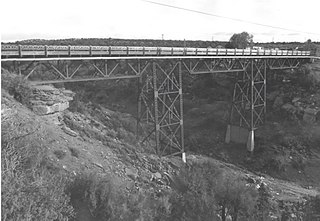
The Black River Bridge near Carrizo, Arizona was funded in 1911 and built in 1912. It was listed on the National Register of Historic Places in 1988. It spans the Black River, bringing an army road, now Indian Route 9, over the river from Fort Apache to the railroad at the former town of Rice, Arizona.


