Sanderson, Florida

Last updated

Sanderson, Florida
SandersonFL14.JPG
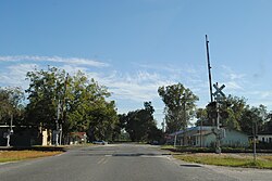
Southbound on Baker CR 229 at the Tallahassee Subdivision Railroad Crossing.
USA Florida location map.svg
Red pog.svg
Sanderson, Florida
Coordinates: 30°15′08″N82°16′22″W / 30.25222°N 82.27278°W / 30.25222; -82.27278
Country United States
State Florida
County Baker
Elevation
157 ft (48 m)
Time zone UTC-5 (Eastern (EST))
  Summer (DST) UTC-4 (EDT)
ZIP code
32087 [1]
Area code 904
GNIS feature ID306352 [2]

Sanderson is an unincorporated community in Baker County, Florida, United States. The main road through Sanderson is U.S. Route 90, which is intersected by County Roads 229 and 127. Sanderson is also the headquarters of the Baker County Road Department. The town was named after John Pease Sanderson.

Sanderson is home to a cannabis cultivation facility, as well as several other small manufacturing concerns, due to the towns easy access to I10.

Related Research Articles

<span class="mw-page-title-main">Baker County, Florida</span> County in Florida, United States

Baker County is a county in the U.S. state of Florida. As of the 2020 census, the population was 28,259. Its county seat is Macclenny. The county was founded in 1861 and is named for James McNair Baker, a judge and Confederate Senator.

<span class="mw-page-title-main">Lake County, Florida</span> County in Florida, United States

Lake County is a county in the central portion of the U.S. state of Florida. As of the 2020 census, the population was 383,956. Its county seat is Tavares, and its largest city is Clermont. Lake County is included in the Orlando–Kissimmee–Sanford Metropolitan Statistical Area.

<span class="mw-page-title-main">Sarasota County, Florida</span> County in Florida, United States

Sarasota County is a county located in Southwest Florida. At the 2020 US census, the population was 434,006. Its county seat is Sarasota and its largest city is North Port. Sarasota County is part of the North Port–Bradenton–Sarasota, FL metropolitan statistical area.

<span class="mw-page-title-main">Union County, Florida</span> County in Florida, United States

Union County is a county located in the north central portion of the U.S. state of Florida, the smallest in the state by area. As of the 2020 census, the population was 16,147. The county seat is Lake Butler.

<span class="mw-page-title-main">Gainesville, Florida</span> City in Florida, United States

Gainesville is the county seat of Alachua County, Florida, United States, and the most populous city in North Central Florida, with a population of 145,212 in 2022. It is the principal city of the Gainesville metropolitan area with a population of 350,903 in 2022.

<span class="mw-page-title-main">Macclenny, Florida</span> City in Florida, United States

Macclenny is a city and the county seat of Baker County, Florida. Located just west of Jacksonville, it is part of the Jacksonville, Florida Metropolitan Statistical Area. The population was 7,304 at the 2020 census, up from 6,374 in 2010.

<span class="mw-page-title-main">Weston, Florida</span> City in Florida, United States

Weston is a city in Broward County, Florida, United States, just west of Fort Lauderdale. It is 31 miles (50 km) to the northwest of Miami and part of the Miami metropolitan area. The population was 68,107 at the 2020 census.

<span class="mw-page-title-main">Inverness, Florida</span> City in Florida, United States

Inverness is a city and the county seat of Citrus County, Florida, United States. It is near the 10,950-acre (4,430 ha) Flying Eagle Preserve. As of the 2020 census, the population was 7,543, up from 7,210 at the 2010 census. It is part of the Homosassa Springs, Florida Metropolitan Statistical Area.

<span class="mw-page-title-main">Windermere, Florida</span> Town in Florida, United States

Windermere is a town in Orange County, Florida, United States. As of the 2020 census, the town population was 3,030. It is part of the Orlando Metropolitan Statistical Area.

<span class="mw-page-title-main">Venice, Florida</span> City in Florida, United States

Venice is a city in Sarasota County, Florida, United States. The city includes what locals call "Venice Island", a portion of the mainland that is accessed via bridges over the artificially created Intracoastal Waterway. The city is located in Southwest Florida. As of the 2020 Census, the city had a population of 25,463, up from 20,748 at the 2010 Census. Venice is part of the North Port–Bradenton–Sarasota, Florida Metropolitan Statistical Area.

<span class="mw-page-title-main">Huntsville, Tennessee</span> Town in Tennessee, United States

Huntsville is a town in Scott County, Tennessee, United States. The population was 1,270 at the 2020 census and 1,248 at the 2010 census. It is the county seat of Scott County.

<span class="mw-page-title-main">Sanderson, Texas</span> CDP in Texas, United States

Sanderson is a census-designated place (CDP) in and the county seat of Terrell County, Texas, United States. The population was 664 at the 2020 census. Sanderson was created in 1882 as a part of neighboring Pecos County. It became the seat of Terrell County in 1905.

<span class="mw-page-title-main">Olustee, Florida</span> Unincorporated area in Florida, United States

Olustee is an unincorporated area in Baker County, Florida, United States. The name "Olustee" is from the nearby Olustee Creek whose name derives from the Creek (Muscogee) language ue-lvste (/oy-lást-i/) meaning "black water". The town was historically known as Olustee Station and is the location of the Olustee Battlefield Historic State Park and of the ranger station for the Osceola National Forest, which is headquartered there. The US Forest Service has restored the former railroad depot at the center of town as a visitor center and museum for forest visitors.

Harker was an unincorporated community located in Collier County, Florida, United States, about 40 kilometres (25 mi) East of the city of Bonita Springs and 8 kilometres (5.0 mi) Southeast of the town of Immokalee. Most maps indicate that Harker is located on State Road 29 between West Main Street to the North and Oil Well Road to the South. West of Harker is Summerland Swamp, and to the East is the Okaloacoochee Slough.

<span class="mw-page-title-main">Aripeka, Florida</span> Census-designated place & Unincorporated Community in Florida, United States

Aripeka is an unincorporated community and census-designated place (CDP) in the U.S. state of Florida, along the coast of the Gulf of Mexico at the border dividing Pasco and Hernando counties. The ZIP Code for the community is 34679, but it was originally assigned as 33502. As of the 2020 census, the population was 320.

<span class="mw-page-title-main">Baker, Florida</span> Unincorporated community in Florida, United States

Baker is an unincorporated community in Okaloosa County, Florida, United States. It is located approximately 10 miles (16 km) northwest of the county seat, Crestview, in the Florida Panhandle. A stop on the Florida, Alabama and Gulf Railroad, Baker was platted in 1910 and grew up around the timber and turpentine industries.

McDavid is an unincorporated community in Escambia County, Florida, United States. The community is part of the Pensacola – Ferry Pass – Brent, Florida Metropolitan Statistical Area. The ZIP Code for McDavid is 32568.

<span class="mw-page-title-main">Oxford, Florida</span> Unincorporated community in Florida, United States

Oxford is an unincorporated community in Sumter County, Florida, United States. Its ZIP code is 34484.

Verna is an unincorporated area in Manatee County and Sarasota County, Florida, United States.

Point Baker is an unincorporated community and census-designated place in Santa Rosa County, Florida, United States. Its population was 2,991 as of the 2010 census. Florida State Road 87 and Florida State Road 89 intersect in Point Baker.

References

  1. "Sanderson ZIP Code". zipdatamaps.com. 2022. Retrieved November 30, 2022.
  2. "Sanderson". Geographic Names Information System . United States Geological Survey, United States Department of the Interior.