Glen St. Mary, Florida

Last updated

Glen St. Mary, Florida
Town of Glen St. Mary
GlenStMaryMontage1.png
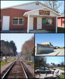
Top, left to right: Glen St. Mary Town Hall, CSX Tallahassee Subdivision railroad, Baker County High School, Celebration Park
Baker County Florida Incorporated and Unincorporated areas Glen St. Mary Highlighted.svg
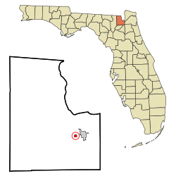
Location in Baker County and the state of Florida
Coordinates: 30°16′34″N82°9′41″W / 30.27611°N 82.16139°W / 30.27611; -82.16139
Country Flag of the United States.svg  United States
State Flag of Florida.svg  Florida
County   Baker
Government
  Type Mayor-Council
   Mayor Juanice Padgett
   Council Members Terry Clardy,
Andrew "Drew" Vetter,
Lola Chandler, and
Susan Wallace
   Town Clerk Jolene G. Kirkland
   City Attorney Jonathan Bense
Area
[1]
  Total0.46 sq mi (1.19 km2)
  Land0.46 sq mi (1.19 km2)
  Water0.00 sq mi (0.00 km2)
Elevation
131 ft (40 m)
Population
 (2020)
  Total463
  Density1,010.92/sq mi (390.47/km2)
Time zone UTC-5 (Eastern (EST))
  Summer (DST) UTC-4 (EDT)
ZIP code
32040 [2]
FIPS code 12-26075 [3]
GNIS feature ID0283111 [4]
Website glenstmary.govoffice.com

Glen St. Mary is a town in Baker County, Florida, United States. The Town of Glen St. Mary is part of the Jacksonville metropolitan area in North Florida. In 2020, the population recorded by the U.S. Census Bureau was 463. [5]

Contents

Geography

The exact location coordinates for the Town of Glen St. Mary are 30°16′34″N82°9′41″W / 30.27611°N 82.16139°W / 30.27611; -82.16139 (30.275987, –82.161408). [6]

U.S. Route 90 (Mount Vernon Avenue) runs through the center of town, and Interstate 10 passes through south of the town, with access from Exit 333 (Baker County Road 125).

According to the United States Census Bureau, the town has a total area of 0.4 square miles (1.0 km2), all land.

Climate

The climate in this area is characterized by hot, humid summers and generally mild winters. According to the Köppen climate classification, the Town of Glen St. Mary has a humid subtropical climate zone (Cfa).

Climate data for Glen St. Mary, Florida, 1991–2020 normals, extremes 1919present
MonthJanFebMarAprMayJunJulAugSepOctNovDecYear
Record high °F (°C)89
(32)
89
(32)
91
(33)
95
(35)
102
(39)
104
(40)
102
(39)
100
(38)
99
(37)
97
(36)
90
(32)
86
(30)
104
(40)
Mean maximum °F (°C)79.6
(26.4)
81.9
(27.7)
85.3
(29.6)
88.6
(31.4)
93.0
(33.9)
96.4
(35.8)
96.2
(35.7)
95.4
(35.2)
93.2
(34.0)
89.3
(31.8)
84.6
(29.2)
81.0
(27.2)
97.8
(36.6)
Mean daily maximum °F (°C)67.1
(19.5)
70.6
(21.4)
75.9
(24.4)
81.7
(27.6)
87.6
(30.9)
91.1
(32.8)
92.8
(33.8)
91.8
(33.2)
88.8
(31.6)
82.5
(28.1)
75.0
(23.9)
69.4
(20.8)
81.2
(27.3)
Daily mean °F (°C)53.5
(11.9)
57.1
(13.9)
61.8
(16.6)
67.5
(19.7)
74.2
(23.4)
79.8
(26.6)
82.0
(27.8)
81.6
(27.6)
78.6
(25.9)
70.6
(21.4)
62.1
(16.7)
56.2
(13.4)
68.7
(20.4)
Mean daily minimum °F (°C)40.0
(4.4)
43.7
(6.5)
47.7
(8.7)
53.3
(11.8)
60.7
(15.9)
68.5
(20.3)
71.2
(21.8)
71.4
(21.9)
68.3
(20.2)
58.7
(14.8)
49.2
(9.6)
42.9
(6.1)
56.3
(13.5)
Mean minimum °F (°C)23.6
(−4.7)
26.7
(−2.9)
30.0
(−1.1)
38.0
(3.3)
47.2
(8.4)
59.8
(15.4)
64.9
(18.3)
64.8
(18.2)
57.7
(14.3)
41.8
(5.4)
30.6
(−0.8)
27.6
(−2.4)
21.4
(−5.9)
Record low °F (°C)7
(−14)
14
(−10)
9
(−13)
27
(−3)
37
(3)
45
(7)
54
(12)
52
(11)
40
(4)
29
(−2)
18
(−8)
9
(−13)
7
(−14)
Average precipitation inches (mm)3.68
(93)
3.51
(89)
3.71
(94)
3.10
(79)
2.87
(73)
8.42
(214)
6.76
(172)
7.12
(181)
5.84
(148)
3.65
(93)
1.93
(49)
2.63
(67)
53.22
(1,352)
Average precipitation days (≥ 0.01 in)8.27.67.75.96.313.513.914.510.26.85.56.2106.3
Source: NOAA [7] [8]

Demographics

Historical population
CensusPop.Note
1960 329
1970 3578.5%
1980 46229.4%
1990 4803.9%
2000 473−1.5%
2010 437−7.6%
2020 4635.9%
U.S. Decennial Census [5]

2010 and 2020 census

Glen St. Mary racial composition
(Hispanics excluded from racial categories)
(NH = Non-Hispanic)
RacePop 2010 [9] Pop 2020 [10] % 2010% 2020
White (NH)40741293.14%88.98%
Black or African American (NH)10172.29%3.67%
Native American or Alaska Native (NH)200.46%0.00%
Asian (NH)300.69%0.00%
Pacific Islander or Native Hawaiian (NH)000.00%0.00%
Some other race (NH)000.00%0.00%
Two or more races/Multiracial (NH)7211.60%4.54%
Hispanic or Latino (any race)8131.83%2.81%
Total437463

As of the 2020 United States census, there were 463 people, 238 households, and 162 families residing in the town. [11]

As of the 2010 United States census, there were 437 people, 203 households, and 163 families residing in the town. [12]

2000 census

At the 2000 census, [3] there were 473 people, 181 households and 131 families residing in the town. The population density was 1,127.1 inhabitants per square mile (435.2/km2). There were 196 housing units at an average density of 467.0 per square mile (180.3/km2). The racial makeup of the town was 97.89% White, 0.63% African American, 0.42% Native American, 0.63% Asian, and 0.42% from two or more races. Hispanic or Latino of any race were 1.90% of the population.

In 2000, there were 181 households, of which 45.9% had children under the age of 18 living with them, 54.1% were married couples living together, 16.51% had a female householder with no husband present, and 27.1% were non-families. 24.9% of all households were made up of individuals, and 11.6% had someone living alone who was 65 years of age or older. The average household size was 2.61 and the average family size was 3.2.

In 2000, 30.4% of the population were under the age of 18, 9.9% from 18 to 24, 25.8% from 25 to 44, 23.5% from 45 to 64, and 10.4% who were 65 years of age or older. The median age was 32 years. For every 100 females, there were 90.0 males. For every 100 females age 18 and over, there were 85.9 males.

In 2000, the median household income was $28,906 and the median family income was $29,833. Males had a median income of $23,182 and females $20,625. The per capita income was $12,954. About 14.5% of families and 12.7% of the population were below the poverty line, including 28.7% of those under age 18 and 12.8% of those age 65 or over.

Education

The public schools in the Town of Glen St. Mary are served by the Baker County School District.

Related Research Articles

<span class="mw-page-title-main">Macclenny, Florida</span> City in Florida, United States

Macclenny is a city and the county seat of Baker County, Florida. Located just west of Jacksonville, it is one of the principal municipalities comprising Greater Jacksonville. The population was 7,304 at the 2020 census, up from 6,374 in 2010.

<span class="mw-page-title-main">Penney Farms, Florida</span> Town in the state of Florida, United States

Penney Farms is a town in Clay County, Florida, United States. It is part of the Jacksonville metropolitan area. The population was 821 at the 2020 census.

<span class="mw-page-title-main">Bell, Florida</span> Town in Florida, United States

Bell is a town in Gilchrist County, Florida, United States. The Town of Bell is situated in the northern part of the county, and located in North Florida. The population was 518 at the 2020 US Census, up from 456 at the 2010 US Census.

<span class="mw-page-title-main">Fanning Springs, Florida</span> City in Florida, United States

Fanning Springs is a city in Gilchrist and Levy counties in the U.S. state of Florida. It is part of the Gainesville metropolitan area. The population was 1,182 at the 2020 census.

<span class="mw-page-title-main">Alford, Florida</span> Town in Florida, United States

Alford is a town in Jackson County, Florida, United States. The Town of Alford is located on the Florida Panhandle near Marianna, in North Florida. The population was 484 at the 2020 census.

<span class="mw-page-title-main">Bronson, Florida</span> Town in Florida, United States

Bronson is a town and the county seat of Levy County, Florida, United States. The population was 1,140 at the 2020 census.

<span class="mw-page-title-main">Inglis, Florida</span> Town in Florida, United States

Inglis is a town in Levy County, Florida, United States. It is on U.S. Highway 19 near the Cross Florida Greenway. As of the 2020 census, the town had a population of 1,476.

<span class="mw-page-title-main">Reddick, Florida</span> Town in the state of Florida, United States

Reddick is a town in Marion County, Florida, United States. It is part of the Ocala Metropolitan Statistical Area. As of the 2020 US census, the town population was 449, down from 506 in 2010 US census.

<span class="mw-page-title-main">St. Leo, Florida</span> Town in Florida, United States

St. Leo is a town in Pasco County, Florida, United States. The town is a suburb included in the Tampa-St. Petersburg-Clearwater, Florida Metropolitan Statistical Area, which is more commonly known as the Tampa Bay area. It is best known as the home of St. Leo University, Holy Name Monastery and St. Leo Abbey. The population was 2,362 at the 2020 census. Vincent D'Ambrosio currently serves as the commission-elected mayor of the town, elected in 2022.

<span class="mw-page-title-main">Belleair, Florida</span> Town in Florida, United States

Belleair is a town in Pinellas County, Florida, United States. It is part of the Tampa–St. Petersburg–Clearwater Metropolitan Statistical Area, which is much more commonly called the Tampa Bay area. As of the 2020 census, it had a population of 4,273.

<span class="mw-page-title-main">Indian Shores, Florida</span> Town in Florida, United States

Indian Shores is a town in Pinellas County, Florida, United States. It is part of the Tampa–St. Petersburg–Clearwater Metropolitan Statistical Area, more commonly known as the Tampa Bay Area. The population was 1,190 at the 2020 census.

<span class="mw-page-title-main">Kenneth City, Florida</span> Town in the state of Florida, United States

Kenneth City is a town in southern Pinellas County, Florida, between St. Petersburg and Pinellas Park, United States. It is part of the Tampa–St. Petersburg–Clearwater Metropolitan statistical area (MSA), much more commonly known as the Tampa Bay area. The population was 5,047 at the 2020 US census.

<span class="mw-page-title-main">North Redington Beach, Florida</span> Town in the state of Florida, United States

North Redington Beach is a town in Pinellas County, Florida, United States. It is part of the Tampa–St. Petersburg–Clearwater Metropolitan Statistical Area, more commonly known as the Tampa Bay Area. The population was 1,495 at the 2020 census.

<span class="mw-page-title-main">Redington Beach, Florida</span> Town in the state of Florida, United States

Redington Beach is a town in Pinellas County, Florida, United States. It is part of the Tampa–St. Petersburg–Clearwater Metropolitan Statistical Area, more commonly called the Tampa Bay Area. The population was 1,376 at the 2020 census.

<span class="mw-page-title-main">Redington Shores, Florida</span> Town in the state of Florida, United States

Redington Shores is a town in Pinellas County, Florida, United States. The county is part of the Tampa–St. Petersburg–Clearwater Metropolitan Statistical Area, more commonly known as the Tampa Bay Area. The population was 2,176 at the 2020 census.

<span class="mw-page-title-main">St. Lucie Village, Florida</span> Town in the state of Florida, United States

St. Lucie Village is a town in St. Lucie County, Florida, United States. It is part of the Port St. Lucie Metropolitan Statistical Area. The population was 613 at the 2020 census.

<span class="mw-page-title-main">Branford, Florida</span> Town in Florida, United States

Branford is a town in Suwannee County, Florida, United States. The Town of Branford was officially incorporated as a municipality in 1961, although it has been settled since 1886. The population was 711 at the 2020 census.

<span class="mw-page-title-main">Lake Butler, Union County, Florida</span> City in Florida, United States of America

Lake Butler is a city in and the county seat of Union County, Florida, United States. The population was 1,986 at the 2020 census.

<span class="mw-page-title-main">Worthington Springs, Florida</span> Town in the state of Florida, United States

Worthington Springs is a spring and town in Union County, Florida, United States. It is part of the North Florida region. The population was 378 at the 2020 census.

<span class="mw-page-title-main">Paxton, Florida</span> Town in the state of Florida, United States

Paxton is a town in Walton County, Florida, United States. Located near Britton Hill on the Alabama–Florida state line, it has the highest elevation of any in Florida. The Town of Paxton is located on the Florida Panhandle, and is part of the Crestview–Fort Walton Beach–Destin metropolitan area. The population was 556 as of the 2020 census.

References

  1. "2020 U.S. Gazetteer Files". United States Census Bureau. Retrieved October 31, 2021.
  2. "Glen Saint Mary ZIP Code". zipdatamaps.com. 2022. Retrieved November 30, 2022.
  3. 1 2 "U.S. Census website". United States Census Bureau . Retrieved January 31, 2008.
  4. "US Board on Geographic Names". United States Geological Survey. October 25, 2007. Retrieved January 31, 2008.
  5. 1 2 "Census of Population and Housing". Census.gov. Retrieved June 4, 2015.
  6. "US Gazetteer files: 2010, 2000, and 1990". United States Census Bureau. February 12, 2011. Retrieved April 23, 2011.
  7. "NOWData - NOAA Online Weather Data". National Oceanic and Atmospheric Administration . Retrieved June 24, 2021.
  8. "Summary of Monthly Normals 1991–2020". National Oceanic and Atmospheric Administration . Retrieved June 24, 2021.
  9. "P2 HISPANIC OR LATINO, AND NOT HISPANIC OR LATINO BY RACE - 2010: DEC Redistricting Data (PL 94-171) - Glen St. Mary town, Florida". United States Census Bureau .
  10. "P2 HISPANIC OR LATINO, AND NOT HISPANIC OR LATINO BY RACE - 2020: DEC Redistricting Data (PL 94-171) - Glen St. Mary town, Florida". United States Census Bureau .
  11. "S1101 HOUSEHOLDS AND FAMILIES - 2020: Glen St. Mary town, Florida". United States Census Bureau .
  12. "S1101 HOUSEHOLDS AND FAMILIES - 2010: Glen St. Mary town, Florida". United States Census Bureau .