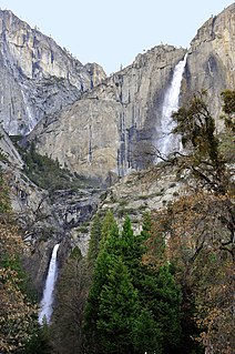
Yosemite Falls is the highest waterfall in Yosemite National Park, dropping a total of 2,425 feet (739 m) from the top of the upper fall to the base of the lower fall. Located in the Sierra Nevada of California, it is a major attraction in the park, especially in late spring when the water flow is at its peak.

Multnomah Falls is a waterfall located in the Columbia River Gorge, east of Troutdale, between Corbett and Dodson, Oregon, United States. The waterfall is accessible from the Historic Columbia River Highway and Interstate 84. Spanning two tiers on basalt cliffs, it is the tallest waterfall in the state of Oregon at 620 ft (189 m) in height.

McArthur–Burney Falls Memorial State Park is the second oldest state park in the California State Parks system, located approximately 6 miles (9.7 km) north of Burney, California. The park offers camping, fishing, watersports, hiking and horseback riding facilities. The park is mainly known for the waterfall, Burney Falls, at the entrance of the park. Wildlife in the park includes bass, trout, Steller's jay, squirrels, woodpeckers, deer, and on rare occasion, black bear.

The McKenzie River is a 90-mile (145 km) tributary of the Willamette River in western Oregon in the United States. It drains part of the Cascade Range east of Eugene and flows westward into the southernmost end of the Willamette Valley. It is named for Donald McKenzie, a Scottish Canadian fur trader who explored parts of the Pacific Northwest for the Pacific Fur Company in the early 19th century. As of the 21st century, six large dams have been built on the McKenzie and its tributaries.

The McCloud River is a 77.1-mile (124.1 km) long river that flows east of and parallel to the upper Sacramento River, in Siskiyou County and Shasta County in northern California in the United States. It drains a scenic mountainous area of the Cascade Range, including part of Mount Shasta. It is a tributary of the Pit River, which in turn flows into the Sacramento River. The three rivers join in Shasta Lake, formed by Shasta Dam north of Redding.

The Mundo is a river in south-eastern Spain. It originates slightly south of Riópar in the mountain plateau Calar del Mundo. From there it flows towards Riopar and then westwards until it joins the Segura south of Hellín.

Wapama Falls is the larger of two waterfalls located on the northern wall of Hetch Hetchy Valley in Yosemite National Park. It flows almost year-round and during peak flow has been known to inundate the trail bridge crossing its base, making the falls impossible to pass. The falls consist of two primary drops angled roughly 60 degrees to each other, and a broad cascade at its base. Wapama Falls is fed by Lake Vernon, a few miles to the north.

The River Doe is a river in North Yorkshire, England. The river's source is near God's Bridge close to the settlement of Chapel-le-Dale and flows through Twisleton in a south-westerly direction to Ingleton, where it meets the River Twiss to form the River Greta. The river forms part of the River Lune system that flows into the Irish Sea.
Linville Falls is a waterfall located in the Blue Ridge Mountains of North Carolina in the United States. The falls move in several distinct steps, beginning in a twin set of upper falls, moving down a small gorge, and culminating in a high-volume 45-foot (14 m) drop. It is named for the Linville River, which goes over the falls. Linville Falls has the highest volume of any waterfall on the Northern Edge of the Blue Ridge Mountains.

Siruvani Waterfalls and the dam named after them are located 36 km (22 mi) west of Coimbatore in the Western Ghats. The reservoir at Siruvani was built for Tamil Nadu by the Kerala government with funds collected by the Tamil Nadu government to meet the drinking water requirements of Coimbatore. The gateways on either side of the road across the dam are typical of the Kerala and Tamil architectural styles. Siruvani is also home to certain tribals like the Mudugars and Irulars. Water from Siruvani River is renowned for its taste and mineral properties, and the view from the falls and the dam is a tourist attraction.

Cascade Falls, also called "The Cascades", is a waterfall located at E. B. Jeffress Park on the Blue Ridge Parkway in the Blue Ridge Mountains of North Carolina, United States.

Bonita Falls are a set of waterfalls in the San Bernardino National Forest, formed by Bonita Creek, that is said to be 370 or 400 feet in height, but possibly up to 495 feet high because of two undocumented drops in the canyon above. It is the second tallest in the national forest, being surpassed only by 500-foot Big Falls. These two waterfalls are reputably the tallest in southern California.

Lower Kama Reservoir or Nizhnekamsk Reservoir is the lowest reservoir from the Kama River hydroelectric cascade. It is situated in Tatarstan, Udmurtia, Bashkortostan and Perm Krai, Russian Federation. The reservoir was filled in 1978-81 up to 62 m above sea level after the construction of dam of the Lower Kama Hydroelectric Station. The water level in reservoir depends on the upper reservoirs regime. The Lower Kama Reservoir has a surface area of 1,084 km² and a volume of 2.8 billion cubic meters. Its length along Kama is 185 km and 157 km along Belaya. The reservoir also used for water supply, irrigation and fishing.
The Paradise River is known for having a total of 8 major waterfalls.
The Pywiack Cascade is a waterfall in Yosemite National Park within the U.S. state of California. It is located a few miles downstream from the outlet of Tenaya Lake on Tenaya Creek at the head of the steep and rugged granite gorge, Tenaya Canyon. The waterfall can be viewed from Glacier Point, or by a 6-mile (9.7 km) hike from Olmsted Point, but the canyon is dangerous and the waterfall is unsafe to be reached on foot. The waterfall is highly seasonal. It typically rages in the spring and early summer while shrinking to a trickle by late summer to mid-autumn.
The Kelbra Dam is a dam on the River Helme in the German state of Saxony-Anhalt. Behind the dam is the lake known as the Kelbra Reservoir or Kelbra Flood Retention Basin.
The Rödelbachgraben, usually called the Rödelbach and also incorrectly referred to as the Rieschengraben, is a river which was altered for mining purposes. It is the oldest fully functioning part of the Lower Harz Pond and Ditch System in the Harz Mountains of Germany. The ditch was first mentioned in the records as the Oberer Rödelbachgraben in the year 1610.
Upper Chush Falls is a 200-foot (61 m) waterfall on Whychus Creek, in the Cascade Range southwest of Sisters in the U.S. state of Oregon. Chush Falls, a 50-foot (15 m) waterfall, is further downstream on the same creek. Lying between Chush and Upper Chush is a third waterfall, The Cascade. These and several other falls on tributaries in the vicinity are within the Three Sisters Wilderness. The Northwest Waterfall Survey lists the fall's average flow at 40 cubic feet per second (1.1 m3/s). The highest flows occur between May and August.


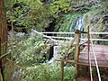 Footbridge and lever for operating the retention system
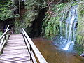 Upper fall and water reservoir
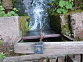 View from above of the closed slider
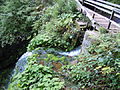 Dam facility and edge of the lower main waterfall


