
The Northern Black Forest (German : Nordschwarzwald) refers to the northern third of the Black Forest in Germany or, less commonly today, to the northern half of this mountain region.
The Northern Black Forest (German : Nordschwarzwald) refers to the northern third of the Black Forest in Germany or, less commonly today, to the northern half of this mountain region.
The Northern Black Forest is bounded in the north by a line from Karlsruhe to Pforzheim and, in the south, by a line running from the Rench valley to Freudenstadt. Its northern boundary largely coincides with the emergence of the extensively forested bunter sandstone strata from the arable region of the Kraichgau; its southern boundary with the Central Black Forest (or, in the case of a bipartite division, the Southern Black Forest) varies depending on the definition or natural regional division used (see also Black Forest). Earlier, the Northern Black Forest was the entire northern half of the mountain range as far as the line of the Kinzig valley, which divides the Black Forest east of Lahr. To the west it is bounded by the Upper Rhine Plain, to the east by the Gäu landscapes.
The Northern Black Forest is not the same as the spatial-planning region of Northern Black Forest, which covers the eastern area.
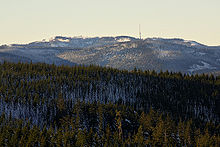
With its rather angular – in places trapezoidally-shaped – summits, the Northern Black Forest rises above the Rhine Plain by more than 1,000 m. By contrast, its eastern slopes descend gradually and there is less of a height difference with its neighbouring regions. Its highest peak is the Hornisgrinde at 1,163 m above sea level (NHN) . Woods cover on average 73% of the whole land area and make the Northern Black Forest the most cohesive forested part of the Black Forest, but there are also extensive areas of so-called "Grinden": treeless, wet heaths, on its highland slopes.
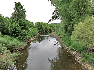
Geologically, the dominant rock of the Northern Black Forest is bunter sandstone, although in the deeply incised west its gneiss bedrock reaches the surface. Granites (e.g. Forbach granite) and porphyries have intruded forming crags and tors. The highland regions of the Northern Black Forest are among the regions of the German Central Uplands with the heaviest rainfall (up to 2,200 mm per annum). Its most important rivers are the Murg, Nagold, Enz, Alb, Acher, Rench, Oos and the upper reaches of the Wolf.
In 2001, the Central and Northern Black Forest Nature Park (Naturpark Schwarzwald Mitte/Nord) was established and its coverage includes the whole of the Northern Black Forest. In addition, an area of about 10,000 hectares has been designated since 1 January 2014 as the Black Forest National Park. It has numerous highly popular tourist attractions as well as winter sport areas in addition to the towns named below and the Black Forest High Road and Kaltenbronn.


Numerous tarns in the Northern Black Forest are evidence of ice age glacial formations, The best-known is the Mummelsee on the Hornisgrinde. Other tarns are the Ellbachsee, Herrenwieser See, Huzenbacher See, Sankenbachsee, Schurmsee and the Wildsee near Ruhestein. Many of them were also impounded in order to supply excess water for timber rafting which was common until the 19th century. Other former tarns have silted up.
The Hohlohsee and the Wildsee near Gernsbach-Kaltenbronn are raised bog lakes on the highlands between the Murg and Enz valleys that are only fed by local precipitation.
There are several dams in the Northern Black Forest. The Schwarzenbach Dam and the Murg Dam are part of the Rudolf-Fettweis-Werk, a pumped storage and run-of-the-river power station in Forbach. The Nagold Dam regulates the water level of the Nagold. The Kleine Kinzig Dam is used for drinking water, water regulation and electricity generation.

Due to the vast preserved natural scenery, the region is popular among hikers.
In the winter time, the Northern Black Forest region attracts tourists with the ski resorts Mehliskopf, Hundseck – Bühlertallifte, Kaltenbronn, Simmersfeld. [4]

The Black Forest is a large forested mountain range in the state of Baden-Württemberg in southwest Germany, bounded by the Rhine Valley to the west and south and close to the borders with France and Switzerland. It is the source of the Danube and Neckar rivers.

The Murg is an 80.2-kilometre-long river and a right tributary of the Rhine in Baden-Württemberg, Germany. It flows through the Northern Black Forest into the Upper Rhine Plain, crossing the counties of Freudenstadt and Rastatt.
The Enz is a river flowing north from the Black Forest to the Neckar in Baden-Württemberg. It is 106 km long.

The Wildsee is a small lake within an area of bog between Bad Wildbad and Gernsbach, high in the Northern Black Forest mountain range in southwestern Germany. The lake is fed by rain water. It is part of the Kaltenbronn Nature Reserve.

The Acher is a 53.6-kilometre-long river and right-hand tributary of the Rhine in the county of Ortenau, in the south German state of Baden-Württemberg. It flows in an northwesterly direction from the Black Forest to the Rhine, between the two rivers Rench to the south and the Oos to the north.
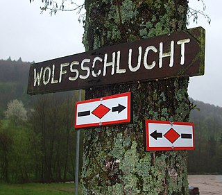
The Westweg is a long-distance hiking trail in Germany, running north–south through the Black Forest from Pforzheim to Basel. The trail is around 285 km long, and was founded in 1900. It is currently maintained under the auspices of the Black Forest Club. The trail symbol is a red lozenge on a white background. The Westweg is a part of the European Long-distance Trail E1 The route passes through or near numerous villages or small towns, so there is no difficulty in finding overnight accommodation and meals along the route. It would actually require more planning to walk it while staying in youth hostel-type accommodation, or camping. There are a number of services that will transport your luggage to the next accommodation by vehicle, leaving the hikers with only their daypacks for the hike. The route can be accessed at several places along its length by road or public transport, so it is easy to walk part of it or to do day walks along its route.

The Mummelsee is a 17-metre-deep lake at the western mountainside of the Hornisgrinde in the Northern Black Forest of Germany. It is very popular with tourists travelling along the Black Forest High Road. According to legends, the lake is inhabited by a Nix and the King of the Mummelsee.
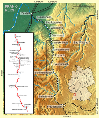
The Murg Valley Railway is a 58 kilometre long railway line in the Northern Black Forest in Germany, that links Rastatt and Freudenstadt. It was opened in stages from 1868 to 1928 being built outwards from both Rastatt and Freudenstadt. The route through the narrow Murg Valley required the construction of numerous tunnels and bridges. The section between the stations of Baiersbronn and Freudenstadt Stadt is a steep ramp which is why it had to be operated until 1926 as a rack railway. Even today it can only be worked by vehicles that have the required approval.

The Seekopf is a mountain on the main chain of the Northern Black Forest in Germany between the Upper Rhine Plain and the Murg valley, above Seebach. It is 1,054.2 m above sea level (NHN) and lies on the boundary of the counties of Ortenaukreis and Freudenstadt in the state of Baden-Württemberg.

The Eutingen im Gäu–Schiltach railway line is a railway line in the German state of Baden-Württemberg that runs from the cultural landscape of the Gäu to the eastern edge of the Black Forest, connecting Eutingen and Schiltach via Freudenstadt. It is a section of the Gäu Railway from Stuttgart to Freudenstadt opened on 1 September 1879.

The Black Forest National Park is a national park in the state of Baden-Württemberg in the southwest of Germany.

The Central Black Forest, also called the Middle Black Forest, is a natural or cultural division of the Black Forest in Baden-Württemberg in Germany. It generally refers to a region of deeply incised valleys from the Rench valley and southern foothills of the Kniebis in the north to the area of Freiburg im Breisgau and Donaueschingen in the south. Its highest area, which is southeast of the Elz valley, is also part of the High Black Forest.

The Central/North Black Forest Nature Park is located in Baden-Württemberg in Germany. It covers an area of 3,750 km2 and was founded in December 2000. As of 2018, it is the third-largest nature park in Germany.

The Schwarzenbach Dam is a gravity dam near Forbach in the Northern Black Forest of Germany. It is the most important structure of the Rudolf-Fettweis-Werk's pumped storage power station. The operator of the dam, which was completed in 1926 in a side valley of the Murg valley, is EnBW Kraftwerke.

The Hoher Ochsenkopf is a mountain in the Northern Black Forest in the municipality of Forbach in south Germany. At 1,054.5 m above sea level (NHN) it is the highest point in Forbach and also in the county of Rastatt. The mountain, whose domed summit or kuppe was already a nature reserve lies in the Black Forest National Park which was founded in 2014. Its name recalls its former use as wood pasture.

The Hohloh is a mountain, 988.3 m above sea level (NHN), on the eastern main ridge of the Northern Black Forest in Germany. It lies near the village of Kaltenbronn in the borough of Gernsbach, a town in the county of Rastatt in the German state of Baden-Württemberg. Its summit is the highest point in the borough of Gernsbach and the eastern chain of the Northern Black Forest, the ridge between the rivers Murg and Enz. A mountain pass runs northeast of the summit plateau between the two river valleys passing over the saddle of Schwarzmiss.
The Gäu Perimeter Way is a hiking trail in the Northern Black Forest in Germany and the easternmost of the long distance paths managed by the Black Forest Club. With a length of 120 kilometres, it runs in six stages from Mühlacker to Freudenstadt.

The Rench Valley Trail is a 98-kilometre-long 'prestige hiking trail (Prädikatswanderweg) in the Central/North Black Forest Nature Park in Germany. It runs in five stages around the Rench valley with its start and finish near Oberkirch.
The Kunstpfad am Mummelsee is a sculpture path around the Mummelsee, which is located in the municipality of Seebach near Achern in the northern Black Forest in Baden-Württemberg (Germany). The sculpture path is 0,8 kilometres long is primarily used for nature and art walks.