Hoher Ochsenkopf

Last updated
Hoher Ochsenkopf

HoherOchsenkopf.jpg

The Bannwald and remains of the blown up viewing tower on the summit of the Hoher Ochsenkopf
Highest point
Elevation 1,054.5 m above  sea level (NHN) (3,460 ft)
Coordinates 48°38′36″N8°16′08″E / 48.64333°N 8.26889°E / 48.64333; 8.26889 Coordinates: 48°38′36″N8°16′08″E / 48.64333°N 8.26889°E / 48.64333; 8.26889
Geography
Baden-Wuerttemberg relief location map.jpg
Red triangle with thick white border.svg
Hoher Ochsenkopf
Parent range Black Forest
Geology
Type of rock Bunter Sandstone
View from Hohloh of the Hornisgrinde. The Hoher Ochsenkopf is the sunlit kuppe in the right half of the picture; its summit is just below the Hornisgrinde transmission tower. Hornisgrinde-from-Hohloh-IMGP0125.jpg
View from Hohloh of the Hornisgrinde. The Hoher Ochsenkopf is the sunlit kuppe in the right half of the picture; its summit is just below the Hornisgrinde transmission tower.

The Hoher Ochsenkopf ("High Ochsenkopf", literally "High Oxen Peak") is a mountain in the Northern Black Forest in the municipality of Forbach in south Germany. At 1,054.5 m above  sea level (NHN) [1] it is the highest point in Forbach and also in the county of Rastatt. The mountain, whose domed summit or kuppe was already a nature reserve lies in the Black Forest National Park which was founded in 2014. [2] Its name (which means "high oxen-peak") recalls its former use as wood pasture. [3]

Northern Black Forest German forest

The Northern Black Forest refers to the northern third of the Black Forest in Germany or, less commonly today, to the northern half of this mountain region.

Forbach (Baden) Place in Baden-Württemberg, Germany

Forbach is a village in Baden-Württemberg, Germany. It lies in the district of Rastatt. It is located in the Murg river valley, in the northern part of the Black Forest mountains. Forbach is further broken down into the following districts: Langenbrand, Bermersbach, Gausbach, Hundsbach, Herrenwies, Kirschbaumwasen, Erbersbronn, Raumünzach and Schwarzenbach.

<i>Normalhöhennull</i> standard reference level, the equivalent of sea level, used in Germany to measure height

Normalhöhennull or NHN is a vertical datum used in Germany.

Contents

Location

The Hoher Ochsenkopf lies about six kilometres northeast of the highest mountain in the Northern Black Forest, the Hornisgrinde, which is 108 metres higher. Like the Badener Höhe three kilometres north it is part of an eastern spur of the main chain of the northern Black Forest, which runs between the Upper Rhine Plain and the Murg valley. This spur is bounded by two western side valleys of the Murg, the valley of the Hundsbach with the Forbach village of Hundsbach in the south and the Schwarzenbach valley with the village of Herrenwies in the north and the Schwarzenbach Dam in the northeast. The Hoher Ochsenkopf is linked to the Mittlerer Ochsenkopf ("middle oxen-peak", 1,004.9 m) to the south over the Kegelplatz, a 977-metre-high saddle. The 964-metre-high Vorderer Ochsenkopf ("anterior oxen-peak") adjoins the Mittlerer Ochsenkopf to the south and, further east, is the Nägeliskopf (994 m). In the northwest, the 948-metre-high saddle of Dreikohlplatten links the Hoher Ochsenkopf to the Mehliskopf (1008 m).

Hornisgrinde mountain

The Hornisgrinde, 1,164 m (3,820 ft), is the highest mountain in the Northern Black Forest of Germany. The Hornisgrinde lies in northern Ortenaukreis district.

Badener Höhe mountain

The Badener Höhe is a mountain in the Northern Black Forest in the German state of Baden-Württemberg. It lies within the borough of Baden-Baden and municipality of Forbach. With a height of 1,002.5 m above sea level (NHN), it is the highest point in the borough of Baden-Baden.

Black Forest mountain range in Baden-Württemberg, southwestern Germany

The Black Forest is a large forested mountain range in the state of Baden-Württemberg in southwest Germany. It is bounded by the Rhine valley to the west and south. Its highest peak is the Feldberg with an elevation of 1,493 metres (4,898 ft). The region is roughly oblong in shape with a length of 160 km (99 mi) and breadth of up to 50 km (31 mi).

Hoher Ochsenkopf Nature Reserve

The flat and once deforested domed summit or kuppe , then a typical grinde of the Northern Black Forest, was used in past centuries as pasture. The forest recolonised the area after grazing ended. In 1970 a Bannwald forest, 41.1 hectares in area, was declared around the summit and, in 1975, it was turned into a nature reserve. In 1986, in order to protect the capercaillie, a bird reserve, 600 ha in area, was declared around the Hoher Ochsenkopf. In 2000 the Bannwald was extended to an area of 100.7 ha and complemented by the surrounding, 427 ha of Schonwald , a form of semi-protected forest, called the Nägeliskopf. [4]

<i>Kuppe</i> hilltop

A Kuppe is the term used in German-speaking central Europe for a mountain or hill with a rounded summit that has no rock formation, such as a tor, on it. A range of such hills is called a Kuppengebirge. In geology the term also refers to corresponding stratigraphic forms. The term is similar to the English topographical and geological terms, knoll and dome. It is similar to the French word ballon which means a mountain with a rounded summit.

Grinde (landform)

A grinde is an almost treeless area of wet heathland found on the rounded bunter sandstone ridges of the Northern Black Forest in Germany. The grinden reached their greatest extent in the early 19th century when they ran from the Kniebis mountain near Freudenstadt in the south to the heights near Dobel in the north. Today they are restricted to the highest parts of the Northern Black Forest around the summits of the Hornisgrinde, Schliffkopf and Kniebis. They still cover an area of about 180 ha. Conservation measures and careful grazing by robust breeds of cattle, goats and sheep should enable the remaining grinden to be preserved for their great ecological value and as an important feature of the landscape. Most of them are under conservation orders.

Pasture land used for grazing

Pasture is land used for grazing. Pasture lands in the narrow sense are enclosed tracts of farmland, grazed by domesticated livestock, such as horses, cattle, sheep, or swine. The vegetation of tended pasture, forage, consists mainly of grasses, with an interspersion of legumes and other forbs. Pasture is typically grazed throughout the summer, in contrast to meadow which is ungrazed or used for grazing only after being mown to make hay for animal fodder. Pasture in a wider sense additionally includes rangelands, other unenclosed pastoral systems, and land types used by wild animals for grazing or browsing.

Numerous rare and endangered animal and plant species have settled here, including the three-toed woodpecker, which had been extinct for many years in the Black Forest.

Eurasian three-toed woodpecker species of bird

The three-toed woodpecker is a medium-sized woodpecker.

Development

The Teufelskamin ("Devil's Chimney") on the Hoher Ochsenkopf Teufelskamin.jpg
The Teufelskamin ("Devil's Chimney") on the Hoher Ochsenkopf

The Hoher Ochsenkopf is accessible on foot from Hundseck on the Black Forest High Road over a roughly three-kilometre-long ridgeway or after a steep climb from Herrenwies or Hundsbach-Aschenplatz/Bridge along the Kirchweg.

The start point is the östlichen Dreikohlplatten. From there a path marked by blue and white wooden posts leads initially gently uphill. Later it becomes unmarked and climbs steeply uphill to the point, where there used to be a seven-metre-high observation tower, built in 1902, that was replaced in 1927 by a 12-metre-high stone tower. After a lightning strike, it was blown up by the Technisches Hilfswerk in 1971. Even today the rubble pile of stone blocks is still visible. The path continues uphill towards the Teufelskamin ("Devil's Chimney"), an open fault in the Bunter sandstone that appears as a 20-metre-deep cave.

<i>Technisches Hilfswerk</i> Civil protection organization

The Bundesanstalt Technisches Hilfswerk is a civil protection organisation controlled by the German federal government. 99% of its 79,514 members (2016) are volunteers.

In geology, a fault is a planar fracture or discontinuity in a volume of rock, across which there has been significant displacement as a result of rock-mass movement. Large faults within the Earth's crust result from the action of plate tectonic forces, with the largest forming the boundaries between the plates, such as subduction zones or transform faults. Energy release associated with rapid movement on active faults is the cause of most earthquakes.

Around the Hoher Ochsenkopf runs the almost level Becker Way (Beckerweg), a circular walk re-established by the Black Forest Club branches of Hornisgrinde, Achern, Bühl and Baden-Baden in 2003. The path is named after Daniel Becker from Frankfurt, who stayed in the old Kurhaus at Hundseck more than 100 years ago and explored the region around the Hoher Ochsenkopf.

Related Research Articles

Murg (Northern Black Forest) river and right tributary of the Upper Rhine in Baden-Württemberg, Germany

The Murg is an 80.2-kilometre-long river and a right tributary of the Rhine in Baden-Württemberg, Germany. It flows through the Northern Black Forest into the Upper Rhine Plain, crossing the counties of Freudenstadt and Rastatt.

Wildsee (Kaltenbronn) lake

The Wildsee is a small lake within an area of bog between Bad Wildbad and Gernsbach, high in the Northern Black Forest mountain range in southwestern Germany. The lake is fed by rain water. It is part of the Kaltenbronn Nature Reserve.

Schwarzwaldhochstraße street in Baden-Baden, Germany

The Schwarzwaldhochstraße, or "Black Forest High Road", is the oldest, and one of the best known, themed drives in Germany. It is a part of the B 500 federal highway.

Belchen (Black Forest) Mountain in the Black Forest, Germany

The Belchen, 1,414 metres (4,639 ft), or Black Forest Belchen is the fourth highest summit of the Black Forest after the Feldberg, Seebuck and the Herzogenhorn. The municipalities of Münstertal, Schönenberg and Kleines Wiesental meet on the summit dome of the Belchen which is located in the southwest German state of Baden-Württemberg.

Seekopf (Seebach) mountain

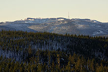
The Seekopf is a mountain on the main chain of the Northern Black Forest in Germany between the Upper Rhine Plain and the Murg valley, above Seebach. It is 1,054.2 m above sea level (NHN) and lies on the boundary of the counties of Ortenaukreis and Freudenstadt in the state of Baden-Württemberg.

Wild Gutach river in Germany

The Wild Gutach is a river in Baden-Württemberg, Germany. It flows into the Elz in Gutach im Breisgau.

Black Forest National Park national park in Baden-Württemberg, Germany

The Black Forest National Park was created on 1 January 2014 and is the first national park in Baden-Württemberg, Germany. The state parliament voted for its establishment on 28 November 2013. The national park has an area of 10,062 hectares and is located on the main crest of the Northern Black Forest, mainly between the Black Forest High Road (Schwarzwaldhochstraße) and the valley of the Murg. It comprises two separate areas, roughly 3.5 kilometres apart, around Ruhestein and Hoher Ochsenkopf/Plättig and is part of the Central/North Black Forest Nature Park. The park was officially opened on 3 May 2014

Schwarzenbach Dam dam

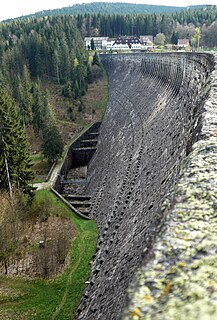
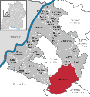
The Schwarzenbach Dam is a gravity dam near Forbach in the Northern Black Forest of Germany. It is the most important structure of the Rudolf-Fettweis-Werk's pumped storage power station. The operator of the dam, which was completed in 1926 in a side valley of the Murg valley, is EnBW Kraftwerke.

Mehliskopf mountain in the Black Forest, Germany

The Mehliskopf is a mountain, 1,007.8 m above sea level (NHN), on the main chain of the Northern Black Forest in Germany. It lies above the Black Forest High Road, between Sand and Hundseck. On the north flank of the mountain there is ski piste with lifts and an all-year-round bobsleigh run. Nearby is a climbing garden and an adventure playground.

Seekopf is German for “lake head” or “lake peak” and may refer to the following mountains:

Hohloh mountain

The Hohloh is a mountain, 988.3 m above sea level (NHN), on the eastern main ridge of the Northern Black Forest in Germany. It lies near the village of Kaltenbronn in the borough of Gernsbach, a town in the county of Rastatt in the German state of Baden-Württemberg. Its summit is the highest point in the borough of Gernsbach and the eastern chain of the Northern Black Forest, the ridge between the rivers Murg and Enz. A mountain pass runs northeast of the summit plateau between the two river valleys passing over the saddle of Schwarzmiss.

Bernstein (Northern Black Forest) mountain

The Bernstein is a mountain, 693.5 m above sea level (NHN), in the Northern Black Forest within the borough of Gaggenau, and the borough of Bad Herrenalb,. It is part of the ridge that borders the lower Murg valley on its eastern side. The summit of this mountain is formed by a six-metre-high crag made of bunter sandstone with a flat top, 25 m² in area, from where there are good views.

The Herrenwieser See is a tarn in the municipality of Forbach in the Northern Black Forest in Germany. It lies at a height of 830 metres, a little northwest of the Schwarzenbach Reservoir and 1,600 metres as the crow flies northeast of Herrenwies on the eastern mountainside of the 1,001-metre-high Seekopf, a subpeak of the Badener Höhe. The lake covers an area of 1.2 hectares and is up to 9.5 metres deep. Habitats Directive area and, together with the cirque headwall, designated as a biotope. It can be circumnavigated on a footpath. The lake itself is surrounded by a fence and the shore is out-of-bounds for nature conservation reasons.

Herrenwieser Schwallung reservoir

The Herrenwieser Schwallung is a splash dam, built in 1844–47 of bunter sandstone, near Herrenwies in the Black Forest, which impounds the waters of the Schwarzenbach stream into a pond. In the days of timber rafting it was periodically opened and washed the fallen logs or timber rafts downstream into the valley. Today the dam acts as a bridge over the Schwarzenbach.

References

  1. Map services of the Federal Agency for Nature Conservation
  2. Bonde: Nationalpark in den Gebieten Ruhestein und Ochsenkopf. In: Stuttgarter Zeitung online dated 4 June 2013
  3. Rudolf Metz: Mineralogisch-landeskundliche Wanderungen im Nordschwarzwald, besonders in dessen alten Bergbaurevieren. 2nd, fully revised edition, Schauenburg, Lahr, 1977, ISBN   3-7946-0128-9, p. 79.
  4. Fact file of the Nature Reserve in the index of protected areas published by the Baden-Württemberg Office for the Environment, Survey and Conservation (Landesanstalt für Umwelt, Messungen und Naturschutz Baden-Württemberg)

Literature