Mummelsee

Last updated
Mummelsee
Mummelsee01.jpg
Baden-Wuerttemberg relief location map.jpg
Red pog.svg
Mummelsee
Location Black Forest
Coordinates 48°35′53″N8°12′3″E / 48.59806°N 8.20083°E / 48.59806; 8.20083 Coordinates: 48°35′53″N8°12′3″E / 48.59806°N 8.20083°E / 48.59806; 8.20083
Basin  countriesGermany
Max. depth17 metres (56 ft)
Surface elevation1,036 metres (3,399 ft)

The Mummelsee is a 17-metre-deep lake at the western mountainside of the Hornisgrinde in the Northern Black Forest of Germany. It is very popular with tourists travelling along the Black Forest High Road. According to legends, the lake is inhabited by a Nix and the King of the Mummelsee. [1]

Contents

With a circumference of 800 meters, the Mummelsee is the largest of the seven cirque lakes in the Black Forest, the deepest at 17 m deep and the highest at 1036 m. [2]

Geography

The Mummelsee has a circumference of approximately 800 m (2,625 ft) and is surrounded by steep and forested mountain slopes on its northern, western and eastern sides. The western lakeside rises towards the mountain "Katzenkopf" (1,123 m (3,684 ft) above sea level), and the northern lakeshore rises towards Hornisgrinde. With 1,163 m (3,816 ft) above sea level, Hornisgrinde is the highest mountain in the Northern Black Forest. Solely the southern lake banks are (nearly) flat. This also being the place where the alpine hotel "Mummelsee" and the close-by St. Michaels chapel are located.

Etymology

According to statements made by the town Seebach, the name of the Mummelsee derives from the (German) vernacular term "Mummeln" used for white waterlilies (Nymphaea alba). [3] In the past, this species of plant could be found in large numbers in that area. The yellow pond lily, Nuphar lutea, is also called "Mummel." The myth of the nix, which were called "Mümmlein" (diminutive form of "Mummel"), possibly could have been the namesake of the lake as well. [4] [5]

Connected to this context, the white waterlily is also referred to as "Nixblume" meaning "nix flower". [6]

Tourism

The Chapel of St Michael at the Mummelsee St. Michael (Mummelsee) jm53161.jpg
The Chapel of St Michael at the Mummelsee

Favoured by the route of the Schwarzwaldhochstraße, the lake became a tourist destination. A bigger building that includes the hotel, two restaurants, one grocery and souvenir store, as well as a paddleboat rental is located directly near the visitors' car park. [7] [8]

A great part of the hotel building burnt down on 5 May 2008. [9] The fire was presumably a case of arson. [10] After the incident, the hotel was rebuilt in the "Schwarzwaldstil" with an increase of usable floor space from 2,385 m2 (25,672 ft2) to 3,690 m2 (39,719 ft2) and reopened on 26 March 2010.

The Chapel of St Michael was inaugurated in 1937. It was dedicated to the Archangel Michael, an impressive reminder at a time when the National Socialists were gaining more power. From the outside, the low roof of the chapel is striking. It is modeled on a Black Forest house. The slim tower stylises a Black Forest fir. [11]

Trails

Formerly, the naturally existing trail around the lake was kept in its original state with several tight passages and obstructive tree roots.

In 1999, the Kunstpfad am Mummelsee , a sculpture path by international artists was installed along the circular trail. It presents 18 installations of artists visualising the connection of nature, landscape and art. [12] [13]

In 2014, the path was reconstructed barrier-free. [14]

The long-distance hiking trail with the red diamond (Westweg from Pforzheim to Basel) passes here as well as the other regional routes (blue and yellow diamond) and circular hiking trails. It is only a short trip up to the Hornisgrinde (1.5 km and 120 meters in altitude). [15]

Other trails are:

Transportation

Visitors' parking spaces are located at the southern lake shore. Busses for hiking tourists drive to Baden-Baden, Achern and Freudenstadt on a daily basis. On weekends, there are direct bus connections available to Oppenau and once on Saturday and Sunday each to Offenburg. The "Baden-Württemberg-Ticket", "Schönes-Wochenende-Ticket" and the "Konus-Ticket" (sold by the Deutsche Bahn and local bus companies) are valid to use on all these routes.

The Mummelsee in literature

See also

Related Research Articles

<span class="mw-page-title-main">Black Forest</span> Mountain range in Germany

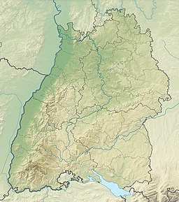
The Black Forest is a large forested mountain range in the state of Baden-Württemberg in southwest Germany, bounded by the Rhine Valley to the west and south and close to the borders with France and Switzerland. It is the source of the Danube and Neckar rivers.

<span class="mw-page-title-main">Freiburg im Breisgau</span> City in Baden-Württemberg, Germany

Freiburg im Breisgau, commonly referred to as Freiburg, is an independent city in Baden-Württemberg, Germany. With a population of about 230,000, Freiburg is the fourth-largest city in Baden-Württemberg after Stuttgart, Mannheim, and Karlsruhe. The Freiburg built-up area had a population of 354,500 (2021). The population of the greater Freiburg metropolitan area ("Einzugsgebiet") was 656,753 in 2018. In the south-west of the country, it straddles the Dreisam river, at the foot of the Schlossberg.

<span class="mw-page-title-main">Seewald</span> Municipality in Baden-Württemberg, Germany

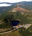
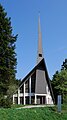
Seewald is a municipality in the Freudenstadt district in Baden-Württemberg in southern Germany. It lies in the Black Forest. The source of the river Nagold is situated in the municipality. There is a dam in the river near the village Erzgrube, forming the artificial lake Nagoldsee. Erzgrube lies 550 m (1,804 ft) above sea level. Other subdivisions lie between 750 and 850 m above sea level in the midst of the forests. 90% of the area is covered with forests.

<span class="mw-page-title-main">Achern</span> Town in Baden-Württemberg, Germany

Achern is a town in Western Baden-Württemberg, Germany. It is located approximately 18 km southwest of Baden-Baden and 19 km northeast of Offenburg. Achern is the fourth largest town in the district of Ortenau (Ortenaukreis), after Offenburg, Lahr / Black Forest and Kehl.

<span class="mw-page-title-main">Schluchsee</span> Dam in Breisgau-Hochschwarzwald

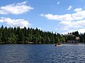
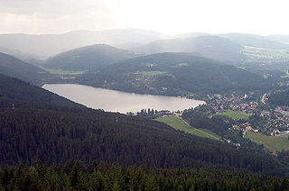
The Schluchsee is a reservoir lake in the district of Breisgau-Hochschwarzwald, southeast of the Titisee in the Black Forest near Freiburg im Breisgau, Germany.

<span class="mw-page-title-main">Schauinsland</span> Mountain in the Black Forest, Germany

The Schauinsland is a mountain in the Black Forest with an elevation of 1,284 m (4,213 ft) above sea level. It is a popular destination for day trips. Due to the high amount of silver mining, it was previously known as "Erzkasten" ; the name "Schouwesland" first appeared in 1347. The mountain is located roughly ten kilometres south-east of Freiburg's city centre.

<span class="mw-page-title-main">Acher</span> River in Germany

The Acher is a 53.6-kilometre-long river and right-hand tributary of the Rhine in the county of Ortenau, in the south German state of Baden-Württemberg. It flows in an northwesterly direction from the Black Forest to the Rhine, between the two rivers Rench to the south and the Oos to the north.

<span class="mw-page-title-main">Titisee-Neustadt</span> Town in Baden-Württemberg, Germany

Titisee-Neustadt is a municipality in the district of Breisgau-Hochschwarzwald in Baden-Württemberg in southern Germany. It is made up of the six communities of Neustadt, Langenordnach, Rudenberg, Titisee, Schwärzenbach and Waldau.

<span class="mw-page-title-main">Hinterzarten</span> Municipality in Baden-Württemberg, Germany

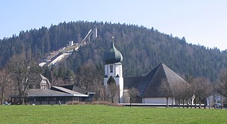
Hinterzarten is a resort village in the Black Forest, located in the southwest of the state of Baden-Württemberg, Germany. Although Hinterzarten is mostly famous for its ski jumping, it has many other tourist attractions.

<span class="mw-page-title-main">Dietingen</span> Municipality in Baden-Württemberg, Germany

Dietingen is a municipality in the district of Rottweil, in Baden-Württemberg, Germany.

<span class="mw-page-title-main">Stegen</span> Municipality in Baden-Württemberg, Germany

Stegen is a municipality in the Breisgau-Hochschwarzwald district, Baden-Württemberg, Germany. It borders on the city of Freiburg, being about 8 km away as the crow flies, lying in the valley of the river Dreisam. The municipality includes three population centres: the town of Stegen and the villages of Eschbach and Wittental.

<span class="mw-page-title-main">Schwarzwaldverein</span> Voluntary association

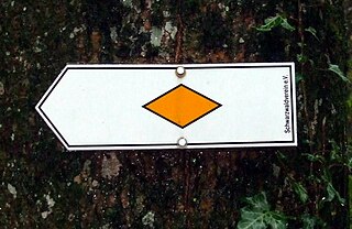
The Schwarzwaldverein was founded in Freiburg im Breisgau (Germany) in 1864, making it the oldest German hiking and mountaineering club. The Schwarzwaldverein has almost 90,000 members in 241 local chapters. Activities of the club include hiking, environmental protection, the promotion of local culture, trail maintenance, and family and youth work projects in the Black Forest.

<span class="mw-page-title-main">Schwarzwaldhochstraße</span>

The Schwarzwaldhochstraße or Black Forest High Road is the oldest and one of the best known themed drives in Germany. It is a part of the B 500 federal highway and leads over 60 km from Baden-Baden to Freudenstadt.

<span class="mw-page-title-main">Northern Black Forest</span>

The Northern Black Forest refers to the northern third of the Black Forest in Germany or, less commonly today, to the northern half of this mountain region.

<span class="mw-page-title-main">Falkenfelsen</span> Rock formation in Germany

The Falkenfelsen(Falcon Rock) is a granite rock formation in the Northern Black Forest of Germany's Baden-Württemberg state. One side of the formation is a cliff about 200 feet (61 m) high. From the Schwarzwaldhochstrasse (Black Forest Highway), two hiking trails lead through the formation and end at the shelter Herta-hut. The platform has a view over the northern Black Forest, with the Hornisgrinde in the south, Bühlerhöhe in the northeast and the valley of the Upper Rhine on the west.

<span class="mw-page-title-main">Höllental (Black Forest)</span>

The Höllental in the Black Forest is a deep valley - in places like a gorge - in the state of Baden-Württemberg in Germany. The valley, which is about 9 km long, is located in the southern part of the Southern Black Forest Nature Park about 18 km southeast of Freiburg im Breisgau between Hinterzarten and Buchenbach-Himmelreich. The Rotbach stream runs through the valley. "Hölle" is the German word for "hell". In the narrow, dark valley, travellers almost felt like moving underground. The valley was the locale of the Battle of Emmendingen in 1796, part of the French Revolutionary Wars.

<span class="mw-page-title-main">Belchen</span> Mountain in the Black Forest, Germany

The Belchen, 1,414 metres (4,639 ft), or Black Forest Belchen is the fourth-highest summit of the Black Forest after Feldberg, Seebuck and Herzogenhorn. The municipalities of Münstertal, Schönenberg and Kleines Wiesental meet on the summit dome of Belchen which is located in the southwest German state of Baden-Württemberg.

<span class="mw-page-title-main">Offenburg station</span>

Offenburg station is a railway station in Baden-Württemberg and has seven tracks on four platforms. Offenburg used to be a railway town and the station was of major economic importance to it. In recent years the maintenance facilities and much of the rail freight yards have been closed. The station is very centrally located within the city and is easily accessible by 18 different bus routes from the central bus station, 50 metres from the railway station.

<span class="mw-page-title-main">Ravenna Gorge</span>

The Ravenna Gorge is a gorge in the Black Forest in southwest Germany. It is a narrow side valley of the Höllental, through which the Ravenna stream flows. A trail also runs through the ravine as part of the Black Forest Homeland Path. The roughly four-kilometre-long gorge runs from the Höllental up to the village of Breitnau on the plateau and lies within its municipal boundaries. The name of the gorge is probably derived from the French word ravine which means "gorge".

The Kunstpfad am Mummelsee is a sculpture path around the Mummelsee, which is located in the municipality of Seebach near Achern in the northern Black Forest in Baden-Württemberg (Germany). The sculpture path is 0,8 kilometres long is primarily used for nature and art walks.

References

  1. "Freiburger Mythen - Die Nixe im Mummelsee". StadtBESTEN Freiburg - Das BESTE in deiner Stadt (in German). 2018-09-28. Retrieved 2020-09-12.
  2. "Der Mummelsee im Schwarzwald an der Schwarzwaldhochstrasse". www.badenpage.de. Retrieved 2020-09-12.
  3. "Mummelsee". www.alemannische-seiten.de (in German). Retrieved 2019-07-24.
  4. wp_admin. "Mummelsee". Erlebniswelt Mummelsee (in German). Retrieved 2019-07-24.
  5. muellerwerbung_wp. "Mummelsee". Erlebniswelt Mummelsee. Retrieved 2020-09-12.
  6. "Die Ortenau: Zeitschrift des Historischen Vereins für Mittelbaden (72. Jahresband.1992) (Universitätsbibliothek Freiburg i. Br., H 519,m) - Freiburger historische Bestände - digital - Universitätsbibliothek Freiburg". dl.ub.uni-freiburg.de. Retrieved 2019-07-24.
  7. "Mummelsee". Hochschwarzwald Tourismus GmbH (in German). Retrieved 2020-09-12.
  8. "Mummelsee and Hornisgrinde". Day Trips Around Karlsruhe. Retrieved 2020-09-12.
  9. ka-news (2008-05-05). "Millionenschaden am Mummelseehotel | ka-news". ka-news.de. Retrieved 2019-07-24.
  10. ka-news (2010-03-16). "Nach der Brandkatastrophe: Mummelseehotel erstrahlt in neuem Glanz | ka-news". ka-news.de. Retrieved 2019-07-24.
  11. "St. Michael am Mummelsee - Eine Kapelle wie eine Laterne". kirche-tourismus-bw.de. Retrieved 2020-09-12.
  12. "zuzuku - zugang zu modernen skulpturen". www.zuzuku.de. Retrieved 2020-09-20.
  13. muellerwerbung_wp. "Kunstpfad". Erlebniswelt Mummelsee (in German). Retrieved 2020-09-12.
  14. "Mummelseerundweg offiziell eröffnet". Nachrichten der Ortenau - Offenburger Tageblatt (in German). Retrieved 2019-07-24.
  15. muellerwerbung_wp. "Hiking". Erlebniswelt Mummelsee. Retrieved 2020-09-12.
  16. "Mummelsee-Hornisgrindepfad". Alltrails. Retrieved 12 September 2020.
  17. "Hochmoorweg – Mummelsee Loop from Seebach | hike". komoot. Retrieved 2020-09-12.
  18. Diedrichs, Ulf; Hinze, Christa (1998). Alemannische Sagen. pp. 89 et seq. ISBN   3-860-47-924-5.
  19. Mörike, Eduard. "Die Geister am Mummelsee". Oxford Lieder. Retrieved 2020-09-12.
  20. Tischer, Wolfgang (2012-10-31). "Die Geister am Mummelsee - Eine literarische Video-Wanderung". literaturcafe.de (in German). Retrieved 2020-09-12.
  21. "Schnezler August, Im Mummelsee, im dunklen See". www.pinselpark.org. Retrieved 2020-09-12.