Sant'Eufemia a Maiella

Last updated
Sant'Eufemia a Maiella
Comune di Sant'Eufemia a Maiella
Sant'Eufemia a Maiella-Stemma.png
Location of Sant'Eufemia a Maiella
Sant'Eufemia a Maiella
Italy provincial location map 2016.svg
Red pog.svg
Sant'Eufemia a Maiella
Location of Sant'Eufemia a Maiella in Italy
Italy Abruzzo location map.svg
Red pog.svg
Sant'Eufemia a Maiella
Sant'Eufemia a Maiella (Abruzzo)
Coordinates: 42°07′32″N14°01′36″E / 42.12556°N 14.02667°E / 42.12556; 14.02667
Country Italy
Region Abruzzo
Province Pescara (PE)
Frazioni Roccacaramanico, San Giacomo [1]
Government
  MayorFrancesco Crivelli (since 2021) [2]
Area
[3]
  Total40 km2 (20 sq mi)
Elevation
878 m (2,881 ft)
Population
 (2024) [4]
  Total250
  Density6.3/km2 (16/sq mi)
Demonym Santeufemiesi
Time zone UTC+1 (CET)
  Summer (DST) UTC+2 (CEST)
Postal code
65020
Dialing code 082
Website http://www.comune.santeufemiaamaiella.pe.it/

Sant'Eufemia a Maiella is a town and comune in the province of Pescara, Abruzzo, central Italy. It is located in the Maiella National Park [5] in a valley enclosed by the western slopes of the Majella massif, and the northeastern slopes of the Morrone group.

Contents

History

Originally the town of Sant'Eufemia was known as Santa Femi. In the 14th century the town was renamed Santa Fumia and retained that name until 1863 when, by decree of King Victor Emmanuel II, it was named Sant'Eufemia a Maiella.

Until the 11th century Sant'Eufemia a Maiella was part of the Caramanico Terme. Then, in 1064, Count Berardo gave the church of Sant'Eufemia and surrounding land at Caramanico to the Abbey of San Clemente a Casauria which retained possession of the town until 1145. In 1145, the area became the possession of Boemondo, who was the Count of Manoppello at the time. Eventually, in 1301 ownership was passed on to the Ughelli family and then to Giacomo Arcucci, the Count of Minervino. Upon the death of Giacomo Arcucci in 1389, it became the property of the D'Aquino family.

Main sights

Climate

Climate data for Sant'Eufemia a Maiella, elevation 810 m (2,660 ft), (1951–2000)
MonthJanFebMarAprMayJunJulAugSepOctNovDecYear
Record high °C (°F)18.0
(64.4)
21.9
(71.4)
24.2
(75.6)
26.0
(78.8)
31.0
(87.8)
36.0
(96.8)
35.6
(96.1)
36.0
(96.8)
32.2
(90.0)
29.0
(84.2)
24.0
(75.2)
19.8
(67.6)
36.0
(96.8)
Mean daily maximum °C (°F)6.1
(43.0)
7.1
(44.8)
9.6
(49.3)
13.0
(55.4)
17.9
(64.2)
22.1
(71.8)
25.1
(77.2)
25.2
(77.4)
20.7
(69.3)
15.2
(59.4)
10.6
(51.1)
7.2
(45.0)
15.0
(59.0)
Daily mean °C (°F)2.8
(37.0)
3.4
(38.1)
5.6
(42.1)
8.9
(48.0)
13.2
(55.8)
16.9
(62.4)
19.4
(66.9)
19.5
(67.1)
15.9
(60.6)
11.2
(52.2)
7.2
(45.0)
4.0
(39.2)
10.7
(51.2)
Mean daily minimum °C (°F)−0.6
(30.9)
−0.3
(31.5)
1.6
(34.9)
4.7
(40.5)
8.5
(47.3)
11.7
(53.1)
13.7
(56.7)
13.9
(57.0)
11.1
(52.0)
7.2
(45.0)
3.6
(38.5)
0.8
(33.4)
6.3
(43.4)
Record low °C (°F)−15.0
(5.0)
−13.8
(7.2)
−13.1
(8.4)
−9.1
(15.6)
−4.6
(23.7)
3.0
(37.4)
4.1
(39.4)
1.9
(35.4)
0.0
(32.0)
−6.0
(21.2)
−10.2
(13.6)
−13.5
(7.7)
−15.0
(5.0)
Average precipitation mm (inches)142.7
(5.62)
133.2
(5.24)
137.2
(5.40)
133.3
(5.25)
93.5
(3.68)
82.4
(3.24)
62.7
(2.47)
71.0
(2.80)
115.1
(4.53)
146.8
(5.78)
188.0
(7.40)
182.6
(7.19)
1,488.5
(58.6)
Average precipitation days10.310.611.011.19.88.25.36.27.99.712.112.1114.3
Source: Regione Abruzzo [7]

Related Research Articles

Villavallelonga is a village and comune in the Abruzzo region in central Italy. A part of Marsica traditional area, it is included in the Abruzzo, Lazio and Molise National Park.

<span class="mw-page-title-main">Pescasseroli</span> Comune in Abruzzo, Italy

Pescasseroli is a town and comune in the province of L'Aquila, in Southern Abruzzo, central Italy.

<span class="mw-page-title-main">Guardiagrele</span> Comune in Abruzzo, Italy

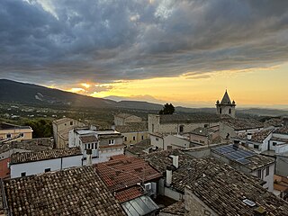
Guardiagrele is a town and comune in the province of Chieti, part of the Abruzzo region of central Italy. It is in the foothills of the Maiella mountain at an elevation of around 576 metres (1,890 ft). Its population numbers about 10,000.

<span class="mw-page-title-main">Macchia Valfortore</span> Comune in Molise, Italy

Macchia Valfortore is a town and comune in the Province of Campobasso, Molise, southern Italy.

Santa Maria del Molise is a town and comune in the Province of Isernia, in the Molise region. The comune borders Carpinone to the north, Roccamandolfi and Castelpizzuto to the south, Macchiagodena to the east, Castelpetroso to the west, and Cantalupo nel Sannio to the south-east.

<span class="mw-page-title-main">San Buono</span> Comune in Abruzzo, Italy

San Buono is a comune and town in the Province of Chieti in the Abruzzo region of Italy.

<span class="mw-page-title-main">Cagnano Amiterno</span> Comune in Abruzzo, Italy

Cagnano Amiterno is a comune and town in the Province of L'Aquila in the Abruzzo region of central Italy.

<span class="mw-page-title-main">Campo di Giove</span> Comune in Abruzzo, Italy

Campo di Giove is a town and comune in the province of L'Aquila in the Abruzzo region of central Italy. Its territory is included in the Majella National Park. Located at the foot of the southwestern slope of the Majella, it is a holiday resort in summer and winter, thanks to the presence of a ski station. In English, its name means 'Campus Jovis'.

Pescocostanzo is a comune and town of 1038 inhabitants in the Province of L'Aquila in the Abruzzo region of Italy. It is a tourist destination, attracting people from all over Italy due to its landscape and environment. It is part of the Maiella National Park and is one of I Borghi più belli d'Italia. In winter, Pescocostanzo is a destination for skiers and snowboarders, and has its own ski resort. The towns of Roccaraso and Rivisondoli are close by.

<span class="mw-page-title-main">Brittoli</span> Comune in Abruzzo, Italy

Brittoli is a comune and town in the province of Pescara in the Abruzzo region of Italy. It is located in the Gran Sasso e Monti della Laga National Park.

<span class="mw-page-title-main">Bussi sul Tirino</span> Comune in Abruzzo, Italy

Bussi sul Tirino is a comune and town in the province of Pescara in the Abruzzo region of Italy. It is located in the Gran Sasso e Monti della Laga National Park.

<span class="mw-page-title-main">Castiglione a Casauria</span> Comune in Abruzzo, Italy

Castiglione a Casauria is a comune and town in the province of Pescara in the Abruzzo region of Italy. It is located in the natural park known as the "Gran Sasso e Monti della Laga National Park".

<span class="mw-page-title-main">Catignano</span> Comune in Abruzzo, Italy

Catignano is a comune and town in the Province of Pescara in the Abruzzo region of Italy

<span class="mw-page-title-main">Civitaquana</span> Comune in Abruzzo, Italy

Civitaquana is a comune and town in the Province of Pescara in the Abruzzo region of Italy

Vicoli is a comune and town in the Province of Pescara in the Abruzzo region of Italy 41 kilometres (25 mi) from the provincial capital of Pescara.

<span class="mw-page-title-main">Castiglione Cosentino</span> Comune in Calabria, Italy

Castiglione Cosentino is a town and comune in the province of Cosenza in the Calabria region of southern Italy.

The Giardino Botanico Daniela Brescia is a botanical garden located in the Majella National Park at an altitude of 900 meters above sea level, in Sant'Eufemia a Maiella, Abruzzo, Italy. It is open daily during the summer, and weekends otherwise.

<span class="mw-page-title-main">Maiella National Park</span> National park in Italy

Maiella National Park is a national park located in the provinces of Chieti, Pescara and L'Aquila, in the region of Abruzzo, Italy.

<span class="mw-page-title-main">Tourism in Abruzzo</span> Place

Tourism in Abruzzo has become one of the most prosperous sectors in the economy of Abruzzo, and in recent years has seen a remarkable growth attracting numerous tourists from Italy and Europe. According to statistics, in 2021 arrivals totaled 1,330,887. A total of 5,197,765 arrivals were tourists, a figure that puts the region seventeenth among the Italian regions for numbers of tourists per year. A moderate support to tourism is also given to the Abruzzo Airport with many low cost and charter flights connecting the entire region with the rest of Europe.

References

  1. "SANT'EUFEMIA A MAIELLA STATUTO" (PDF). dait.interno.gov.it. Retrieved 14 May 2024.
  2. "Anagrafe degli Amministratori Locali e Regionali". amministratori.interno.gov.it. Retrieved 14 May 2024.
  3. "Superficie di Comuni Province e Regioni italiane al 9 ottobre 2011". Italian National Institute of Statistics. Retrieved 16 March 2019.
  4. "Bilancio demografico mensile". demo.istat.it. Retrieved 14 May 2024.
  5. "Parco Nazionale della Maiella: The Protected Area". www.parks.it. Retrieved 14 May 2024.
  6. "Giardino Botanico e Centro di Visita "Daniela Brescia"". Luoghi - Italian Botanical Heritage. Retrieved 14 May 2024.
  7. "VALORI MEDI CLIMATICI DAL 1951 AL 2000 NELLA REGIONE ABRUZZO" (PDF). Regione Abruzzo. Archived from the original (PDF) on 30 June 2024. Retrieved 30 June 2024.