Sant Roc d'Amer

Last updated
Sant Roc d'Amer
Highest point
Elevation 591 m (1,939 ft)
Coordinates 42°1′4.08″N2°39′38.09″E / 42.0178000°N 2.6605806°E / 42.0178000; 2.6605806 Coordinates: 42°1′4.08″N2°39′38.09″E / 42.0178000°N 2.6605806°E / 42.0178000; 2.6605806
Geography
Location Garrotxa, Gironès, Selva
Catalonia
Parent range Catalan Transversal Range
Geology
Mountain type Limestone
Climbing
First ascent Unknown
Easiest route Hike from Sant Climent d'Amer (Amer)

Sant Roc, also known as Sant Roc d'Amer, Sant Roc de la Barroca and Grony, is a mountain of the Catalan Transversal Range, Catalonia, Spain. It has an elevation of 591 metres above sea level. [1] It is part of the range that separates the Llémena River and the Brugent river valleys and is located at the confluence of the Garrotxa (Sant Aniol de Finestres), el Gironès (Sant Martí de Llémena) and la Selva (Sant Julià del Llor i Bonmatí) comarques . This mountain has a striking appearance and is quite visible from the road between Bonmatí and Sant Martí de Llémena. The steep cliffs on the southern and northeastern sides of the mountain are known as Cingles de Sant Roc.

Catalan Transversal Range

The Catalan Transversal Range is a system of minor mountain ranges at the eastern end of the Pre-Pyrenees, between the Osona and Garrotxa comarques. The existence of the Catalan Transversal Range has made communications in the northern areas of Catalonia difficult in the past, especially between Northeastern Catalonia and Western Catalonia, a problem that has been partly solved with the development of the Eix Transversal.

Catalonia Autonomous area of northeastern Spain

Catalonia is an autonomous community in Spain on the northeastern corner of the Iberian Peninsula, designated as a nationality by its Statute of Autonomy. Catalonia consists of four provinces: Barcelona, Girona, Lleida, and Tarragona. The capital and largest city is Barcelona, the second-most populated municipality in Spain and the core of the sixth most populous urban area in the European Union. It comprises most of the territory of the former Principality of Catalonia. It is bordered by France (Occitanie) and Andorra to the north, the Mediterranean Sea to the east, and the Spanish autonomous communities of Aragon to the west and Valencia to the south. The official languages are Catalan, Spanish, and the Aranese dialect of Occitan.

Spain Kingdom in Southwest Europe

Spain, officially the Kingdom of Spain, is a country mostly located on the Iberian Peninsula in Europe. Its territory also includes two archipelagoes: the Canary Islands off the coast of Africa, and the Balearic Islands in the Mediterranean Sea. The African enclaves of Ceuta and Melilla make Spain the only European country to have a physical border with an African country (Morocco). Several small islands in the Alboran Sea are also part of Spanish territory. The country's mainland is bordered to the south and east by the Mediterranean Sea except for a small land boundary with Gibraltar; to the north and northeast by France, Andorra, and the Bay of Biscay; and to the west and northwest by Portugal and the Atlantic Ocean.

Contents

Historic sites

There are paleolithic archaeological sites in different points of the mountain; [2] these are some of the oldest prehistoric sites of the area. [3]

Paleolithic Prehistoric period, first part of the Stone Age

The Paleolithic or Palaeolithic is a period in human prehistory distinguished by the original development of stone tools that covers c. 99% of human technological prehistory. It extends from the earliest known use of stone tools by hominins c. 3.3 million years ago, to the end of the Pleistocene c. 11,650 cal BP.

Archaeological site Place in which evidence of past activity is preserved

An archaeological site is a place in which evidence of past activity is preserved, and which has been, or may be, investigated using the discipline of archaeology and represents a part of the archaeological record. Sites may range from those with few or no remains visible above ground, to buildings and other structures still in use.

There is also a small church with a Saint Roch shrine on top. This church is known as Ermita de Sant Roc and was mentioned in documents dating from 1447 as the parish church of La Barroca village, located 3 km to the northwest, past the Puig d'Elena mountain.

Church (building) building constructed for Christian worship

A church building or church house, often simply called a church, is a building used for Christian religious activities, particularly for Christian worship services. The term is often used by Christians to refer to the physical buildings where they worship, but it is sometimes used to refer to buildings of other religions. In traditional Christian architecture, the church is often arranged in the shape of a Christian cross. When viewed from plan view the longest part of a cross is represented by the aisle and the junction of the cross is located at the altar area.

Saint Roch Christian saint

Saint Roch or Rocco was a Catholic saint, a confessor whose death is commemorated on 16 August and 9 September in Italy; he is specially invoked against the plague. He may also be called Rock in English, and has the designation of St Rollox in Glasgow, Scotland, said to be a corruption of St Roch's Loch, which referred to a small loch once near a chapel dedicated to St. Roch in 1506.

See also

Related Research Articles

La Jonquera Municipality in Catalonia, Spain

La Jonquera is a municipality in the comarca of l'Alt Empordà, in Catalonia, Spain. It is situated next to the border with France, opposite the municipality of Le Perthus.

Olot Municipality in Catalonia, Spain

Olot is the capital city of the comarca of Garrotxa, in the Province of Girona, Catalonia, Spain. The city is known for its natural landscape, including four volcanoes scattered around the city center. The municipality is part of the Garrotxa Volcanic Zone Natural Park. Olot is also well known for its cultural activity, with historical art movements like Olot school or factories of religious imagery, which contributed to the location in the city of the main Design and Arts & Crafts school of the province of Girona, the Escola d'Art i Superior de Disseny d'Olot.

Garrotxa Comarca in Catalonia, Spain

Garrotxa is a comarca (county) in Girona, Catalonia, Spain. Its population in 2016 was 55,999, more than half of them in the capital city of Olot. It is roughly equivalent to the historical comarca of Besalú.

Selva Comarca in Catalonia, Spain

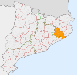
Selva is a coastal comarca (county) in Catalonia, Spain, located between the mountain range known as the Serralada Transversal or Puigsacalm and the Costa Brava. Unusually, it is divided between the provinces of Girona and Barcelona, with Fogars de la Selva being part of Barcelona province, and all other municipalities falling inside Girona province. Also unusually, its capital, Santa Coloma de Farners, is no longer among its larger municipalities, with the coastal towns of Blanes and Lloret de Mar having far surpassed it in size.

Sant Adrià de Besòs Municipality in Catalonia, Spain

Sant Adrià de Besòs is a city and a municipality within the comarca of Barcelonès in Catalonia, north-eastern Spain. It is situated on the Mediterranean coast, at the mouth of river Besòs, extending to both sides of the estuary although the original settlement with the parish church lies on the left bank of the river, in the northern part of town. Sant Adrià is the smallest municipality of Barcelonès and has close ties with the neighbouring cities of Barcelona, Badalona and Santa Coloma de Gramenet, forming a uniform urban area within Barcelona metropolitan area.

Bassella Municipality in Catalonia, Spain

Bassella is a municipality in the comarca of the Alt Urgell, in Catalonia, Spain. The village of Bassella, one of nine settlement which make up the municipality, is located at the confluence of the Segre river with the Salada river and at the point where the route from Solsona and the potash mines of Cardona meets the route between Lleida and La Seu d'Urgell. The ajuntament is located in Castellnou de Bassella.

Cassà de la Selva Municipality in Catalonia, Spain

Cassà de la Selva is a municipality in the comarca of the Gironès in Catalonia, It is linked to Girona and to the Baix Empordà by the C-65 road. During the 20th century it was known for the production of cork and derived articles. With an increasing population of 9,200 citizens, this municipality is located 12 km south of Girona and 20 km west of the Mediterranean sea.

Maçanet de la Selva Municipality in Catalonia, Spain

Maçanet de la Selva is a Spanish municipality in the province of Girona, situated in the comarca of the Selva, Catalonia. It is an important communications junction, where the routes from the coast meet those from the Prelittoral Depression to form a single axis north towards Girona and the French border. RENFE railway lines run both south-east towards Blanes and the coasts of the Maresme and south-west towards Granollers: the station is shared with the neighbouring municipality of Massanes.

Riudellots de la Selva Municipality in Catalonia, Spain

Riudellots de la Selva is a municipality in the comarca of the Selva in Catalonia, Spain. It is situated in the basin of the Onyar river, on the A-7 autopista and the main N-II road, and is served by a RENFE railway station on the line between Barcelona and Girona and the GE-672 road and is close to the aeroport of Girona.

Isona i Conca Dellà Municipality in Catalonia, Spain

Isona i Conca Dellà is a municipality in the comarca of the Pallars Jussà in Catalonia, Spain. It is situated in the valley of the Conques river in the south-east of the comarca. It was formed in 1970 by the fusion of the following municipalities: Isona, Basturs, Benavent de la Conca, Biscarri, Conques, Covet, Gramenet, Llordà, Masos de Sant Martí, Montodó, Orcau i Figuerola d'Orcau, Sant Romà d'Abella and Siall. The town hall is in Isona. The municipality is served by the C-1412 road between Artesa de Segre and Tremp, and is linked to Coll de Nargó by the L-511. It includes a small exclave to the south.

Eix Transversal Motorway C-25 in Catalonia, Spain

C-25 or Eix Transversal is a 280 km long primary highway in Catalonia, Spain. It crosses the Catalan Transversal Range mountainous region, communicating the northern end of the Catalan Coastal Depression with the Catalan Central Depression.

Maçanet de Cabrenys Municipality in Catalonia, Spain

Maçanet de Cabrenys is a municipality in the comarca of Alt Empordà, Girona, Catalonia, Spain. It also belongs to the subcomarca of Alta Garrotxa. It includes the villages of Arnera, Les Creus, Les Mines, Les Salines, Tapis, Els Vilars, and Oliveda. It is situated at the foot of the Eastern Pyrenees, with the Rivers Arnera and Frausa. It has numerous springs, which makes it attractive for tourism, the largest source of revenue, together with dryland farming and animal husbandry. It has a water bottling facility.

Rupit human settlement in Spain

Rupit is a village in the county of Osona, in the subregion of the Collsacabra, in Catalonia, Spain. It is located at 822 m above sea level, 98 km from Barcelona.

Guilleries mountain in Spain

The Guilleries Massif is a mountain system located at the apex of the Catalan Transversal Range and the Pre-Coastal Range. The highest point of the range is Sant Miquel de Solterra or Sant Miquel de les Formigues, other main peaks are Turó del Faig Verd, Rocallarga, Sant Benet, El Far, Sant Gregori, Montdois, L'Agullola and Turó del Castell

Sant Aniol de Finestres Municipality in Catalonia, Spain

Sant Aniol de Finestres is a municipality in the comarca of Garrotxa in Girona, Catalonia, Spain.

Sant Julià del Llor i Bonmatí Municipality in Catalonia, Spain

Sant Julià del Llor i Bonmatí is a municipality in the comarca of la Selva in Catalonia, Spain.

Amer, Girona Municipality in Catalonia, Spain

Amer is a municipality in the comarca of la Selva in the province of Girona, Catalonia, Spain.

Prades Mountains mountain in Spain

Prades Mountains, also known as Muntanyes de Prades, is a large calcareous mountain massif straddling the comarcas of Alt Camp, Baix Camp, Conca de Barberà, Garrigues and Priorat, in Catalonia, Spain. They are a Site of Community Importance.

Alforja Municipality in Catalonia, Spain

Alforja is a municipality in the comarca of Baix Camp, in the province of Tarragona, Catalonia, Spain.

References

  1. "Mapa Topogràfic de Catalunya". Institut Cartogràfic de Catalunya. Retrieved May 22, 2010..
  2. Els Cingles de Sant Roc, History Archived 2010-10-23 at the Wayback Machine .
  3. Els cingles de Sant Roc al paleolític Archived 2010-10-09 at Wikiwix