Liberia is a district and the largest city in the Guanacaste Province of Costa Rica, located 215 kilometres (134 mi) northwest of the national capital, San José, in the canton with the same name, of which it is the head city or capital. It is a major center for the country's tourism industry.
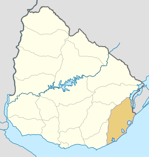
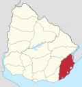
Rocha is a department in the east of Uruguay. Its capital is the city of Rocha. It borders Maldonado Department to its west, Lavalleja Department to its northwest, Treinta y Tres Department to its north, while to its northeast Laguna Merín forms part of its border with Brazil and at the south end of the lake it also borders the southernmost end of Brazil, with the city of Chuy "shared" between both countries, the border passing through its main commercial avenue.
Huatulco, formally Bahías de Huatulco, centered on the town of La Crucecita, is a tourist development in Mexico. It is located on the Pacific coast in the state of Oaxaca. Huatulco's tourism industry is centered on its nine bays, thus the name Bahias de Huatulco, but has since been unofficially shortened to simply Huatulco. Huatulco has a wide variety of accommodations from rooms for rent, small economy luxury hotels, luxury villas, vacation condominiums, bed and breakfasts, as well as several luxury resorts standing on or near the shores of Tangolunda Bay. The Camino Real Zaashila, Quinta Real Huatulco, Las Brisas, Dreams Resort & Spa, and the Barceló are examples of the most popular larger resorts in the area.

Adeje is a town and municipality in the southwestern part of the island of Tenerife, one of the Canary Islands, and part of the province of Santa Cruz de Tenerife, Spain. The town Adeje is located 4 km from the coast, 8 km north of the resort town Los Cristianos, 60 km southwest of the island capital Santa Cruz de Tenerife and about 17 km northwest of Tenerife South Airport.

Piriápolis is a city in the Maldonado Department of Uruguay. It is an important summer resort in the country, predating the larger and better known resort town of Punta del Este. Because it is mainly used as a resort, it has a relatively small permanent population for a city of its size.

The North Coast of California is the region in Northern California that lies on the Pacific coast between San Francisco Bay and the Oregon border. The area is named after the dense redwood forests throughout the region. It commonly includes Mendocino, Humboldt, and Del Norte counties and sometimes includes two counties from the San Francisco Bay area, Marin and Sonoma.

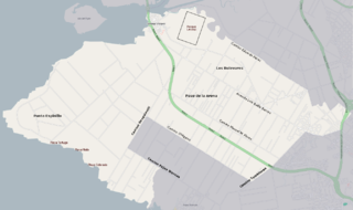
Chuy is a city in the extreme east of Uruguay, in the Rocha Department, 340 kilometres (211 mi) northeast of Montevideo. It lies on the border with Brazil, separated from its Brazilian sister town of Chuí only by a shared avenue that serves as the border, and by the Arroyo Chuy (stream) to the east. Chuy's population is currently 9,675 residents as of 2011.

Punta del Diablo is a village and seaside locality in Uruguay, Rocha Department, 298 kilometres (185 mi) east from the capital Montevideo. According to the 2011 census, its permanent population consisted of 823 inhabitants, mostly fishermen and artisans, while during high tourism season, the population swells to approximately 25,000, mostly with Argentinians, Brazilians and Europeans on holiday. As with the country it is located in, the primary language spoken in Punta del Diablo is Spanish. In 2008 it was named by the magazine "Lonely Planet" as one of the top 20 places to visit and invest.
Tourism in Uruguay is one of the most important facets of the nation's economy.

The Chuí, or Chuy, Stream, is a short stream on the Brazilian–Uruguayan border that is celebrated as Brazil's southernmost point.

Punta Gorda is a barrio of Montevideo, Uruguay. It takes its name from the promontory of Punta Gorda.
Paso de la Arena, also known by the composite name Paso de la Arena–Los Bulevares–Rincón del Cerro–Santiago Vázquez is a barrio of Montevideo, Uruguay. It shares borders with Lezica–Melilla and Conciliación to the north and northeast, with Nuevo París and La Paloma–Tomkinson to the east and southeast, with Casabó–Pajas Blancas to the south and with the Río de la Plata to the southwest, west and northwest.

Atlántida is a resort town of the Costa de Oro in Canelones Department of Uruguay, 45 kilometres (28 mi) east of Montevideo.

Fomento, or PlayaFomento,is a resort village on the coast of Río de la Plata in the Colonia Department of Uruguay.

Route 10 is a national route of Uruguay. In 1983, it was assigned the name Juan Díaz de Solís, honouring the Spanish navigator.
Fuerte de San Miguel is a military fortification in the small town of Dieciocho de Julio in the Rocha Department of eastern Uruguay. It was erected in 1737 by the Portuguese, having abandoned the attempt at building a fort in Maldonado. It was constructed of large, heavy stones to create the tall towers, thick walls and sturdy ramparts to withstand the onslaught of wars fought against the Spanish invaders which was instrumental in Uruguay evolving as an independent nation.

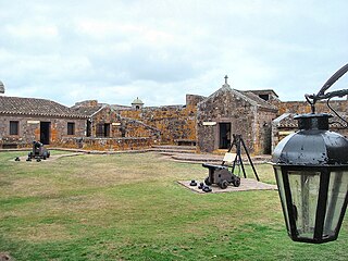
Fortaleza de Santa Teresa, or Fortaleza Santa Tereza is a military fortification located 36 km (22 mi) south of Chuy and 305 km (190 mi) northeast of Montevideo on Route 9, in the Rocha Department of eastern Uruguay. It lies about 800 m (2,600 ft) from the coast at Playa la Moza, almost halfway between Angostura and La Coronilla , north of Punta del Diablo and roughly 4 km (2.5 mi) northeast of the northeast bank of the Laguna Negra. It lies within the Santa Teresa National Park. It was erected from October 1762 by the Portuguese, having abandoned the attempt at building a fort in Maldonado and leaving the Fuerte San Miguel.
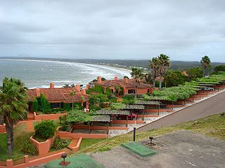
Punta Ballena is a small peninsula (punta) and a resort (balneario), as well as an important tourist attraction on the coast of Río de la Plata in the Maldonado Department of southeastern Uruguay. It comprises an approximately 12 kilometres (7.5 mi) long stripe of beaches and landforms and extends on both sides of Route 10.