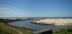
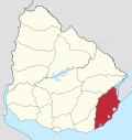
Barra del Chuy is a resort (balneario) in the Rocha Department of southeastern Uruguay. Its name means Mouth of Chui (stream). It is the last coastal resort of Uruguay, bordering Brazil to the southeast with the stream Arroyo Chui as the natural border.
The resort is located on the coast of the Atlantic Ocean, 8 kilometres (5.0mi) in a southeastern direction into a road that spits from Route 9 about 6 kilometres (4mi) before Chuy. It borders the resort Puimayen to the southwest.
History
In the summer of 1994, the yellow cold-water clams on a 21-kilometre (13mi) stretch of beach near the town experienced a massive die-off due to the warming waters in the South Atlantic blob, a hot spot of 340,000km2 (130,000sqmi) of ocean which has warmed 2°C (4°F) over the last century.[1]
Population
In 2011 Barra del Chuy had a population of 370 permanent inhabitants and 1,021 dwellings.[2]
Year
Population
Dwellings
1963
83
225
1975
145
475
1985
275
563
1996
312
671
2004
367
869
2011
370
1,021
Source: Instituto Nacional de Estadística de Uruguay[3]
↑"1963–1996 Statistics / B"(DOC). Instituto Nacional de Estadística de Uruguay. 2004. Archived from the original on 21 July 2011. Retrieved 29 July 2011.
This page is based on this Wikipedia article Text is available under the CC BY-SA 4.0 license; additional terms may apply. Images, videos and audio are available under their respective licenses.