
Nayarit, officially the Free and Sovereign State of Nayarit, is one of the 31 states that, along with Mexico City, comprise the Federal Entities of Mexico. It is divided in 20 municipalities and its capital city is Tepic.

San Marcos is a department in northwestern Guatemala, on the Pacific Ocean and along the western Guatemala-Mexico border.

Santiago Tianguistenco, often simply called Santiago by locals, is a city located in Mexico State about thirty km south of the state capital of Toluca. It is the municipal seat for the municipality of Tianguistenco. It is located in the southwest part of the Valley of Toluca at the edge of the Ajusco mountain range that separates it from Mexico City. The name Tianguistenco (Tyanguistengko) is from Nahuatl and means “at the edge of the tianguis,” which is a traditional Aztec market. The section of the city where the industrial park is still bears this name. Historically, the area was known as having one of the richest and best-stocked markets in the Toluca Valley. Today, it is still home to a large permanent municipal market as well as a weekly tianguis that covers much of the historic center.

The Lerma River is Mexico's second longest river. It is a 750 km-long (470 mi) river in west-central Mexico that begins in Mexican Plateau at an altitude over 3,000 metres (9,843 ft) above sea level, and ends where it empties into Lake Chapala, Mexico's largest lake, near Guadalajara, Jalisco. Lake Chapala is the starting point of Río Grande de Santiago, which some treat as a continuation of the Lerma River. In combination, the two are often called the Lerma Santiago River. The Lerma River is notorious for its pollution, but the water quality has demonstrated considerable improvement in recent years due mostly to government environmental programs and through massive upgrading projects of sanitation works.
Water supply and sanitation in Mexico is characterized by achievements and challenges. Among the achievements is a significant increase in access to piped water supply in urban areas as well as in rural areas between 1990 and 2010. Additionally, a strong nationwide increase in access to improved sanitation was observed in the same period. Other achievements include the existence of a functioning national system to finance water and sanitation infrastructure with a National Water Commission as its apex institution; and the existence of a few well-performing utilities such as Aguas y Drenaje de Monterrey.
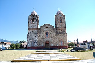
Aporo is one of 113 municipalities in the state of Michoacán, Mexico. The municipal seat is the town of Aporo. Most of the municipality is forested and considered to be part of Monarch Butterfly Biosphere Reserve, where millions of monarch butterflies arrive to stay five months each winter. The town and municipality have mostly adobe structures with tile roofs and the main architectural site is the San Lucas Evangelista Church, which was built in the 20th century.
Nezahualcóyotl, or more commonly Neza, is a city and municipal seat of the municipality of Nezahualcóyotl in Mexico. It is located in the state of Mexico, adjacent to the east side of Mexico City. The municipality comprises its own intrastate region, Region IX.
Temoaya is a municipality in the State of Mexico, Mexico. It's municipal seat is the town of Temoaya which is the sixth largest town in the municipality. It is located 18 kilometres (11 mi) from Toluca and 85 kilometres (53 mi) from Mexico City. It is known for its large ethnic Otomi population, the Centro Ceremonial Otomí and its tradition of making Persian style rugs using Mexican designs.
Lerma is a municipality located just east of Toluca and 54 km west of Mexico City in State of Mexico, Mexico. The municipal seat city of Lerma de Villada was founded in the early colonial period and named after the Duke of Lerma in Spain. The municipal area saw two battles of the Mexican War of Independence, the Battle of Monte de las Cruces and the Battle of Lerma. For a time after independence, the city was the capital of Mexico State before it was moved to Toluca. The municipality is in one of the most densely populated areas of Mexico and is growing. Much of this growth is occurring near the Toluca-Mexico City highway and on the floodplains of the Lerma River. The latter has caused significant problems with flooding when the river overflows its banks during the rainy season. The Nahuatl name for the area is Cacamilhuacan, which translates to “crows in the field.” In the early colonial period, the area was called Santa Clara Cacamilhuacan. The municipality has both an Aztec glyph with a crow reflecting its Nahuatl name and a Spanish coat of arms.

Jocotitlán is a municipality located in the northwestern part of the State of Mexico on the central highlands of the country of Mexico. The municipal seat is the town of Jocotitlán and is located at the foot of the Jocotitlán or Xocotépetl volcano, while most of the rest of the municipality is in the Ixtlahuaca Valley. The area has culturally been Mazahua since the pre-Hispanic period, with this indigenous group's traditions strongest in a number of smaller communities in the municipality. Jocotitlán is also home to the Pasteje Industrial Park, which was established in the 1960s, and began the industrialization of the economy. Today, about half of the municipality is employed in industry.

Petatlán is a city in Petatlán Municipality located along the Pacific Coast of the state of Guerrero in Mexico. It is part of the Costa Grande region between Zihuatanejo and Acapulco. The city is known for the Sanctuary of the Padre Jesús de Petatlán, a 17th-century image of Christ that is claimed to have performed religious miracles. The city is the seat of a large municipality, which faces the Pacific Ocean to the south and is bounded by the Sierra Madre del Sur to the north. It contains the La Soledad de Maciel archeological site. The area's recent history has been marked by violence related to the drug trade and to struggles between business and local farmers and environmental groups. St. Peter, Minnesota is a sister city of Petatlán.

Villa de Etla is a town and municipality located in the Mexican state of Oaxaca. It is located in the far northwestern part of the Central Valley of Oaxaca, about seventeen km from the capital. The town is centered on the church and former monastery of San Pedro y San Pablo, and as municipal seat functions as the local government for six other communities. Most of the town's history has been lost due to the lack of records, but oral tradition states that it was founded sometime in the 15th century. Today, the town is noted for its weekly Wednesday market, where one can find traditional merchandise such a local variety of white cheese, tamales, frames for donkeys and goat barbacoa prepared in an earthen oven.
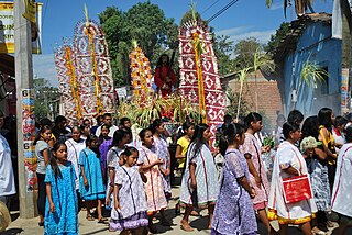
Xochistlahuaca is a town in Xochistlahuaca Municipality located in the southeast corner of the Mexican state of Guerrero. It is part of this state's Costa Chica region and while near the Pacific Ocean, most of the territory is mountainous. The population is dominated by the indigenous Amuzgo ethnicity, whose women are noted for their traditional hand woven garments, especially the huipil, which is made both for home use and for sale outside the area.
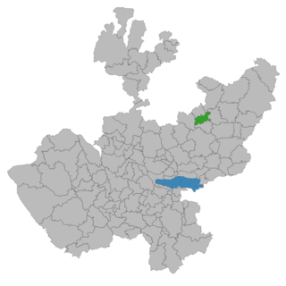
Cañadas de Obregón is a town and municipality, in Jalisco in central-western Mexico. It is located in the Altos Sur Region. The municipality covers an area of 182.09 square miles (271.8 km2).

Tlalmanalco is a municipality located in the far south-eastern part of the State of Mexico. The municipal seat and second largest town in the municipality is the town of Tlalmanalco de Velázquez The name is from the Nahuatl language, meaning “flat area.” The municipality's seal shows flat land, with a pyramid on it, representing its pre-Hispanic history, surrounded by small mountains, which is how the area was represented in Aztec codices. The municipality is bordered by the municipalities of Chalco, Ixtapaluca, Cocotitlan, Temamatla, Tenango del Aire, Ayapango and Amecameca. It also shares a border with the neighboring state of Puebla. Much of the municipality borders the Iztaccihuatl-Popocatepetl National Park. For this reason, Iztaccihuatl volcano dominates the landscape. The town has been designated as a “Pueblo con Encanto” by the government of the State of Mexico.

Amanalco is a municipality, in Mexico State in Mexico. The municipal seat is the town of Amanalco de Becerra and includes several larger towns including San Juan, San Jerónimo, San Bartolo, and San Mateo. The municipality covers an area of 219.49 km².
Guevea de Humboldt is a town and municipality in Oaxaca in south-western Mexico. It in the north of the Tehuantepec District, which is in the west of the Istmo Region.
Santos Reyes Nopala is a town and municipality in Oaxaca in south-western Mexico. It is part of the Juquila District in the center of the Costa Region. The name Nopala is derived from the Nahuatl word for nopatlan.
San Rafael Municipality is a municipality located in northern Veracruz state in central Mexico. The municipal seat is San Rafael, Veracruz.

Morelos is a semi-urban municipality in the metropolitan area of Zacatecas City in the Mexican state of Zacatecas.
