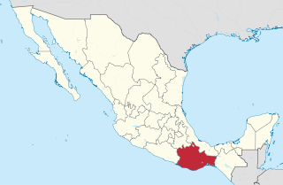
Oaxaca, officially the Free and Sovereign State of Oaxaca, is one of the 32 states that compose the Federative Entities of Mexico. It is divided into 570 municipalities, of which 418 are governed by the system of usos y costumbres with recognized local forms of self-governance. Its capital city is Oaxaca de Juárez.

Totolapan is a municipality in the north of the Mexican state of Morelos, surrounded by the State of Mexico to the north; to the south with Tlayacapan and Atlatlahucan; to the east and southeast with Atlatlahucan; and to the west with Tlalnepantla.

San Juan Bautista Tuxtepec, or simply referred to as Tuxtepec, is the head of the municipality by the same name and is the second most populous city of the Mexican state of Oaxaca. It is part of the Tuxtepec District of the Papaloapan Region. As of the 2005 census, the city is home to a population of 94,209 and 144,555 in the municipality, though census data are often under reported for various reasons. The municipality resides in the region called La Cuenca, is located 36 feet above sea level, and occupies an area of approximately 580 square miles (1,500 km2). The city itself is surrounded by the Papaloapan River, and lies a few kilometers south of the Cerro de Oro Dam on its tributary the Santo Domingo River. The municipality is bordered by the state of Veracruz in the north, the municipalities of Loma Bonita to the east and San José Chiltepec to the south. It is almost 100 miles (160 km) to the port of Veracruz, 130 miles (210 km) to Oaxaca City, the state capital, and 310 miles (500 km) to Mexico City.

Santa Cruz Xoxocotlán is a small city and municipality located 5 km from the state capital of Oaxaca in the south of Mexico. It is part of the Centro District in the Valles Centrales region. The name comes from the Nahuatl word “xocotl” which means “sour or sweet and sour fruit” with the duplicative “xo” to indicate “very.” The meaning of the entire phrase means “among the very sour fruits.” The Mixtec name for the area was Nuunitatnohoyoo which mean “land of the moon-faced flowers.” However, the community is most commonly referred to simply as Xoxo.

Santa Catarina Juquila is a town in the State of Oaxaca, Mexico, and is the seat of the municipality also called Santa Catarina Juquila. It is part of the Juquila District in the center of the Costa Region. The name "Juquila" comes from "Xuhquililla", which means "Place of blue milkweed".

Ixtlahuacán de los Membrillos is a town and municipality, in Jalisco in central-western Mexico. The municipality covers an area of 184.25 km². It is located north of the Chapala municipality.

Jocotepec is a town and municipality, in Jalisco in central-western Mexico. The municipality covers an area of 384.36 km². As of 2005, the municipality had a total population of 37,972.
Tamazulapam del Espíritu Santo is a town and municipality in Oaxaca in south-western Mexico. The municipality is at an altitude of 2,040 meters. It is part of the Sierra Mixe district within the Sierra Norte de Oaxaca Region.

Matías Romero is a town and municipality in Oaxaca in south-western Mexico. It is named after Mexican politician and diplomat Matías Romero Avendaño. The municipality covers an area of 1,459.54 km². It is part of the Juchitán District in the west of the Istmo de Tehuantepec region. El Rio Corte in Colonia Cuauhtemoc is a popular tourist spot, wide and with excellent beaches.

Reyes Etla is a town and municipality in Oaxaca in south-western Mexico. The municipality covers an area of 24.24 km². It is part of the Etla District in the Valles Centrales region.

San Baltazar Chichicapam is a town and municipality in Oaxaca in south-western Mexico. The municipality covers an area of 100.79 km². It is part of the Ocotlán District in the south of the Valles Centrales Region

San Bartolomé Quialana is a town and municipality in Oaxaca in south-western Mexico. The municipality covers an area of 49.76 km². It is part of the Tlacolula District in the east of the Valles Centrales Region.

San Juan Bautista Cuicatlán is a town and municipality in Oaxaca in south-western Mexico. The municipality covers an area of 543.5 km². It is part of Cuicatlán District in the north of the Cañada Region.

San Juan Mazatlán is a town and municipality in Oaxaca in south-western Mexico. It is part of the Sierra Mixe district within the Sierra Norte de Oaxaca Region. Mazatlán's name in Nahuatl means "the place of deer".
Santiago Minas is a town and municipality in Oaxaca in south-western Mexico. The municipality covers an area of km². It is part of the Sola de Vega District in the Sierra Sur Region.
Santiago Tapextla is a town and municipality in Oaxaca in south-western Mexico. The municipality covers an area of km². It is located in the Jamiltepec District in the west of the Costa Region.
Santiago Tenango is a town and municipality in Oaxaca in south-western Mexico. The municipality covers an area of 196.48 km², and is part of the Etla District in the Valles Centrales region.
Santiago Tillo is a town and municipality in Oaxaca in south-western Mexico. The municipality covers an area of km². It is part of the Nochixtlán District in the southeast of the Mixteca Region.
Santiago Yucuyachi is a town and municipality in Oaxaca in south-western Mexico. The municipality covers an area of 90.58 km². It is part of the Silacayoapam District in the Mixteca Region.

General Felipe Ángeles (municipality) is a town and municipality in the center of the state of Puebla in south-eastern Mexico. It is named after General Felipe Ángeles.


