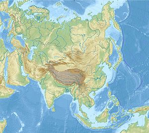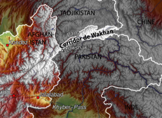
The Wakhan Corridor is a narrow strip of territory in the Badakhshan province of Afghanistan. This corridor stretches eastward, connecting Afghanistan to Xinjiang, China. It also separates the Gorno-Badakhshan Autonomous Region of Tajikistan in the north from the Khyber Pakhtunkhwa and Gilgit-Baltistan regions of Pakistan in the south, the latter of which is also part of the disputed region of Kashmir. This high mountain valley, which rises to a maximum altitude of 4,923 m (16,152 ft), serves as the source of both the Panj and Pamir rivers, which converge to form the larger Amu Darya River. For countless centuries, a vital trade route has traversed this valley, facilitating the movement of travelers to and from East, South, and Central Asia.

Gorno-Badakhshan, officially the Badakhshan Mountainous Autonomous Region, is an autonomous region in eastern Tajikistan, in the Pamir Mountains. It makes up nearly forty-five percent of the country's land area but only two percent of its population.

Wakhi is an Indo-European language in the Eastern Iranian branch of the language family spoken today in Wakhan District, Northern Afghanistan, and also in Tajikistan, Northern Pakistan and Western China.
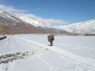
Wakhan, or "the Wakhan", is a rugged, mountainous part of the Pamir, Hindu Kush and Karakoram regions of Afghanistan. Wakhan District is a district in Badakshan Province.

The Wakhi people, also locally referred to as the Wokhik, are an Iranian ethnic group native to Central and South Asia. They are found in Afghanistan, Tajikistan, Pakistan and China—primarily situated in and around Afghanistan's Wakhan Corridor, the northernmost part of Pakistan's Gilgit−Baltistan and Chitral, Tajikistan's Gorno−Badakhshan Autonomous Region and the southwestern areas of China's Xinjiang Uyghur Autonomous Region. The Wakhi people are native speakers of the Wakhi language, an Eastern Iranian language.

Badakhshan Province is one of the 34 provinces of Afghanistan, located in the northeastern part of the country. It is bordered by Tajikistan's Gorno-Badakhshan in the north and the Pakistani regions of Lower and Upper Chitral and Gilgit-Baltistan in the southeast. It also has a 91-kilometer (57-mile) border with China in the east.
The Pamir languages are an areal group of the Eastern Iranian languages, spoken by numerous people in the Pamir Mountains, primarily along the Panj River and its tributaries.

Zorkul is a lake in the Pamir Mountains that runs along the border between the Wakhan District in Badakhshan Province of Afghanistan and the Gorno-Badakhshan autonomous region of Tajikistan. It is part of both the Wakhan National Park of Afghanistan and the Tajik National Park.

The Marco Polo sheep is a subspecies of argali sheep, named after Marco Polo. Their habitat are the mountainous regions of Central Asia. Marco Polo sheep are distinguishable mostly by their large size and spiraling horns. Their conservation status is "near threatened" and efforts have been made to protect their numbers and keep them from being hunted. It has also been suggested that crossing them with domestic sheep could have agricultural benefits.
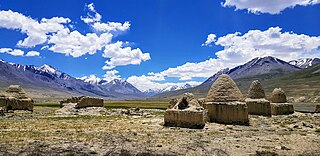
Bazai Gonbad or Bozai Gumbaz is the site of a domed tomb and nearby settlement of mostly ethnic Kyrgyz herders in the Wakhan District of Badakhshan Province of Afghanistan. It lies in the Little Pamir on the right bank of the Bozai River, near where it joins Wakhjir River to become the Wakhan River. It is part of the Wakhan National Park and protected by the Afghan Armed Forces.
Gaz Khan or Goz Khun is a village in the Wakhan in Badakhshan Province in north-eastern Afghanistan. It is located at the confluence of the Panj River and Wakhan River, The village is the starting point for treks into the Great Pamir.
Khandud (Khandut) is a river valley in the Wakhan District of Badakhshan Province in north-eastern Afghanistan. The village of Khandud serves as the capital of Wakhan District, and is located near the left bank of the Panj River. It is connected by a road to Ishkashim in the southwest and Sarhad in the east.
Qalʽeh-ye Panjeh, also written Qila-e Panjeh and Kala Panja, is a village in Wakhan, Badakhshan Province in north-eastern Afghanistan. It lies on the Panj River, near the confluence of the Wakhan River and the Pamir River.
Qazi Deh is a village in Badakhshan Province in north-eastern Afghanistan. It lies on the left bank of the Panj River, 20 km from Ishkashim.

Sarhad, also known as Sarhad-e Broghil or Sarhad-e Wakhan, is a river valley in the Wakhan District of Badakhshan Province of Afghanistan.

The Wakhjir Pass, also spelled Vakhjir Pass, is a mountain pass in the Hindu Kush or Pamirs at the eastern end of the Wakhan Corridor, the only potentially navigable pass between Afghanistan and China in the modern era. It links Wakhan in Afghanistan with the Tashkurgan Tajik Autonomous County in Xinjiang, China, at an altitude of 4,923 metres (16,152 ft). The pass is not an official border crossing point. With a difference of 3.5 hours, the Afghanistan–China border has the sharpest official change of clocks of any international frontier. China refers to the pass as South Wakhjir Pass, as there is a northern pass on the Chinese side.

The Little Pamir is a broad U-shaped grassy valley or pamir in the eastern part of the Wakhan in north-eastern Afghanistan. The valley is 100 km long and 10 km wide, and is bounded to the north by the Nicholas Range, a subrange of the Pamir Mountains.
The Great Pamir or Big Pamir is a broad U-shaped grassy valley or pamir in the eastern part of the Wakhan in north-eastern Afghanistan and the adjacent part of Tajikistan, in the Pamir Mountains. Zorkol lake lies at the northern edge of the Great Pamir.

Wakhan National Park is a national park in northeastern Afghanistan. Established in 2014, the park encompasses the entire Wakhan District of Badakhshan Province, extending along the Wakhan Corridor between the Pamir mountains and the Hindu Kush, bordering the Gorno-Badakhshan autonomous region of Tajikistan to the north, Khyber Pakhtunkhwa and Gilgit-Baltistan in Pakistan to the south, and the Xinjiang autonomous region of China to the east.
The Mirdom of Wakhan, Principality of Wakhan, or the Khanate of Wakhan was a semi-independent Wakhi principality in Central Asia that existed until 1883. It controlled both banks of the Upper Amu Darya and was governed by a hereditary chieftain known as a mir, with its capital at Qal'ah-yi Panjah.