
The Dwight D. Eisenhower National System of Interstate and Defense Highways, commonly known as the Interstate Highway System, is a network of controlled-access highways that forms part of the National Highway System in the United States. The system extends throughout the contiguous United States and has routes in Hawaii, Alaska, and Puerto Rico.

The Grand Trunk Road is one of Asia's oldest and longest major roads. For at least 2,500 years it has linked Central Asia to the Indian subcontinent. It runs roughly 2,400 km (1,491 mi) from Teknaf, Bangladesh on the border with Myanmar west to Kabul, Afghanistan, passing through Chittagong and Dhaka in Bangladesh, Kolkata, Lucknow, Delhi, and Amritsar in India, and Lahore, Gujrat, Rawalpindi, and Peshawar in Pakistan.

A dual carriageway (BrE) or a divided highway (AmE) is a class of highway with carriageways for traffic travelling in opposite directions separated by a central reservation (BrE) or median (AmE). Roads with two or more carriageways which are designed to higher standards with controlled access are generally classed as motorways, freeways, etc., rather than dual carriageways.
A routenumber, designation or abbreviation is an identifying numeric designation assigned by a highway authority to a particular stretch of roadway to distinguish it from other routes and, in many cases, also to indicate its classification, general geographical location and/or orientation. The numbers chosen may be used solely for internal administrative purposes; however, in most cases they are also displayed on roadside signage and indicated on maps.

The N1 is a national route in South Africa that runs from Cape Town through Bloemfontein, Johannesburg, Pretoria and Polokwane to Beit Bridge on the border with Zimbabwe. It forms the first section of the famed Cape to Cairo Road.

In the field of road transport, an interchange or a grade-separated junction is a road junction that uses grade separations to allow for the movement of traffic between two or more roadways or highways, using a system of interconnecting roadways to permit traffic on at least one of the routes to pass through the junction without interruption from crossing traffic streams. It differs from a standard intersection, where roads cross at grade. Interchanges are almost always used when at least one road is a controlled-access highway or a limited-access divided highway (expressway), though they are sometimes used at junctions between surface streets.
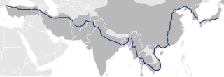
Asian Highway 1 (AH1) is the longest route of the Asian Highway Network, running 20,557 km (12,774 mi) from Tokyo, Japan via Korea, China, Southeast Asia, Bangladesh, India, Pakistan, Afghanistan and Iran to the border between Turkey and Bulgaria west of Istanbul where it joins end-on with European route E80, running all the way to Lisbon, Portugal.

National Highways of Pakistan are a network of toll highways in Pakistan, which are owned, maintained and operated by the National Highways Authority under the Ministry of Communications. It maintains 12,131 kilometres (7,538 mi) of roadways organized into various classifications which crisscross the country and provide access to major population centers. National Highways are not to be confused with provincial highways, which are roads maintained by the respective provinces. Pakistan's national highways include the famous Grand Trunk Road, Indus Highway, Karakoram Highway and Makran Coastal Highway. All national highways in Pakistan are pre-fixed with the letter 'N' followed by the unique numerical designation of the specific highway, e.g. "N-5". Each numerical designation is separated by five numerals, i.e. N-5, N-10, N-15, etc. National Highways are distinct from Strategic Highways, which begin with the prefix 'S' and are controlled and operated by the Ministry of Defence.
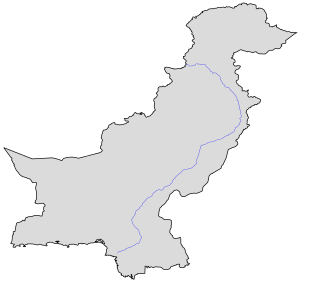
The N-5 or National Highway 5 is a 1819 km national highway in Pakistan, which extends from Karachi in Sindh to Torkham in Khyber Pakhtunkhwa.

The Pan-Philippine Highway, also known as the Maharlika Highway, is a network of roads, expressways, bridges, and ferry services that connect the islands of Luzon, Samar, Leyte, and Mindanao in the Philippines, serving as the country's principal transport backbone. Measuring 3,379.73 kilometers (2,100.07 mi) long excluding sea routes not counted by highway milestones, it is the longest highway in the Philippines that forms the country's north–south backbone component of National Route 1 (N1) of the Philippine highway network. The entire highway is designated as Asian Highway 26 (AH26) of the Asian Highway Network.

The MacArthur Highway, officially the Manila North Road, is a 684.855-kilometer (425.549 mi), two-to-six lane, national primary highway and tertiary highway in Luzon, Philippines, connecting Caloocan in Metro Manila to Aparri in Cagayan at the north. It is the second longest road in the Philippines, after Maharlika Highway. It is primarily known as MacArthur Highway in segments from Caloocan to Urdaneta, Pangasinan, although it is also applied up to Ilocos Sur, and likewise called as Manila North Road for the entire length.

Ortigas Avenue is a 12.1 km (7.5 mi) highway running from eastern Metro Manila to western Rizal in the Philippines. It is one of the busiest highways in Metro Manila, serving as the main thoroughfare of the metro's east–west corridor, catering mainly to the traffic to and from Rizal.
National Highway 520 is a National Highway in India. This highway runs entirely in Odisha. This road was passed in year 2002 as N.H. 2I5 initially, this highway was a part of N.H. 215 National Highway 215 Details: National Highway 215 is an Indian National Highway entirely within the state of Orissa.
National Route 11 (N11) is an 18-kilometer (11 mi) major primary route that forms part of the Philippine highway network. It is a component and the main route of Circumferential Road 5 (C-5), connecting the cities of Taguig, Makati, Pasig and Quezon.
National Highway 363, commonly referred to as NH 363 is a national highway in India. It is a spur road of National Highway 63. NH-363 traverses the state of Telangana in India.
National Highway 354E, commonly referred to as NH 354E is a national highway in India. It is a spur road of National Highway 54. NH-354E traverses the state of Punjab in India.

National Route 59 (N59) is a primary national route that forms part of the Philippine highway network, running from Antipolo, Rizal to Cubao, Quezon City, Metro Manila.
