
Assam is a state in northeastern India, south of the eastern Himalayas along the Brahmaputra and Barak River valleys. Assam covers an area of 78,438 km2 (30,285 sq mi). The state is bordered by Bhutan and Arunachal Pradesh to the north; Nagaland and Manipur to the east; Meghalaya, Tripura, Mizoram and Bangladesh to the south; and West Bengal to the west via the Siliguri Corridor, a 22 kilometres (14 mi) wide strip of land that connects the state to the rest of India. Assamese and Boro are the official languages of Assam, while Bengali is an additional official language in the Barak Valley.

Guwahati is the biggest city of the Indian state of Assam and also the largest metropolis in northeastern India. Dispur, the capital of Assam, is in the circuit city region located within Guwahati and is the seat of the Government of Assam. A major riverine port city along with hills, and one of the fastest growing cities in India, Guwahati is situated on the south bank of the Brahmaputra. It is called the ''Gateway to North East India''.

Gauhati University, also known as GU, is a collegiate public state university located in Guwahati, Assam, India. It was established on 26 January 1948 under the provisions of an Act enacted by the Assam Legislative Assembly. It is the oldest university in Northeast India.
Assam – 16th largest, 15th most populous and 26th most literate state of the 28 states of the democratic Republic of India. Assam is at 14th position in life expectancy and 8th in female-to-male sex ratio. Assam is the 21st most media exposed states in India. The Economy of Assam is largely agriculture based with 69% of the population engaged in it. Growth rate of Assam's income has not kept pace with that of India's during the Post-British Era; differences increased rapidly since the 1970s. While the Indian economy grew at 6 percent per annum over the period of 1981 to 2000, the same of Assam's grew only by 3.3 percent.
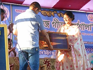
Anima Choudhury is a singer from the Indian north eastern state of Assam. Her musical career over more than four decades has focussed on folk and modern Assamese songs. She has been awarded local and state level musical and cultural recognitions and titles including. "Luit Kuwari", and "Jan Dimali". Some of her most popular songs are 'Dikhou noir parore', 'Log diyar kotha asil' and 'E pran gopal'.
Barkhetry Assembly constituency is one of the 126 assembly constituencies of Assam Legislative Assembly. Barkhetry forms part of the Gauhati Lok Sabha constituency.
Bahjani is an urban locality and mouza, in Nalbari district, Assam, India. Bahjani includes the Pub Bahjani, Uttar Bahjani, and Dakshin Bahjani areas, with a total of 25 villages. As per the 2001 census the Bahjani locality had a population of 44,472 people. As per the 2011 census the Bahjani locality has a population of 47,696 people.
Sondha, also spelled as Sandha, is a village in Nalbari district, Assam, India. As per the 2011 Census of India, Sondha has a population of 3,428 people with literacy rate of 76.95%.
Japarkuchi is an urban locality in Nalbari district, Assam, India. As per the 2011 Census of India, Japarkuchi has a population of 4,626 people including 2331 males and 2295 females, with a literacy rate of 87.44%.
Billeswar is a census village in the Pachim Nalbari subdivision, Nalbari district, Assam, India. As per 2011 census of India, Billeswar village has a population of 2,699 people, including 1,408 males and 1,291 females, and a literacy rate of 76.84%.
Buri Nagar, commonly known as Burinagar, is a census village under Natun Dehar Gram Panchayat in Nalbari district, Assam, India. As per 2011 Census of India, the village has a total population of 2,555 people, including 1,344 males and 1,211 females, and has a literacy rate of 75.34%.
Janigog is a census village in Nalbari district, Assam, India. As per the 2011 Census of India, Janigog has a total population of 3,795 people including 1,991 males and 1,804 females.
Kendukuchi is a census village in Nalbari district, Assam, India. As per the 2011 Census of India, Kendukuchi village has a total population of 2,390 people including 1,237 males and 1,153 females.
Arara is a census village in Nalbari district, Assam, India. According to the 2011 Census of India, Arara village has a total population of 2,823 people including 1,444 males and 1,379 females.
Namati is a village in Nalbari district, Assam, India. As per the 2011 Census of India, Namati village has a total population of 3,807 people including 1,943 males and 1,864 females.
Deharkalakuchi is a census village in Nalbari district, Assam, India. As per the 2011 Census of India, Deharkalakuchi has a total population of 2,802 people including 1,435 males and 1,367 females with a literacy rate of 64.85%.
Mugkuchi is a census village in Nalbari district, Assam, India. As per the 2011 Census of India, Mugkuchi village has a total population of 2,423 people including 1,240 males and 1,183 females with a literacy rate of 80.07%.
Pub-Kalakuchi, also spelled as Pub Kalakuchi, is a census village in Nalbari district, Assam, India. According to the 2011 Census of India, Pub-Kalakuchi village has a total population of 2,567 people including 1,323 males and 1,244 females with a literacy rate of 66.61%.

