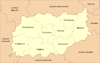
Sarnówko is a settlement in the administrative district of Gmina Kartuzy, within Kartuzy County, Pomeranian Voivodeship, in northern Poland. It lies approximately 9 kilometres (6 mi) south-west of Kartuzy and 36 km (22 mi) west of the regional capital Gdańsk.

Borcz-Leśniczówka is a settlement in the administrative district of Gmina Somonino, within Kartuzy County, Pomeranian Voivodeship, in northern Poland. It lies approximately 7 kilometres (4 mi) east of Somonino, 10 km (6 mi) south-east of Kartuzy, and 26 km (16 mi) south-west of the regional capital Gdańsk.

Chylowa Huta is a settlement in the administrative district of Gmina Somonino, within Kartuzy County, Pomeranian Voivodeship, in northern Poland. It lies approximately 9 kilometres (6 mi) south of Somonino, 16 km (10 mi) south of Kartuzy, and 36 km (22 mi) south-west of the regional capital Gdańsk.

Dębowo is a settlement in the administrative district of Gmina Somonino, within Kartuzy County, Pomeranian Voivodeship, in northern Poland. It lies approximately 5 kilometres (3 mi) south-west of Somonino, 11 km (7 mi) south of Kartuzy, and 34 km (21 mi) south-west of the regional capital Gdańsk.

Graniczny Dwór is a settlement in the administrative district of Gmina Somonino, within Kartuzy County, Pomeranian Voivodeship, in northern Poland. It lies approximately 3 kilometres (2 mi) south of Somonino, 9 km (6 mi) south of Kartuzy, and 31 km (19 mi) south-west of the regional capital Gdańsk.

Hopowo is a village in the administrative district of Gmina Somonino, within Kartuzy County, Pomeranian Voivodeship, in northern Poland. It lies approximately 4 kilometres (2 mi) south-east of Somonino, 9 km (6 mi) south of Kartuzy, and 29 km (18 mi) south-west of the regional capital Gdańsk.

Kamela is a village in the administrative district of Gmina Somonino, within Kartuzy County, Pomeranian Voivodeship, in northern Poland. It lies approximately 6 kilometres (4 mi) south-east of Somonino, 12 km (7 mi) south of Kartuzy, and 31 km (19 mi) south-west of the regional capital Gdańsk.

Koszowatka is a settlement in the administrative district of Gmina Somonino, within Kartuzy County, Pomeranian Voivodeship, in northern Poland. It lies approximately 5 kilometres (3 mi) south-west of Somonino, 10 km (6 mi) south-west of Kartuzy, and 35 km (22 mi) west of the regional capital Gdańsk.

Lisia Góra is a settlement in the administrative district of Gmina Somonino, within Kartuzy County, Pomeranian Voivodeship, in northern Poland. It lies approximately 6 kilometres (4 mi) south-east of Somonino, 12 km (7 mi) south of Kartuzy, and 29 km (18 mi) south-west of the regional capital Gdańsk.

Nowy Dwór is a settlement in the administrative district of Gmina Somonino, within Kartuzy County, Pomeranian Voivodeship, in northern Poland. It lies approximately 4 kilometres (2 mi) south-east of Somonino, 9 km (6 mi) south of Kartuzy, and 29 km (18 mi) south-west of the regional capital Gdańsk.

Ostowo is a settlement in the administrative district of Gmina Somonino, within Kartuzy County, Pomeranian Voivodeship, in northern Poland. It lies approximately 7 kilometres (4 mi) west of Somonino, 10 km (6 mi) south-west of Kartuzy, and 36 km (22 mi) west of the regional capital Gdańsk.

Piotrowo is a village in the administrative district of Gmina Somonino, within Kartuzy County, Pomeranian Voivodeship, in northern Poland. It lies approximately 10 kilometres (6 mi) south of Somonino, 16 km (10 mi) south of Kartuzy, and 38 km (24 mi) south-west of the regional capital Gdańsk.

Połęczyno is a village in the administrative district of Gmina Somonino, within Kartuzy County, Pomeranian Voivodeship, in northern Poland. It lies approximately 9 kilometres (6 mi) south of Somonino, 15 km (9 mi) south of Kartuzy, and 34 km (21 mi) south-west of the regional capital Gdańsk.

Pstra Suka is a settlement in the administrative district of Gmina Somonino, within Kartuzy County, Pomeranian Voivodeship, in northern Poland. It lies approximately 5 kilometres (3 mi) south-east of Somonino, 10 km (6 mi) south-east of Kartuzy, and 27 km (17 mi) south-west of the regional capital Gdańsk.

Rąty is a village in the administrative district of Gmina Somonino, within Kartuzy County, Pomeranian Voivodeship, in northern Poland. It lies approximately 4 kilometres (2 mi) south-west of Somonino, 10 km (6 mi) south of Kartuzy, and 34 km (21 mi) south-west of the regional capital Gdańsk.

Rokitki is a settlement in the administrative district of Gmina Somonino, within Kartuzy County, Pomeranian Voivodeship, in northern Poland. It lies approximately 4 kilometres (2 mi) west of Somonino, 9 km (6 mi) south-west of Kartuzy, and 34 km (21 mi) west of the regional capital Gdańsk.

Sławki is a village in the administrative district of Gmina Somonino, within Kartuzy County, Pomeranian Voivodeship, in northern Poland. It lies approximately 3 kilometres (2 mi) south-west of Somonino, 9 km (6 mi) south of Kartuzy, and 33 km (21 mi) west of the regional capital Gdańsk.

Sławki Górne is a village in the administrative district of Gmina Somonino, within Kartuzy County, Pomeranian Voivodeship, in northern Poland. It lies approximately 3 kilometres (2 mi) south of Somonino, 9 km (6 mi) south of Kartuzy, and 32 km (20 mi) south-west of the regional capital Gdańsk.

Wyczechowo-Osady is a settlement in the administrative district of Gmina Somonino, within Kartuzy County, Pomeranian Voivodeship, in northern Poland. It lies approximately 5 kilometres (3 mi) south-east of Somonino, 9 km (6 mi) south-east of Kartuzy, and 28 km (17 mi) south-west of the regional capital Gdańsk.

Kolano is a village in the administrative district of Gmina Stężyca, within Kartuzy County, Pomeranian Voivodeship, in northern Poland. It lies approximately 12 kilometres (7 mi) east of Stężyca, 12 km (7 mi) south-west of Kartuzy, and 37 km (23 mi) south-west of the regional capital Gdańsk.


