
An Earth observation satellite or Earth remote sensing satellite is a satellite used or designed for Earth observation (EO) from orbit, including spy satellites and similar ones intended for non-military uses such as environmental monitoring, meteorology, cartography and others. The most common type are Earth imaging satellites, that take satellite images, analogous to aerial photographs; some EO satellites may perform remote sensing without forming pictures, such as in GNSS radio occultation.

Envisat is a large Earth-observing satellite which has been inactive since 2012. It is still in orbit and considered space debris. Operated by the European Space Agency (ESA), it was the world's largest civilian Earth observation satellite.
SPOT is a commercial high-resolution optical Earth imaging satellite system operating from space. It is run by Spot Image, based in Toulouse, France. It was initiated by the CNES in the 1970s and was developed in association with the SSTC and the Swedish National Space Board (SNSB). It has been designed to improve the knowledge and management of the Earth by exploring the Earth's resources, detecting and forecasting phenomena involving climatology and oceanography, and monitoring human activities and natural phenomena. The SPOT system includes a series of satellites and ground control resources for satellite control and programming, image production, and distribution. Earlier satellites were launched using the European Space Agency's Ariane 2, 3, and 4 rockets, while SPOT 6 and SPOT 7 were launched by the Indian PSLV.

Satellite images are images of Earth collected by imaging satellites operated by governments and businesses around the world. Satellite imaging companies sell images by licensing them to governments and businesses such as Apple Maps and Google Maps.
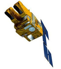
RADARSAT-2 is a Canadian Space Agency (CSA) Earth observation satellite. It launched on 14 December 2007 aboard a Starsem Soyuz-FG rocket from Baikonur Cosmodrome, Kazakhstan. The spacecraft is owned by MDA
QuickBird was a high-resolution commercial Earth observation satellite, owned by DigitalGlobe, launched in 2001 and reentered after orbit decay in 2015. QuickBird used Ball Aerospace's Global Imaging System 2000. The satellite collected panchromatic imagery at 61 centimeter resolution and multispectral imagery at 2.44- to 1.63-meter resolution, as orbit altitude is lowered during the end of mission life.

Cartosat-1 is a stereoscopic Earth observation satellite in a Sun-synchronous orbit, and the first one of the Cartosat series of satellites. The eleventh satellite of ISRO in Indian Remote Sensing Satellite (IRS) series. The satellite was launched by Indian Space Research Organisation and is operated by NTRO. Weighing around 1560 kg at launch, its applications will mainly be towards cartography in India.

RapidEye AG was a German geospatial information provider focused on assisting in management decision-making through services based on their own Earth-observation imagery. The company operated a five-satellite constellation producing 5-meter resolution imagery that was designed and implemented by MacDonald Dettwiler of Richmond, Canada.
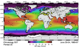
The Advanced Very-High-Resolution Radiometer (AVHRR) instrument is a space-borne sensor that measures the reflectance of the Earth in five spectral bands that are relatively wide by today's standards. AVHRR instruments are or have been carried by the National Oceanic and Atmospheric Administration (NOAA) family of polar orbiting platforms (POES) and European MetOp satellites. The instrument scans several channels; two are centered on the red (0.6 micrometres) and near-infrared (0.9 micrometres) regions, a third one is located around 3.5 micrometres, and another two the thermal radiation emitted by the planet, around 11 and 12 micrometres.

TerraSAR-X, is an imaging radar Earth observation satellite, a joint venture being carried out under a public-private-partnership between the German Aerospace Center (DLR) and EADS Astrium. The exclusive commercial exploitation rights are held by the geo-information service provider Astrium. TerraSAR-X was launched on 15 June 2007 and has been in operational service since January 2008. With its twin satellite TanDEM-X, launched 21 June 2010, TerraSAR-X acquires the data basis for the WorldDEM, the worldwide and homogeneous DEM available from 2014.

GeoEye Inc. was an American commercial satellite imagery company based in Herndon, Virginia. GeoEye was merged into the DigitalGlobe corporation on January 29, 2013.

A ground track or ground trace is the path on the surface of a planet directly below an aircraft's or satellite's trajectory. In the case of satellites, it is also known as a suborbital track or subsatellite track, and is the vertical projection of the satellite's orbit onto the surface of the Earth.

GCOM, is a JAXA project of long-term observation of Earth environmental changes. As a part of Japan's contributions to GEOSS, GCOM will be continued for 10 to 15 years with observation and utilization of global geophysical data such as precipitation, snow, water vapor, aerosol, for climate change prediction, water management, and food security. On May 18, 2012, the first satellite "GCOM-W" was launched. On December 23, 2017, the second satellite "GCOM-C1" was launched.
COSMO-SkyMed is an Earth-observation satellite space-based radar system funded by the Italian Ministry of Research and Ministry of Defence and conducted by the Italian Space Agency (ASI), intended for both military and civilian use. The prime contractor for the spacecraft was Thales Alenia Space. COSMO SkyMed is a constellation of four dual use Intelligence, surveillance, target acquisition, and reconnaissance (ISR) Earth observation satellites with a synthetic-aperture radar (SAR) as main payload, the result of the intuition of Giorgio Perrotta in the early nineties. The synthetic-aperture radar was developed starting in the late nineties with the SAR 2000 program funded by ASI.

Landsat 8 is an American Earth observation satellite launched on 11 February 2013. It is the eighth satellite in the Landsat program; the seventh to reach orbit successfully. Originally called the Landsat Data Continuity Mission (LDCM), it is a collaboration between NASA and the United States Geological Survey (USGS). NASA Goddard Space Flight Center in Greenbelt, Maryland, provided development, mission systems engineering, and acquisition of the launch vehicle while the USGS provided for development of the ground systems and will conduct on-going mission operations. It comprises the camera of the Operational Land Imager (OLI) and the Thermal Infrared Sensor (TIRS), which can be used to study Earth surface temperature and is used to study global warming.

Sentinel-1 is the first of the Copernicus Programme satellite constellation conducted by the European Space Agency. This mission was originally composed of a constellation of two satellites, Sentinel-1A and Sentinel-1B, which shared the same orbital plane. Two more satellites, Sentinel-1C and Sentinel-1D are in development. Sentinel-1B has been retired, leaving Sentinel-1A the only satellite of the constellation. The Sentinel-1 satellites carry a C-band synthetic-aperture radar instrument which provides a collection of data in all-weather, day or night. This instrument has a spatial resolution of down to 5 m and a swath of up to 410 km. The satellite orbits a Sun-synchronous, near-polar orbit. The orbit has a 12-day repeat cycle and completes 175 orbits per cycle.

Sentinel-3 is an Earth observation heavy satellite series developed by the European Space Agency as part of the Copernicus Programme. It currently consists of 2 satellites: Sentinel-3A and Sentinel-3B. After initial commissioning, each satellite was handed over to EUMETSAT for the routine operations phase of the mission. Two recurrent satellites— Sentinel-3C and Sentinel-3D— will follow in approximately 2024 and 2028 respectively to ensure continuity of the Sentinel-3 mission.

Oceansat-2 is the second Indian satellite built primarily for ocean applications. It was a part of the Indian Remote Sensing Programme satellite series. Oceansat-2 is an Indian satellite designed to provide service continuity for operational users of the Ocean Colour Monitor (OCM) instrument on Oceansat-1. It will also enhance the potential of applications in other areas. The OceanSat-2 mission was approved by the government of India on 16 July 2005.
IRS-1B, Indian Remote Sensing satellite-1B, the second of the series of indigenous state-of-art remote sensing satellites, was successfully launched into a polar Sun-synchronous orbit on 29 August 1991 from the Soviet Cosmodrome at Baikonur. IRS-1B carries two sensors, LISS-1 and LISS-2, with resolutions of 72 m (236 ft) and 36 m (118 ft) respectively with a swath width of about 140 km (87 mi) during each pass over the country. It was a part-operational, part-experimental mission to develop Indian expertise in satellite imagery. It was a successor to the remote sensing mission IRS-1A, both undertaken by the Indian Space Research Organisation (ISRO).
Resourcesat-2A is a follow on mission to Resourcesat-1 and Resourcesat-2 which were launched in October 2003 and in April 2011 respectively. The new satellite provides the same services as the other Resourcesat missions. It will give regular micro and macro information on land and water bodies below, farm lands and crop extent, forests, mineral deposits, coastal information, rural and urban spreads besides helping in disaster management.