Savaiʻi is the largest and highest island in Samoa and the Samoan Islands chain. The island is the sixth largest in Polynesia, behind the three main islands of New Zealand and the Hawaiian Islands of Hawaii and Maui.
Palauli is a district and village of Samoa, with a population of 9,300. It consists of two sections on the southern side of Savai'i. The capital is Vailoa which is also referred to as Vailoa i Palauli.

Neiafu is a village on the island of Savai'i in Samoa. It is in the Alataua Sisifo electoral district and located at the south west corner of the island. The population of Neiafu Uta is 598 and Neiafu Tai is 313.
Faleu is one of four small historic villages on Manono Island in Samoa. The village population is 354.

Not to be confused with Fagamalo, American Samoa
Satufia is a village on the island of Savai'i in Samoa. It is situated on the south coast of the island in the political district of Satupa'itea.
Vaega is a village on the island of Savai'i in Samoa. It is situated on the south coast of the island in the political district of Satupa'itea.
Moasula is a village on the island of Savai'i in Samoa. It is situated on the south coast of the island in the political district of Satupa'itea.

Sagone is a village on the island of Savai'i in Samoa. It is situated on the south coast of the island in the traditional district of Salega which falls within the larger political district (Itumalo) of Satupa'itea.
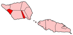
Salega is a traditional district on the island of Savai'i in Samoa. It is situated on the south side of the island. The population is 3,461.
Pitonu'u is a village on the island of Savai'i in Samoa. It is situated on the south side of the island in the political district of Satupa'itea.
Samata-i-Uta is a village on the island of Savai'i in Samoa. It is situated on the south side of the island in the traditional district (Faipule) and electoral constituency of Salega which falls within the larger political (Itumalo) district of Satupa'itea.
Samata-i-Tai is a village on the island of Savai'i in Samoa. It is situated on the south side of the island in the traditional district (Faipule) and the electoral constituency of Salega which falls within the larger political (Itumalo) district of Satupa'itea.
Fogasavai'i is a village on the island of Savai'i in Samoa. It is situated on the south east coast of the island in the traditional district of Salega which falls within the larger political district (Itumalo) of Satupa'itea.
Vaipua is a village on the island of Savai'i in Samoa. It is situated on the south east coast of the island in the traditional district of Salega which falls within the larger political district (Itumalo) of Satupa'itea.
Fai'a'ai is a village on the island of Savai'i in Samoa. It is situated on the south east coast of the island in the traditional district of Salega which falls within the larger political district (Itumalo) of Satupa'itea.
Fogatuli is a village on the island of Savai'i in Samoa. It is situated on the south east coast of the island in the traditional district of Salega which falls within the larger political district (Itumalo) of Satupa'itea.
Fagafau is a village on the island of Savai'i in Samoa. It is situated on the south east coast of the island in the traditional district of Salega which falls within the larger political district (Itumalo) of Satupa'itea.
Sa'asa'ai is a village at the east end of Savai'i island in Samoa. The village is part of the electoral constituency Fa'asaleleaga III which is within the larger political district (Itumalo) of Fa'asaleleaga.

Piula Theological College is a Methodist training institution in Samoa. It was established in 1868 in Lufilufi on the north coast of Upolu island after its initial beginnings in 1859 at Satupa'itea on the south coast of Savai'i island. The Methodist Mission in Samoa purchased the land at the Methodist leaning district and later named their training center Piula Theological College. The name Piula is a transliteration of the biblical name Beulah which means married.