Zschopau, is a town in the Erzgebirgskreis district of Saxony, Germany.

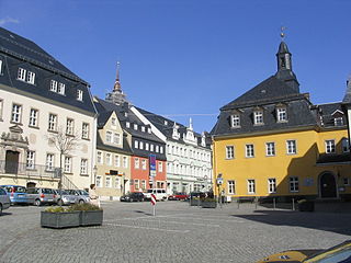
Marienberg is a town in Germany. It was the district capital of the Mittlerer Erzgebirgskreis in the southern part of Saxony, and since August 2008 it has been part of the new district of Erzgebirgskreis. As of 2020, the town had 16,716 inhabitants.
Olbernhau is a town in the district Erzgebirgskreis, in the Free State of Saxony, Germany. It is situated in the Ore Mountains, 35 km southeast of Chemnitz, and 23 km north of Chomutov, Czech Republic.
Oberwiesenthal is a town and a ski resort in the district of Erzgebirgskreis in Saxony in Germany. It is situated in the Ore Mountains, on the border with the Czech Republic, 19 km south of Annaberg-Buchholz, and 23 km northeast of Karlovy Vary. At 914 metres (2,999 ft), it is the highest town in Germany. The Olympic and World Championships goldmedalist in ski jumping Jens Weißflog competed for SC Tractor Oberwiesenthal and Oberwiesenthaler SV.

Wolkenstein is a town in the district Erzgebirgskreis, in the Free State of Saxony, Germany. It is situated in the Ore Mountains, on the Zschopau River, 22 km southeast of Chemnitz.

Königswalde is a municipality in the district of Erzgebirgskreis, in Saxony, Germany.

Gelenau is a municipality in the district of Erzgebirgskreis, in Saxony, Germany.

Großschönau is a municipality in the district Görlitz, in Saxony, Germany located in the Cross-border region with the Czech Republic. It used to be a famous Upper Lusatian center of Damask fabric production until the end of the 1980s. Since then it has turned into an area of tourism.

Deutschneudorf is a municipality in the district Erzgebirgskreis, in Saxony, Germany.

The village of Cämmerswalde in the municipality of Neuhausen/Erzgeb. lies in the south of the Saxon district of Mittelsachsen in eastern Germany. The state-recognised spa resort with its 800-year-old history, lies near Seiffen in the eastern part of the Western Ore Mountains not far from the Czech border. The village is a classic Waldhufendorf, with a length of over five kilometres. Cämmerswalde is divided into Oberdorf, Mitteldorf and Niederdorf. Since 1994 Cämmerswalde has belonged to the municipality of Neuhausen/Erzgeb., but used to be an independent parish with the hamlets of Deutschgeorgenthal, Haindorf and, from 1924, Neuwernsdorf and Rauschenbach.

Deutscheinsiedel is a village in the Saxon municipality of Deutschneudorf in the district of Erzgebirgskreis in East Germany.

Krumhermersdorf is a village in the large county borough of Zschopau in the district Erzgebirgskreis in eastern Germany. It was first mentioned in the records in 1369.
Frohnau is a village in the Saxon borough of Annaberg-Buchholz in the district of Erzgebirgskreis in southeast Germany. The discovery of silver on the Schreckenberg led in 1496 to the foundation of the neighbouring mining town of Annaberg. The village of Frohnau is best known for its museum of technology, the Frohnauer Hammer, and the visitor mine of Markus Röhling Stolln. The mining area around Frohnau has been selected as a candidate for a UNESCO world heritage site: the Ore Mountain Mining Region.
Wildenthal is a village in the town of Eibenstock in the district of Erzgebirgskreis in the Saxon Ore Mountains of Central Germany.
Lauta is a village in the Saxon town of Marienberg in the German district of Erzgebirgskreis.
Jugel is a division of the town of Johanngeorgenstadt in the German district of Erzgebirgskreis. This dispersed settlement is surrounded by woods, is divided into Ober- and Unterjugel and runs along the German-Czech border from the Lehmergrund to the crest of the Western Ore Mountains. In the vicinity lies the 980 metre-high Scheffelsberg. Jugel is a tourist destination for hikers and winter sportsmen.
The municipality of Hirtstein in Saxony, Germany was formed on 1 January 1994 from the hitherto separate municipalities of Rübenau, Reitzenhain, Kühnhaide and Satzung. Its administrative seat was Reitzenhain. The Hirtstein mountain near Satzung lent its name to the new municipality. Beginning on 1 January 2000, Hirtstein formed an administrative cooperation with the neighbouring town Marienberg. The merger with Marienberg was agreed upon on 24 June 2002 and became effective on 1 January 2003 when the constituents of Hirtstein became subdivisions of Marienberg.

Reitzenhain is a village in the Ore Mountains which is now a subdivision of Marienberg in the district Erzgebirgskreis.
Niederlauterstein is a village in Saxony which has been incorporated into the town of Marienberg in the district Erzgebirgskreis since 1996.
Hundshübel is a village in Erzgebirgskreis district of Saxony, forming a subdivision of the municipality of Stützengrün in the Ore Mountains. It is located north of Eibenstock Dam on federal highway B 169.


