Reitzenhain (Marienberg)

Last updated
Reitzenhain
Rathaus Reitzenhain.jpg
Town hall
Wappen Reitzenhain.png
Location of Reitzenhain
Reitzenhain (Marienberg)
Germany adm location map.svg
Red pog.svg
Reitzenhain
Saxony location map.svg
Red pog.svg
Reitzenhain
Coordinates: 50°33′40″N13°13′10″E / 50.56111°N 13.21944°E / 50.56111; 13.21944
Country Germany
State Saxony
District Erzgebirgskreis
Town Marienberg
Elevation
779 m (2,556 ft)
Population
 (2021) [1]
  Total279
Time zone UTC+01:00 (CET)
  Summer (DST) UTC+02:00 (CEST)
Postal codes
09496
Dialling codes 037364
Vehicle registration ERZ

Reitzenhain is a village in the Ore Mountains which is now a subdivision of Marienberg in the district Erzgebirgskreis.

Contents

Reitzenhain seen from Hirtstein Reitzenhain (Marienberg).JPG
Reitzenhain seen from Hirtstein
Reitzenhain, former railway station on the right Reitzenhain Bahnhof.jpg
Reitzenhain, former railway station on the right

Geography

Reitzenhain is located on the crest of the Ore Mountains, next to the border between Germany and the Czech Republic at an altitude of ca. 778 m (station building) on the stream Schwarze Pockau. The abandoned village Pohraniční (Böhmisch Reizenhain) is situated to its south-east, on the Czech side of the border and on the right bank of the stream.

Etymology

The name of the village is supposedly derived from a wayside inn (locally called a Han) on the nearby mountain pass, which happened to be the thirteenth inn ('Dreizehnter Han') on the road from Leipzig to Prague, counted from either end. [2] This is also reflected by the number "13" (German: 'Dreizehn') in the village's coat of arms.

History

Reitzenhain was first mentioned in a document of 1401 as Reiczenstein, being a village on the border to Bohemia. In 1551 it belonged to Großrückerswalde parish, in 1607 it was transferred to Kühnhaide parish. Reitzenhain children also attended school in Kühnhaide. Due to the strategically important location on the Reitzenhain pass, the village was frequently occupied by military forces, in particular in the Thirty Years' War and in the Seven Years' War. Until 1856 Reitzenhain belonged administratively to Amt Wolkenstein. [3]

The road between Marienberg and Reitzenhain was improved to rural highway standards in the first half of the 19th century. The railway from Chemnitz to Komotau via Marienberg was opened on 23 August 1875. The volunteer fire department was founded in 1879. A schoolhouse was opened in 1882. Peat digging started in 1891. Together with the neighbouring Reizenhain on the Czech side of the border, the Reitzenhain neighbourhood of Reißigmühle was connected to the electricity supply network in 1921. New municipal offices were inaugurated in 1924.

Kühnhaide was administratively joined with Reitzenhain on 1 October 1937, but became a separate municipality again on 1 April 1948. During World War II, a bomb dropped on the village in February 1945, destroyed one building and killed 14 people. In April 1945, a transport of prisoners from a subcamp of the Buchenwald concentration camp in Tröglitz, stopped in the village, and then the SS and local German civilians carried out a massacre of at least 380 prisoners, who tried to escape. [4] The surviving prisoners were sent on a death march to German-occupied Terezín. [4] After the war, the economical ties to Bohemia were interrupted, which caused a decline of the village.

Reitzenhain remained a separate municipality until 31 December 1993, it then joined with Kühnhaide, Rübenau, and Satzung to form the new municipality Hirtstein [5] of which it became the administrative seat. On 1 January 2003 Hirtstein joined Marienberg. [6]

Infrastructure

Bundesstraße 174 from Chemnitz ends on the border crossing to Hora Svatého Šebestiána and continues from there as National Road 7 to Chomutov.

Reitzenhain station was border station on the Saxon line Flöha-Reitzenhain which continued via Reizenhain (Pohraniční) to Chomutov. When cross-border traffic ceased after World War II, the station lost its importance. Passenger trains to Reitzenhain were cancelled on 1 October 1978, freight trains on 8 January 1994, the line between Marienberg and Reitzenhain was closed on 15 December 1998 and has been lifted in 2013 in favour of a bicycle and hiking path. [7] [8]

Reitzenhain has bus connections with Annaberg-Buchholz, Marienberg and Olbernhau on weekdays, and to Rübenau and Satzung on schooldays, provided by VMS.

People

Related Research Articles

<span class="mw-page-title-main">Dohna</span> Town in Saxony, Germany

Dohna is a town in the Sächsische Schweiz-Osterzgebirge district, Saxony, Germany. It is located south of Heidenau, in the Müglitz valley and lies at the northeastern foot of the Eastern Ore Mountains. It is accessed by the Pirna interchange of highway A17, and by the Dohna (Sachs) and Köttewitz stations of the Müglitz Valley Railway.

<span class="mw-page-title-main">Marienberg</span> Town in Saxony, Germany

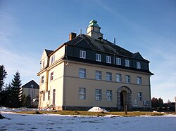
Marienberg is a town in Germany. It was the district capital of the Mittlerer Erzgebirgskreis in the southern part of Saxony, and since August 2008 it has been part of the new district of Erzgebirgskreis. As of 2020, the town had 16,716 inhabitants.

<span class="mw-page-title-main">Elsteraue</span> Municipality in Saxony-Anhalt, Germany

Elsteraue is a municipality in the Burgenlandkreis district in Saxony-Anhalt, in eastern Germany. It is situated near the White Elster river, about 30 km (20 mi) southwest of Leipzig.

<span class="mw-page-title-main">Wolkenstein</span> Town in Saxony, Germany

Wolkenstein is a town in the district Erzgebirgskreis, in Saxony, Germany. It is situated in the Ore Mountains, on the river Zschopau, 22 km southeast of Chemnitz.

<span class="mw-page-title-main">Jirkov</span> Town in Ústí nad Labem, Czech Republic

Jirkov is a town in Chomutov District in the Ústí nad Labem Region of the Czech Republic. It has about 19,000 inhabitants. Jirkov creates a conurbation with Chomutov.

<span class="mw-page-title-main">Weischlitz</span> Municipality in Saxony, Germany

Weischlitz is a municipality in the Vogtlandkreis district, in Saxony, Germany. It absorbed the former municipalities Kloschwitz and Kürbitz in 1999, Burgstein in 2011, and Reuth in 2017.

Mittelsachsen is a district (Kreis) in the Free State of Saxony, Germany.

<span class="mw-page-title-main">Pressnitz Valley Railway</span> Railway line in Germany

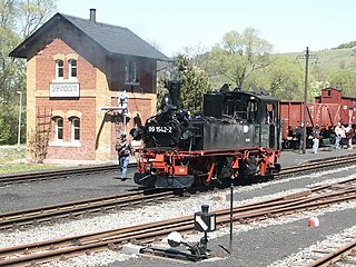
The Pressnitz Valley Railway was a narrow gauge railway line in Saxony, Germany. It used to climb from Wolkenstein on the standard gauge Annaberg-Buchholz–Flöha railway through the valley of river Preßnitz to Jöhstadt on the border with Bohemia. It was dismantled in the second half of the 1980s, however the Steinbach - Jöhstadt section was rebuilt as a museum railway after the fall of communism in East Germany.

<span class="mw-page-title-main">Kryštofovy Hamry</span> Municipality in Ústí nad Labem, Czech Republic

Kryštofovy Hamry is a municipality and village in Chomutov District in the Ústí nad Labem Region of the Czech Republic. It has about 200 inhabitants.

<span class="mw-page-title-main">Hirtstein</span>

Hirtstein is a mountain of Saxony, in southeastern Germany. It is situated near the village Satzung, in the Ore Mountains, about 1.5 km from the border to the Czech Republic. Its elevation is 890 m.

<span class="mw-page-title-main">Black Pockau</span> River in Germany

The Black Pockau is a river of Saxony, Germany, in the Ore Mountains. It is a left tributary of the Flöha. This virtually unspoilt wild stream with a length of 33 km (21 mi) is known for the picturesque gorge in its middle reaches.

<span class="mw-page-title-main">Reitzenhain–Flöha railway</span>

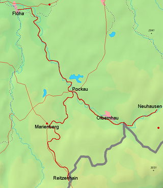
The Reitzenhain–Flöha railway, one of two lines also called the Flöha Valley Railway, is a branch line in Saxony in East Germany. It links the city of Chemnitz with Flöha, Lengefeld, Pockau, Olbernhau and Marienberg, formerly also Neuhausen/Erzgeb. and Reitzenhain and runs through the valleys of the Flöha and the Black Pockau. The line belongs today to DB Regio-Netz Erzgebirgsbahn.

<span class="mw-page-title-main">Annaberg-Buchholz–Flöha railway</span>

The Annaberg-Buchholz–Flöha railway, also called the Zschopau Valley Railway (Zschopautalbahn) is a branch line in the German state of Saxony. It links Annaberg-Buchholz lower station and the Vejprty–Annaberg-Buchholz railway line to Flöha, running through the Zschopau Valley via Wolkenstein and Zschopau. It has been operated since 2001 by the DB Regio subsidiary Erzgebirgsbahn.

<span class="mw-page-title-main">Chomutov–Vejprty/Reitzenhain railway</span>

The Chomutov–Reitzenhain railway and its branch to Vejprty is a branch line in the Czech Republic, that was originally built and operated by the Buschtěhrad Railway Company (BEB). It begins in Chomutov (Komotau), crosses the Ore Mountains, and ends today in the border station of Vejprty (Weipert), where there is a connexion to the German railway network over the Vejprty–Annaberg-Buchholz railway. The branch from Křimov to Reitzenhain has been closed since 1972.

<span class="mw-page-title-main">Erzgebirgsbahn</span>

The Erzgebirgsbahn is a German railway company and a RegioNetz subsidiary of Deutsche Bahn. It operates in the Ore Mountains region of southern Saxony, near the towns of Chemnitz and Zwickau.

<span class="mw-page-title-main">Vejprty–Annaberg-Buchholz railway</span>

The Vejprty–Annaberg-Buchholz railway is a branch line in the Czech Republic and the German state of Saxony. The line extends the Chomutov–Vejprty/Reitzenhain railway at Vejprty (Weipert), crossing the Czech-German border and running via Cranzahl to Annaberg-Buchholz. It has been operated since 2001 by Erzgebirgsbahn, which is part of DB Regio.

<span class="mw-page-title-main">Satzung</span> Ortsteil of Marienberg in Saxony, Germany

Satzung is a village in the Saxon municipality of Marienberg, which is in the district of Erzgebirgskreis in the German Ore Mountains.

The municipality of Hirtstein in Saxony, Germany was formed on 1 January 1994 from the hitherto separate municipalities of Rübenau, Reitzenhain, Kühnhaide and Satzung. Its administrative seat was Reitzenhain. The Hirtstein mountain near Satzung lent its name to the new municipality. Beginning on 1 January 2000, Hirtstein formed an administrative cooperation with the neighbouring town Marienberg. The merger with Marienberg was agreed upon on 24 June 2002 and became effective on 1 January 2003 when the constituents of Hirtstein became subdivisions of Marienberg.

Gehringswalde, a so-called Waldhufendorf, is situated about 1.5 km east of Wolkenstein in the Ore Mountains. It extends for about 1.5 km along the valley of a stream which joins the Zschopau river ca. 1.5 km west of Warmbad. The nearby Hüttengrundmühle is also part of the village. The mountain Dreibrüderhöhe lies ca. 3 km east of Gehringswalde.

<span class="mw-page-title-main">Pockau-Lengefeld station</span>

Pockau–Lengefeld station is a local railway junction in Pockau-Lengefeld in the German state of Saxony. The Pockau-Lengefeld–Neuhausen railway branches off the Reitzenhain–Flöha railway here. The station and lines were opened in 1875.

References

  1. "Zahlen und Fakten". Bergstadt Marienberg. Retrieved 24 September 2021.
  2. Karl-Heinz Melzer: Wolkenstein–Jöhstadt–Preßnitztal. VEB Tourist Verlag, Berlin/ Leipzig, 1979, S. 61.
  3. Historisches Ortsverzeichnis Sachsen
  4. 1 2 "Tröglitz/Rehmsdorf". aussenlager-buchenwald.de (in German). Retrieved 11 December 2023.
  5. Gemeinden 1994 und ihre Veränderungen seit 01.01.1948 in den neuen Ländern, Verlag Metzler-Poeschel, Stuttgart, 1995, ISBN   3-8246-0321-7, Statistisches Bundesamt
  6. Gebietsänderungen vom 01.01. bis 31.12.2003, Statistisches Bundesamt
  7. Freie Presse Online: Bagger räumt alte Bahnstrecke zwischen Marienberg und Reitzenhain für Radfahrer und Wanderer frei – Rückbauarbeiten auf dem 14 Kilometer langen Gleisabschnitt , retrieved 6 July 2015
  8. Niederschrift über die 12. Sitzung der Verbandsversammlung des Planungsverbandes Region Chemnitz am 12. November 2013 - öffentliche Sitzung, S. 30